
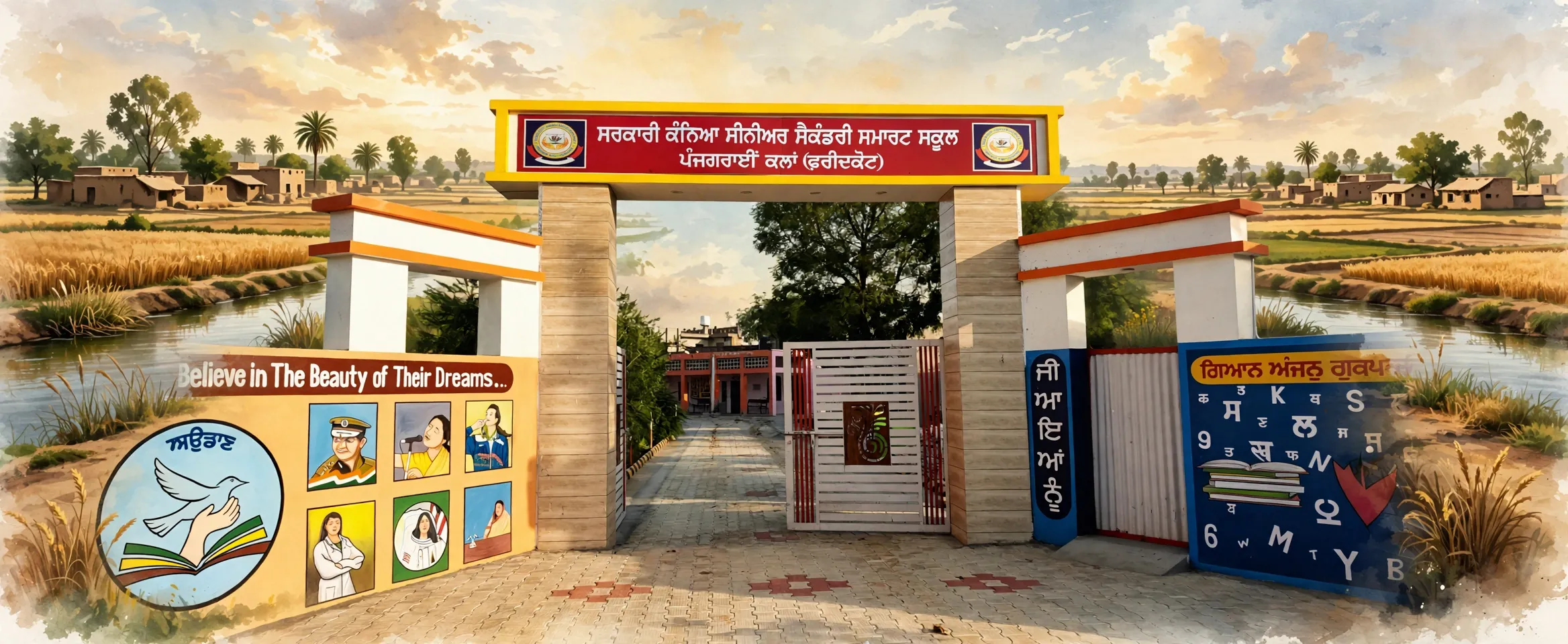
Panjgrain Kalan is a large village in Kot Kapura tehsil of Faridkot district, Punjab, with 10,663 people at the 2011 census. Governed by three gram panchayats and farmed almost entirely with canal water, it has one of the fullest school networks of any village in the district.
- Punjabi name
- ਪੰਜਗਰਾਈਂ ਕਲਾਂ
- District
- Faridkot
- Tehsil
- Kot Kapura
- Block
- Kot Kapura
- Gram Panchayat
- Panjgrain Kalan
- Population
- 10,663 (Census 2011)
All 13 facts
- Households
- 2,101 (Census 2011)
- Area
- 2,913 hectares
- Literacy
- 61.34% (Census 2011)
- Nearest town
- Kot Kapura (9 km)
- PIN code
- 151204
- Census village code
- 035588
- Known for
- Farming village of Kot Kapura tehsil
A canal village of three panchayats
Panjgrain Kalan is a large village in Kot Kapura tehsil of Faridkot district, Punjab, in the Malwa region, standing on the Kot Kapura to Moga road about nine kilometres from Kot Kapura town and some 21 kilometres from Faridkot. The 2011 census counted 10,663 people in 2,101 households across its 2,913 hectares, and the record carries village code 035588. Like Dhaula in Barnala district, it is one census village with more than one centre of local government: three gram panchayats run its parts, named Baba Jiwan Singh Nagar, Dashmesh Nagar Panjgrainkalan and Panj Grain Kalan. For politics the village votes in the Jaitu assembly constituency and the Faridkot Lok Sabha constituency.
Religious life and the Baba Jiwan Singh name
One of the three panchayats, Baba Jiwan Singh Nagar, carries the name of Baba Jiwan Singh, the revered Sikh of Guru Gobind Singh Ji's era, and the name keeps that memory in the village's everyday administration. The village's worship centres are the gurdwaras of its quarters, and its schools are where the village's named pattis, its historic quarters, are easiest to see: government primary schools serve Gill Patti, Kewal Patti and the main quarter of the village.
People and work
The 2011 census counted 5,580 men and 5,083 women in Panjgrain Kalan, a sex ratio of 911 women for every 1,000 men, living in 2,101 households at about 5.1 people to a household, a density of about 366 people per square kilometre. Children up to the age of six numbered 1,078, about 10 percent of the village. Scheduled Castes made up 3,889 people, about 36 percent of the population, and no Scheduled Tribe population was recorded. Literacy stood at 61.34 percent among residents aged seven and above, with men at 64.15 percent and women at 58.25 percent.
The census recorded 4,943 workers, about 46 percent of the village, the highest working share among the large villages of this part of Malwa. Of the 3,520 main workers, 1,036 cultivated their own land, 966 were agricultural labourers, 901 were other workers in trade, transport and services and 617 worked in household industry, an unusually large number of home based workers for a farming village. A further 1,423 people were marginal workers. Counting main and marginal workers together, agricultural labourers, at 1,320, outnumbered cultivators, at 1,097: this is a village where more families sell their labour in the fields than own the fields they work.
Land and farming
Farming covers almost the whole village. Of Panjgrain Kalan's 2,913 hectares, 2,654 hectares were net sown area in the 2011 record, and every sown hectare was irrigated: 2,651 hectares by canal and just 3 hectares by wells and tube wells. Few villages in the census record are as completely canal watered as this one. With 2,654 of its 2,913 hectares sown, more than nine tenths of the village is farmland. About 259 hectares were under non-agricultural uses such as the settlement and roads. Farm power supply was recorded at 8 hours a day.
Schools, health and everyday services
Panjgrain Kalan has the fullest school network of the large villages covered in this district: 3 government primary schools, 2 government middle schools, 2 government secondary schools and 2 government senior secondary schools, including the girls senior secondary school whose painted gate is pictured above and primary schools at Gill Patti, founded in 1994, Kewal Patti, founded in 1983, and the main quarter, founded in 1950. School listings for the village name both a boys and a girls senior secondary school. The village also has an anganwadi centre, though the nearest ASHA health worker was five to ten kilometres away in 2011.
On health, the 2011 Village Directory recorded a primary health centre inside the village, together with a veterinary hospital for its livestock. What the village did not have in 2011 was a community health centre, a primary health sub-centre, a dispensary or an allopathic hospital. Drinking water came from treated and untreated sources including hand pumps. The village had a sub post office, with the nearest full post office five to ten kilometres away, and mobile phone coverage, but in 2011 it had no internet common service centre and no PDS ration shop in the village itself; both were five to ten kilometres away. A commercial bank and a cooperative bank both had branches in the village, though there was no ATM. Domestic electricity supply was recorded at 18 hours a day.
Getting there
Panjgrain Kalan stands on the Kot Kapura to Moga road and is reached by pucca roads, and the 2011 directory recorded both public and private bus services in the village itself. Kot Kapura town is about nine kilometres away and Faridkot some 21 kilometres. In 2011 the nearest railway station was five to ten kilometres away. Neighbouring villages include Ghaniewala, Dhilwan Kalan, Jeonwala and Sibbian.
What is the population of Panjgrain Kalan?
The population of Panjgrain Kalan was 10,663 at the 2011 census, living in 2,101 households in Kot Kapura tehsil of Faridkot district, Punjab.
What does the village's farming run on?
Canal water. Of the 2,654 irrigated hectares recorded for Panjgrain Kalan in the Census 2011 Village Directory, 2,651 hectares were irrigated by canal and only 3 by wells and tube wells.
What health facilities does Panjgrain Kalan have?
The Census 2011 Village Directory recorded a primary health centre and a veterinary hospital inside Panjgrain Kalan. The village had no community health centre, sub-centre, dispensary or allopathic hospital in 2011.
ਤਿੰਨ ਪੰਚਾਇਤਾਂ ਵਾਲਾ ਨਹਿਰੀ ਪਿੰਡ
ਪੰਜਗਰਾਈਂ ਕਲਾਂ ਪੰਜਾਬ ਦੇ ਮਾਲਵਾ ਖੇਤਰ ਵਿੱਚ ਫਰੀਦਕੋਟ ਜ਼ਿਲ੍ਹੇ ਦੀ ਕੋਟ ਕਪੂਰਾ ਤਹਿਸੀਲ ਦਾ ਵੱਡਾ ਪਿੰਡ ਹੈ, ਜੋ ਕੋਟ ਕਪੂਰਾ ਤੋਂ ਮੋਗਾ ਵਾਲੀ ਸੜਕ ਉੱਤੇ ਕੋਟ ਕਪੂਰਾ ਸ਼ਹਿਰ ਤੋਂ ਲਗਭਗ ਨੌਂ ਕਿਲੋਮੀਟਰ ਅਤੇ ਫਰੀਦਕੋਟ ਤੋਂ ਲਗਭਗ 21 ਕਿਲੋਮੀਟਰ ਦੂਰ ਹੈ ਸਾਲ 2011 ਦੀ ਮਰਦਮਸ਼ੁਮਾਰੀ ਵਿੱਚ ਇਸ ਦੇ 2,913 ਹੈਕਟੇਅਰ ਵਿੱਚ 2,101 ਘਰਾਂ ਵਿੱਚ 10,663 ਲੋਕ ਸਨ ਅਤੇ ਰਿਕਾਰਡ ਵਿੱਚ ਇਸ ਦਾ ਪਿੰਡ ਕੋਡ 035588 ਹੈ ਬਰਨਾਲਾ ਜ਼ਿਲ੍ਹੇ ਦੇ ਧੌਲਾ ਵਾਂਗ, ਇਹ ਵੀ ਇੱਕੋ ਮਰਦਮਸ਼ੁਮਾਰੀ ਪਿੰਡ ਹੈ ਜਿਸ ਦੀ ਸਥਾਨਕ ਸਰਕਾਰ ਇੱਕ ਤੋਂ ਵੱਧ ਕੇਂਦਰਾਂ ਵਿੱਚ ਹੈ: ਤਿੰਨ ਗ੍ਰਾਮ ਪੰਚਾਇਤਾਂ ਇਸ ਦੇ ਹਿੱਸੇ ਚਲਾਉਂਦੀਆਂ ਹਨ, ਜਿਨ੍ਹਾਂ ਦੇ ਨਾਂ ਬਾਬਾ ਜੀਵਨ ਸਿੰਘ ਨਗਰ, ਦਸ਼ਮੇਸ਼ ਨਗਰ ਪੰਜਗਰਾਈਂਕਲਾਂ ਅਤੇ ਪੰਜ ਗਰਾਈਂ ਕਲਾਂ ਹਨ ਰਾਜਨੀਤਿਕ ਤੌਰ ਉੱਤੇ ਇਹ ਪਿੰਡ ਜੈਤੋ ਵਿਧਾਨ ਸਭਾ ਹਲਕੇ ਅਤੇ ਫਰੀਦਕੋਟ ਲੋਕ ਸਭਾ ਹਲਕੇ ਵਿੱਚ ਵੋਟ ਪਾਉਂਦਾ ਹੈ
ਧਾਰਮਿਕ ਜੀਵਨ ਅਤੇ ਬਾਬਾ ਜੀਵਨ ਸਿੰਘ ਦਾ ਨਾਂ
ਤਿੰਨਾਂ ਪੰਚਾਇਤਾਂ ਵਿੱਚੋਂ ਇੱਕ, ਬਾਬਾ ਜੀਵਨ ਸਿੰਘ ਨਗਰ, ਗੁਰੂ ਗੋਬਿੰਦ ਸਿੰਘ ਜੀ ਦੇ ਸਮੇਂ ਦੇ ਸ਼ਰਧਾਯੋਗ ਸਿੱਖ ਬਾਬਾ ਜੀਵਨ ਸਿੰਘ ਦਾ ਨਾਂ ਧਾਰਦੀ ਹੈ, ਅਤੇ ਇਹ ਨਾਂ ਉਸ ਯਾਦ ਨੂੰ ਪਿੰਡ ਦੇ ਰੋਜ਼ਾਨਾ ਪ੍ਰਬੰਧ ਵਿੱਚ ਜਿਉਂਦਾ ਰੱਖਦਾ ਹੈ ਪਿੰਡ ਦੇ ਪੂਜਾ ਸਥਾਨ ਇਸ ਦੇ ਹਿੱਸਿਆਂ ਦੇ ਗੁਰਦੁਆਰੇ ਹਨ, ਅਤੇ ਇਸ ਦੇ ਸਕੂਲ ਉਹ ਥਾਂ ਹਨ ਜਿੱਥੇ ਪਿੰਡ ਦੀਆਂ ਨਾਂ ਵਾਲੀਆਂ ਪੱਟੀਆਂ, ਇਸ ਦੇ ਇਤਿਹਾਸਕ ਹਿੱਸੇ, ਸਭ ਤੋਂ ਸੌਖੇ ਦਿਖਦੇ ਹਨ: ਸਰਕਾਰੀ ਪ੍ਰਾਇਮਰੀ ਸਕੂਲ ਗਿੱਲ ਪੱਟੀ, ਕੇਵਲ ਪੱਟੀ ਅਤੇ ਪਿੰਡ ਦੇ ਮੁੱਖ ਹਿੱਸੇ ਦੀ ਸੇਵਾ ਕਰਦੇ ਹਨ
ਲੋਕ ਅਤੇ ਕੰਮ
ਸਾਲ 2011 ਦੀ ਮਰਦਮਸ਼ੁਮਾਰੀ ਵਿੱਚ ਪੰਜਗਰਾਈਂ ਕਲਾਂ ਵਿੱਚ 5,580 ਮਰਦ ਅਤੇ 5,083 ਔਰਤਾਂ ਸਨ, ਹਰ 1,000 ਮਰਦਾਂ ਪਿੱਛੇ 911 ਔਰਤਾਂ, ਜੋ 2,101 ਘਰਾਂ ਵਿੱਚ ਰਹਿੰਦੇ ਸਨ ਛੇ ਸਾਲ ਤੱਕ ਦੇ ਬੱਚੇ 1,078 ਸਨ ਅਨੁਸੂਚਿਤ ਜਾਤੀਆਂ ਦੀ ਗਿਣਤੀ 3,889 ਸੀ, ਜੋ ਆਬਾਦੀ ਦਾ ਲਗਭਗ 36 ਫੀਸਦੀ ਹੈ ਸਾਖਰਤਾ 61.34 ਫੀਸਦੀ ਸੀ, ਮਰਦਾਂ ਵਿੱਚ 64.15 ਫੀਸਦੀ ਅਤੇ ਔਰਤਾਂ ਵਿੱਚ 58.25 ਫੀਸਦੀ
ਮਰਦਮਸ਼ੁਮਾਰੀ ਵਿੱਚ 4,943 ਕਾਮੇ ਦਰਜ ਹੋਏ, ਜੋ ਆਬਾਦੀ ਦਾ ਲਗਭਗ 46 ਫੀਸਦੀ ਹੈ, ਮਾਲਵੇ ਦੇ ਇਸ ਹਿੱਸੇ ਦੇ ਵੱਡੇ ਪਿੰਡਾਂ ਵਿੱਚ ਸਭ ਤੋਂ ਵੱਧ ਕੰਮ ਕਰਨ ਵਾਲਾ ਹਿੱਸਾ 3,520 ਮੁੱਖ ਕਾਮਿਆਂ ਵਿੱਚੋਂ 1,036 ਆਪਣੀ ਜ਼ਮੀਨ ਵਾਹੁੰਦੇ ਸਨ, 966 ਖੇਤ ਮਜ਼ਦੂਰ ਸਨ, 901 ਵਪਾਰ, ਆਵਾਜਾਈ ਅਤੇ ਸੇਵਾਵਾਂ ਵਿੱਚ ਹੋਰ ਕਾਮੇ ਸਨ ਅਤੇ 617 ਘਰੇਲੂ ਉਦਯੋਗ ਵਿੱਚ ਕੰਮ ਕਰਦੇ ਸਨ, ਜੋ ਖੇਤੀ ਵਾਲੇ ਪਿੰਡ ਲਈ ਘਰ ਬੈਠੇ ਕੰਮ ਕਰਨ ਵਾਲਿਆਂ ਦੀ ਅਸਾਧਾਰਨ ਵੱਡੀ ਗਿਣਤੀ ਹੈ ਇਸ ਤੋਂ ਇਲਾਵਾ 1,423 ਸੀਮਾਂਤ ਕਾਮੇ ਸਨ ਮੁੱਖ ਅਤੇ ਸੀਮਾਂਤ ਕਾਮਿਆਂ ਨੂੰ ਮਿਲਾ ਕੇ ਖੇਤ ਮਜ਼ਦੂਰ, 1,320, ਕਿਸਾਨਾਂ, 1,097, ਤੋਂ ਵੱਧ ਸਨ: ਇਹ ਅਜਿਹਾ ਪਿੰਡ ਹੈ ਜਿੱਥੇ ਖੇਤਾਂ ਦੇ ਮਾਲਕ ਬਣਨ ਨਾਲੋਂ ਵੱਧ ਪਰਿਵਾਰ ਖੇਤਾਂ ਵਿੱਚ ਆਪਣੀ ਮਿਹਨਤ ਵੇਚਦੇ ਹਨ
ਜ਼ਮੀਨ ਅਤੇ ਖੇਤੀ
ਖੇਤੀ ਲਗਭਗ ਸਾਰੇ ਪਿੰਡ ਨੂੰ ਘੇਰਦੀ ਹੈ ਪੰਜਗਰਾਈਂ ਕਲਾਂ ਦੇ 2,913 ਹੈਕਟੇਅਰ ਵਿੱਚੋਂ 2,654 ਹੈਕਟੇਅਰ ਸਾਲ 2011 ਵਿੱਚ ਸ਼ੁੱਧ ਬੀਜਿਆ ਖੇਤਰ ਸੀ ਅਤੇ ਹਰ ਬੀਜਿਆ ਹੈਕਟੇਅਰ ਸਿੰਜਿਆ ਹੋਇਆ ਸੀ: 2,651 ਹੈਕਟੇਅਰ ਨਹਿਰ ਨਾਲ ਅਤੇ ਸਿਰਫ 3 ਹੈਕਟੇਅਰ ਖੂਹਾਂ ਅਤੇ ਟਿਊਬਵੈੱਲਾਂ ਨਾਲ ਮਰਦਮਸ਼ੁਮਾਰੀ ਰਿਕਾਰਡ ਵਿੱਚ ਘੱਟ ਹੀ ਪਿੰਡ ਇੰਨੇ ਪੂਰੀ ਤਰ੍ਹਾਂ ਨਹਿਰੀ ਪਾਣੀ ਵਾਲੇ ਹਨ 2,913 ਹੈਕਟੇਅਰਾਂ ਵਿੱਚੋਂ 2,654 ਬੀਜੇ ਜਾਣ ਕਰਕੇ ਪਿੰਡ ਦਾ ਨੌਂ ਦਸਵੇਂ ਹਿੱਸੇ ਤੋਂ ਵੱਧ ਖੇਤੀ ਜ਼ਮੀਨ ਹੈ ਲਗਭਗ 259 ਹੈਕਟੇਅਰ ਗੈਰ-ਖੇਤੀ ਵਰਤੋਂ ਵਿੱਚ ਸੀ ਖੇਤੀ ਲਈ ਬਿਜਲੀ ਸਪਲਾਈ ਦਿਨ ਵਿੱਚ 8 ਘੰਟੇ ਦਰਜ ਹੋਈ
ਸਕੂਲ, ਸਿਹਤ ਅਤੇ ਰੋਜ਼ਾਨਾ ਸੇਵਾਵਾਂ
ਪੰਜਗਰਾਈਂ ਕਲਾਂ ਕੋਲ ਇਸ ਜ਼ਿਲ੍ਹੇ ਦੇ ਵੱਡੇ ਪਿੰਡਾਂ ਵਿੱਚ ਸਭ ਤੋਂ ਭਰਪੂਰ ਸਕੂਲ ਨੈੱਟਵਰਕ ਹੈ: 3 ਸਰਕਾਰੀ ਪ੍ਰਾਇਮਰੀ ਸਕੂਲ, 2 ਸਰਕਾਰੀ ਮਿਡਲ ਸਕੂਲ, 2 ਸਰਕਾਰੀ ਸੈਕੰਡਰੀ ਸਕੂਲ ਅਤੇ 2 ਸਰਕਾਰੀ ਸੀਨੀਅਰ ਸੈਕੰਡਰੀ ਸਕੂਲ, ਜਿਨ੍ਹਾਂ ਵਿੱਚ ਉਹ ਕੁੜੀਆਂ ਦਾ ਸੀਨੀਅਰ ਸੈਕੰਡਰੀ ਸਕੂਲ ਵੀ ਸ਼ਾਮਲ ਹੈ ਜਿਸ ਦਾ ਰੰਗਿਆ ਦਰਵਾਜ਼ਾ ਉੱਪਰ ਤਸਵੀਰ ਵਿੱਚ ਹੈ, ਅਤੇ ਗਿੱਲ ਪੱਟੀ, ਸਾਲ 1994 ਵਿੱਚ ਸਥਾਪਿਤ, ਕੇਵਲ ਪੱਟੀ, ਸਾਲ 1983 ਵਿੱਚ ਸਥਾਪਿਤ, ਅਤੇ ਮੁੱਖ ਹਿੱਸੇ, ਸਾਲ 1950 ਵਿੱਚ ਸਥਾਪਿਤ, ਦੇ ਪ੍ਰਾਇਮਰੀ ਸਕੂਲ ਪਿੰਡ ਦੀਆਂ ਸਕੂਲ ਸੂਚੀਆਂ ਵਿੱਚ ਮੁੰਡਿਆਂ ਅਤੇ ਕੁੜੀਆਂ ਦੋਵਾਂ ਲਈ ਸੀਨੀਅਰ ਸੈਕੰਡਰੀ ਸਕੂਲ ਦਰਜ ਹਨ ਪਿੰਡ ਵਿੱਚ ਆਂਗਣਵਾੜੀ ਕੇਂਦਰ ਵੀ ਹੈ, ਪਰ ਸਾਲ 2011 ਵਿੱਚ ਸਭ ਤੋਂ ਨੇੜਲੀ ਆਸ਼ਾ ਵਰਕਰ ਪੰਜ ਤੋਂ ਦਸ ਕਿਲੋਮੀਟਰ ਦੂਰ ਸੀ
ਸਿਹਤ ਬਾਰੇ ਸਾਲ 2011 ਦੇ Village Directory ਵਿੱਚ ਪਿੰਡ ਦੇ ਅੰਦਰ ਇੱਕ ਪ੍ਰਾਇਮਰੀ ਸਿਹਤ ਕੇਂਦਰ ਦਰਜ ਹੈ, ਨਾਲ ਹੀ ਪਸ਼ੂਆਂ ਲਈ ਪਸ਼ੂ ਹਸਪਤਾਲ ਵੀ ਜੋ ਪਿੰਡ ਵਿੱਚ ਸਾਲ 2011 ਵਿੱਚ ਨਹੀਂ ਸੀ, ਉਹ ਕਮਿਊਨਿਟੀ ਸਿਹਤ ਕੇਂਦਰ, ਸਿਹਤ ਸਬ-ਸੈਂਟਰ, ਡਿਸਪੈਂਸਰੀ ਜਾਂ ਐਲੋਪੈਥਿਕ ਹਸਪਤਾਲ ਸੀ ਪੀਣ ਵਾਲਾ ਪਾਣੀ ਸੋਧੇ ਅਤੇ ਅਣਸੋਧੇ ਸਰੋਤਾਂ ਤੋਂ ਆਉਂਦਾ ਸੀ, ਜਿਨ੍ਹਾਂ ਵਿੱਚ ਹੈਂਡ ਪੰਪ ਵੀ ਸਨ ਪਿੰਡ ਦਾ ਉਪ ਡਾਕਘਰ ਸੀ, ਸਭ ਤੋਂ ਨੇੜਲਾ ਪੂਰਾ ਡਾਕਘਰ ਪੰਜ ਤੋਂ ਦਸ ਕਿਲੋਮੀਟਰ ਦੂਰ ਸੀ, ਅਤੇ ਮੋਬਾਈਲ ਫੋਨ ਕਵਰੇਜ ਸੀ, ਪਰ ਸਾਲ 2011 ਵਿੱਚ ਪਿੰਡ ਵਿੱਚ ਨਾ ਇੰਟਰਨੈੱਟ ਸਾਂਝਾ ਸੇਵਾ ਕੇਂਦਰ ਸੀ ਅਤੇ ਨਾ ਪੀਡੀਐੱਸ ਰਾਸ਼ਨ ਦੁਕਾਨ; ਦੋਵੇਂ ਪੰਜ ਤੋਂ ਦਸ ਕਿਲੋਮੀਟਰ ਦੂਰ ਸਨ ਪਿੰਡ ਵਿੱਚ ਵਪਾਰਕ ਬੈਂਕ ਅਤੇ ਸਹਿਕਾਰੀ ਬੈਂਕ ਦੋਵਾਂ ਦੀਆਂ ਸ਼ਾਖਾਵਾਂ ਸਨ, ਪਰ ਏਟੀਐੱਮ ਨਹੀਂ ਸੀ ਘਰੇਲੂ ਬਿਜਲੀ ਸਪਲਾਈ ਦਿਨ ਵਿੱਚ 18 ਘੰਟੇ ਦਰਜ ਹੋਈ
ਉੱਥੇ ਪਹੁੰਚਣਾ
ਪੰਜਗਰਾਈਂ ਕਲਾਂ ਕੋਟ ਕਪੂਰਾ ਤੋਂ ਮੋਗਾ ਵਾਲੀ ਸੜਕ ਉੱਤੇ ਖੜ੍ਹਾ ਹੈ ਅਤੇ ਪੱਕੀਆਂ ਸੜਕਾਂ ਰਾਹੀਂ ਪਹੁੰਚਿਆ ਜਾਂਦਾ ਹੈ, ਅਤੇ ਸਾਲ 2011 ਦੀ ਡਾਇਰੈਕਟਰੀ ਵਿੱਚ ਪਿੰਡ ਵਿੱਚ ਸਰਕਾਰੀ ਅਤੇ ਨਿੱਜੀ ਦੋਵੇਂ ਬੱਸ ਸੇਵਾਵਾਂ ਦਰਜ ਸਨ ਕੋਟ ਕਪੂਰਾ ਸ਼ਹਿਰ ਲਗਭਗ ਨੌਂ ਕਿਲੋਮੀਟਰ ਦੂਰ ਹੈ ਅਤੇ ਫਰੀਦਕੋਟ ਲਗਭਗ 21 ਕਿਲੋਮੀਟਰ ਸਾਲ 2011 ਵਿੱਚ ਸਭ ਤੋਂ ਨੇੜਲਾ ਰੇਲਵੇ ਸਟੇਸ਼ਨ ਪੰਜ ਤੋਂ ਦਸ ਕਿਲੋਮੀਟਰ ਦੂਰ ਸੀ ਗੁਆਂਢੀ ਪਿੰਡਾਂ ਵਿੱਚ ਘਾਣੀਏਵਾਲਾ, ਢਿੱਲਵਾਂ ਕਲਾਂ, ਜਿਉਣਵਾਲਾ ਅਤੇ ਸਿੱਬੀਆਂ ਸ਼ਾਮਲ ਹਨ
ਪੰਜਗਰਾਈਂ ਕਲਾਂ ਦੀ ਆਬਾਦੀ ਕਿੰਨੀ ਹੈ?
ਸਾਲ 2011 ਦੀ ਮਰਦਮਸ਼ੁਮਾਰੀ ਵਿੱਚ ਪੰਜਗਰਾਈਂ ਕਲਾਂ ਦੀ ਆਬਾਦੀ 10,663 ਸੀ, ਜੋ ਪੰਜਾਬ ਦੇ ਫਰੀਦਕੋਟ ਜ਼ਿਲ੍ਹੇ ਦੀ ਕੋਟ ਕਪੂਰਾ ਤਹਿਸੀਲ ਵਿੱਚ 2,101 ਘਰਾਂ ਵਿੱਚ ਰਹਿੰਦੀ ਸੀ
ਪਿੰਡ ਦੀ ਖੇਤੀ ਕਿਸ ਉੱਤੇ ਚਲਦੀ ਹੈ?
ਨਹਿਰੀ ਪਾਣੀ ਉੱਤੇ ਸਾਲ 2011 ਦੇ Village Directory ਵਿੱਚ ਪੰਜਗਰਾਈਂ ਕਲਾਂ ਲਈ ਦਰਜ 2,654 ਸਿੰਜੇ ਹੈਕਟੇਅਰਾਂ ਵਿੱਚੋਂ 2,651 ਹੈਕਟੇਅਰ ਨਹਿਰ ਨਾਲ ਸਿੰਜੇ ਜਾਂਦੇ ਸਨ ਅਤੇ ਸਿਰਫ 3 ਖੂਹਾਂ ਅਤੇ ਟਿਊਬਵੈੱਲਾਂ ਨਾਲ
ਪੰਜਗਰਾਈਂ ਕਲਾਂ ਵਿੱਚ ਕਿਹੜੀਆਂ ਸਿਹਤ ਸਹੂਲਤਾਂ ਹਨ?
ਸਾਲ 2011 ਦੇ Village Directory ਅਨੁਸਾਰ ਪੰਜਗਰਾਈਂ ਕਲਾਂ ਦੇ ਅੰਦਰ ਇੱਕ ਪ੍ਰਾਇਮਰੀ ਸਿਹਤ ਕੇਂਦਰ ਅਤੇ ਇੱਕ ਪਸ਼ੂ ਹਸਪਤਾਲ ਦਰਜ ਸੀ ਸਾਲ 2011 ਵਿੱਚ ਪਿੰਡ ਵਿੱਚ ਕਮਿਊਨਿਟੀ ਸਿਹਤ ਕੇਂਦਰ, ਸਬ-ਸੈਂਟਰ, ਡਿਸਪੈਂਸਰੀ ਜਾਂ ਐਲੋਪੈਥਿਕ ਹਸਪਤਾਲ ਨਹੀਂ ਸੀ
Connected
More places to explore
Sources
- Panjgrain Kalan (126) Village Code 035588: District Census Handbook Village Directory data, VillageCodes Punjab
- Census of India 2011, Primary Census Abstract (village level), Faridkot district workbook, Office of the Registrar General & Census Commissioner
- Panjgrain Kalan, Wikipedia
- Panjgrain Kalan Village in Kot Kapura (Faridkot) Punjab, VillageInfo.in