
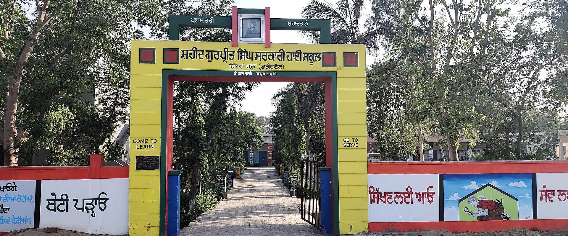
Dhilwan Kalan is a large village in Kot Kapura tehsil of Faridkot district, Punjab, a few kilometres from Kot Kapura. It counted 9,210 people in 2011 and is remembered in Sikh history for Guru Gobind Singh Ji's halt here in December 1705, marked by Gurdwara Godavari Sahib.
- Punjabi name
- ਧਿਲਵਾਂ ਕਲਾਂ
- District
- Faridkot
- Tehsil
- Kot Kapura
- Block
- Kot Kapura
- Gram Panchayat
- Dhilwan Kalan
- Population
- 9,210 (Census 2011)
All 13 facts
- Households
- 1,701 (Census 2011)
- Area
- 2,565 hectares
- Literacy
- 65.28% (Census 2011)
- Nearest town
- Kot Kapura (3 km)
- PIN code
- 151204
- Census village code
- 035589
- Known for
- Village of Kot Kapura tehsil
Where Dhilwan Kalan sits
Dhilwan Kalan is a large village in Kot Kapura tehsil of Faridkot district, Punjab, in the Malwa region, standing on the Bathinda to Faridkot road a few kilometres from Kot Kapura: the 2011 directory recorded the town as about 3 kilometres away. It has its own gram panchayat in the Kot Kapura development block, covers 2,565 hectares and carries census village code 035589, with PIN code 151204. Kalan, from the Persian for big, separates it from Dhilwan Khurd, the smaller village some of its families later founded near Sadik; it is a different place again from Dhilwan town in Kapurthala district, a confusion the history books themselves warn about. Villages recorded around it include Panjgrain Kalan, Sibbian and Ghaniewala, with Kot Kapura Rural wrapped around the town.
Guru Gobind Singh Ji at Dhilwan Kalan, 1705
In December 1705 Guru Gobind Singh Ji was crossing Malwa ahead of a pursuing imperial force, days after the evacuation of Anandpur and the fighting at Chamkaur. He had passed through Machhiwara dressed in blue as a Muslim holy man, the Uch da Pir disguise, and rested at Dina. At Kot Kapura he asked Chaudhry Kapura Brar for the use of his fort to make a stand against the pursuit, and Kapura refused; the town's side of that refusal is told on the Kot Kapura Rural page. The Guru moved on the few kilometres to this village, then called Dhilwan Sodhian after the Sodhi families settled here, who were his own kin.
He was received at the house of Kaul Sodhi, a descendant of Prithi Chand's branch of the Sodhi family. There, at Kaul's request, the Guru took off the blue robe he had worn since Machhiwara, tore it piece by piece and burned it, and put on white clothes that Kaul presented to him. The words tradition attaches to that moment say, in effect, that he had torn up the blue dress and with it the rule of the Turks and Pathans was finished. He stayed at Dhilwan Kalan for a couple of days. The Sodhi family of the village say the Guru left relics in their keeping when he moved on, among them a cap believed to have been Guru Nanak Dev Ji's, a cloak, socks, a turban and two daggers, which his descendants still preserve. Kapura, repenting of the refusal, is said to have come to the village to ask the Guru's forgiveness. Days later, on 29 December 1705, the pursuing army caught up at the pool of Khidrana and the battle of Muktsar was fought, where the forty Sikhs who had once deserted the Guru, led back by Mai Bhago of Jhabal, died fighting and were blessed as the Chali Mukte, the forty liberated ones.
Gurdwara Godavari Sahib
The halt is marked by Gurdwara Godavari Sahib, also called Godavarisar Patshahi Dasvin, which stands about 200 metres east of the village. Beside it lies the village pond where, by the account kept at the shrine, the Guru bathed during his stay; he named it Godavari Sar, and declared a dip in its water equal in merit to a dip in the Godavari river near Nanded, one of the most sacred rivers of central India. The promise is carried in the gurdwara's name to this day, and the shrine draws devotees from the villages around Kot Kapura.
People and work
The 2011 census counted 9,210 people in Dhilwan Kalan, up from 8,327 in 2001, growth of about 11 per cent: 4,835 men and 4,375 women living in 1,701 households, about 5.4 people to a household. Spread over 2,565 hectares, the density works out to about 359 people per square kilometre. The sex ratio was 905 women for every 1,000 men. Children up to the age of six numbered 1,011, about 11 per cent of the village. Scheduled Castes made up 4,153 people, about 45 per cent of the population, and no Scheduled Tribe population was recorded. The village's main communities are Jat Sikh families of the Dhillon, Dhaliwal, Sidhu and Brar, Bhullar and Gill clans, with Ramgarhia, Sodhi, Khatri and other households.
Literacy in 2011 stood at 65.28 per cent among residents aged seven and above, with men at 70.63 per cent and women at 59.41 per cent. The census recorded 3,247 workers, about 35 per cent of the village. Of the 2,890 main workers, the largest group, 1,110 people, were other workers in trade, transport and services, ahead of 876 cultivators and 847 agricultural labourers; a further 357 people were marginal workers. Counting everyone, the village held 895 cultivators against 987 agricultural labourers: next to a market town, its fields support more labouring families than landholding ones.
Land and farming
Of the village's 2,565 hectares, 2,308 hectares were net sown area in the 2011 record, and every sown hectare was irrigated from canals: the directory records 2,308 hectares of canal irrigation and no tubewell irrigation at all, a pattern that has become rare in Punjab. About 257 hectares were under non-agricultural uses. The crops recorded for the village are rice, wheat and cotton. The directory also records mud utensils made in the village and dariyan rugs as a local handicraft. Farm power supply was recorded at 15 hours a day, and an agricultural credit society was recorded in the village.
Schools and health
The Census 2011 Village Directory recorded one government school at every level in Dhilwan Kalan, primary, middle, secondary and senior secondary, so children can study in the village up to Class 12, and directory listings add private primary and middle schools. The village government high school carries a martyr's name: its gate, in this page's photograph, is lettered for Shaheed Gurpreet Singh. Government health care inside the village rests on a primary health sub-centre and a veterinary hospital; the census detail adds a maternity and child welfare centre, two registered medical practitioners, four faith healers and three medical shops, and Kot Kapura's hospitals are about 3 kilometres away. Drinking water in the directory table came from untreated tap water supplies. A sub post office serves the village, with the nearest full post office within 5 kilometres. A commercial bank stands in the village, while the cooperative bank, ATM and PDS ration shop were all within 5 kilometres in 2011. An anganwadi centre is in the village, the nearest ASHA worker within 5 kilometres, and domestic power supply was recorded at 18 hours a day.
Getting there
Both public and private bus services run in Dhilwan Kalan itself, on pucca roads; a state highway passes through the village, and the nearest railway station, at Kot Kapura, and a national highway are within about 5 to 10 kilometres. Kot Kapura, about 3 kilometres away, is the everyday hub for markets, colleges and administration, and Faridkot, the district headquarters, is about 21 kilometres away.
What is the population of Dhilwan Kalan?
The population of Dhilwan Kalan was 9,210 at the 2011 census, living in 1,701 households in Kot Kapura tehsil of Faridkot district. It had grown from 8,327 in 2001.
Why is Dhilwan Kalan important in Sikh history?
Dhilwan Kalan is where Guru Gobind Singh Ji halted in December 1705 after Kapura of Kot Kapura refused him the fort, and where, at Kaul Sodhi's house, he took off and burned the blue robe he had worn since Machhiwara, days before the battle of Muktsar. Gurdwara Godavari Sahib marks the halt.
How far is Dhilwan Kalan from Kot Kapura?
Dhilwan Kalan stands on the Bathinda to Faridkot road a few kilometres east of Kot Kapura; the 2011 directory recorded the town as its nearest, about 3 kilometres away.
ਧਿਲਵਾਂ ਕਲਾਂ ਕਿੱਥੇ ਹੈ
ਧਿਲਵਾਂ ਕਲਾਂ ਪੰਜਾਬ ਦੇ ਫਰੀਦਕੋਟ ਜ਼ਿਲ੍ਹੇ ਦੀ ਕੋਟ ਕਪੂਰਾ ਤਹਿਸੀਲ ਦਾ ਵੱਡਾ ਪਿੰਡ ਹੈ ਇਹ ਮਾਲਵਾ ਇਲਾਕੇ ਵਿੱਚ ਬਠਿੰਡਾ ਤੋਂ ਫਰੀਦਕੋਟ ਜਾਣ ਵਾਲੀ ਸੜਕ ਉੱਤੇ ਕੋਟ ਕਪੂਰਾ ਤੋਂ ਕੁਝ ਕਿਲੋਮੀਟਰ ਦੂਰ ਖੜਾ ਹੈ: 2011 ਦੀ ਡਾਇਰੈਕਟਰੀ ਨੇ ਸ਼ਹਿਰ ਨੂੰ ਲਗਭਗ 3 ਕਿਲੋਮੀਟਰ ਦੂਰ ਦਰਜ ਕੀਤਾ ਸੀ ਇਹ ਕੋਟ ਕਪੂਰਾ ਵਿਕਾਸ ਬਲਾਕ ਵਿੱਚ ਆਪਣੀ ਗ੍ਰਾਮ ਪੰਚਾਇਤ ਹੇਠ ਆਉਂਦਾ ਹੈ, ਇਸ ਦਾ ਰਕਬਾ 2,565 ਹੈਕਟੇਅਰ ਹੈ ਅਤੇ ਜਨਗਣਨਾ ਪਿੰਡ ਕੋਡ 035589 ਹੈ, ਪਿੰਨ ਕੋਡ 151204 ਹੈ ਕਲਾਂ, ਜੋ ਫ਼ਾਰਸੀ ਵਿੱਚ ਵੱਡੇ ਲਈ ਆਉਂਦਾ ਹੈ, ਇਸ ਨੂੰ ਧਿਲਵਾਂ ਖੁਰਦ ਤੋਂ ਵੱਖ ਕਰਦਾ ਹੈ, ਉਹ ਛੋਟਾ ਪਿੰਡ ਜੋ ਇਸ ਦੇ ਕੁਝ ਪਰਿਵਾਰਾਂ ਨੇ ਬਾਅਦ ਵਿੱਚ ਸਾਦਿਕ ਨੇੜੇ ਵਸਾਇਆ; ਇਹ ਕਪੂਰਥਲਾ ਜ਼ਿਲ੍ਹੇ ਦੇ ਧਿਲਵਾਂ ਸ਼ਹਿਰ ਤੋਂ ਵੀ ਵੱਖਰੀ ਥਾਂ ਹੈ, ਜਿਸ ਉਲਝਣ ਬਾਰੇ ਇਤਿਹਾਸ ਦੀਆਂ ਕਿਤਾਬਾਂ ਆਪ ਚੇਤਾਵਨੀ ਦਿੰਦੀਆਂ ਹਨ ਇਸ ਦੇ ਆਲੇ ਦੁਆਲੇ ਦਰਜ ਪਿੰਡਾਂ ਵਿੱਚ ਪੰਜਗਰਾਈਂ ਕਲਾਂ, ਸਿੱਬੀਆਂ ਅਤੇ ਘਨੀਏਵਾਲਾ ਸ਼ਾਮਲ ਹਨ, ਅਤੇ ਕੋਟ ਕਪੂਰਾ ਰੂਰਲ ਸ਼ਹਿਰ ਦੁਆਲੇ ਫੈਲਿਆ ਹੈ
ਧਿਲਵਾਂ ਕਲਾਂ ਵਿਖੇ ਗੁਰੂ ਗੋਬਿੰਦ ਸਿੰਘ ਜੀ, 1705
ਦਸੰਬਰ 1705 ਵਿੱਚ ਗੁਰੂ ਗੋਬਿੰਦ ਸਿੰਘ ਜੀ ਪਿੱਛਾ ਕਰਦੀ ਸ਼ਾਹੀ ਫੌਜ ਤੋਂ ਅੱਗੇ ਮਾਲਵੇ ਵਿੱਚੋਂ ਲੰਘ ਰਹੇ ਸਨ, ਆਨੰਦਪੁਰ ਦੀ ਨਿਕਾਸੀ ਅਤੇ ਚਮਕੌਰ ਦੀ ਲੜਾਈ ਤੋਂ ਕੁਝ ਦਿਨ ਬਾਅਦ ਉਹ ਮਾਛੀਵਾੜਾ ਵਿੱਚੋਂ ਮੁਸਲਮਾਨ ਫ਼ਕੀਰ ਦੇ ਨੀਲੇ ਪਹਿਰਾਵੇ ਵਿੱਚ, ਊਚ ਦਾ ਪੀਰ ਵਾਲੇ ਭੇਸ ਵਿੱਚ, ਲੰਘੇ ਸਨ ਅਤੇ ਦੀਨਾ ਵਿਖੇ ਠਹਿਰੇ ਸਨ ਕੋਟ ਕਪੂਰਾ ਵਿਖੇ ਉਨ੍ਹਾਂ ਨੇ ਚੌਧਰੀ ਕਪੂਰਾ ਬਰਾੜ ਤੋਂ ਪਿੱਛਾ ਕਰਦੀ ਫੌਜ ਨਾਲ ਟਾਕਰੇ ਲਈ ਉਸ ਦਾ ਕਿਲਾ ਮੰਗਿਆ, ਅਤੇ ਕਪੂਰੇ ਨੇ ਇਨਕਾਰ ਕਰ ਦਿੱਤਾ; ਉਸ ਇਨਕਾਰ ਦੀ ਸ਼ਹਿਰ ਵੱਲੋਂ ਕਹਾਣੀ ਕੋਟ ਕਪੂਰਾ ਰੂਰਲ ਵਾਲੇ ਪੰਨੇ ਉੱਤੇ ਦੱਸੀ ਗਈ ਹੈ ਗੁਰੂ ਜੀ ਕੁਝ ਕਿਲੋਮੀਟਰ ਅੱਗੇ ਇਸ ਪਿੰਡ ਆਏ, ਜੋ ਉਸ ਸਮੇਂ ਇੱਥੇ ਵਸੇ ਸੋਢੀ ਪਰਿਵਾਰਾਂ ਕਰਕੇ ਧਿਲਵਾਂ ਸੋਢੀਆਂ ਕਹਾਉਂਦਾ ਸੀ, ਜੋ ਉਨ੍ਹਾਂ ਦੇ ਆਪਣੇ ਰਿਸ਼ਤੇਦਾਰ ਸਨ
ਉਨ੍ਹਾਂ ਦਾ ਸਵਾਗਤ ਕਾਉਲ ਸੋਢੀ ਦੇ ਘਰ ਹੋਇਆ, ਜੋ ਸੋਢੀ ਪਰਿਵਾਰ ਦੀ ਪ੍ਰਿਥੀ ਚੰਦ ਵਾਲੀ ਸ਼ਾਖਾ ਦਾ ਵੰਸ਼ਜ ਸੀ ਉੱਥੇ, ਕਾਉਲ ਦੀ ਬੇਨਤੀ ਉੱਤੇ, ਗੁਰੂ ਜੀ ਨੇ ਮਾਛੀਵਾੜਾ ਤੋਂ ਪਾਇਆ ਨੀਲਾ ਪਹਿਰਾਵਾ ਲਾਹਿਆ, ਉਸ ਨੂੰ ਟੁਕੜੇ ਟੁਕੜੇ ਕਰਕੇ ਸਾੜ ਦਿੱਤਾ, ਅਤੇ ਕਾਉਲ ਵੱਲੋਂ ਪੇਸ਼ ਕੀਤੇ ਚਿੱਟੇ ਕੱਪੜੇ ਪਾ ਲਏ ਉਸ ਪਲ ਨਾਲ ਜੁੜੇ ਸ਼ਬਦਾਂ ਬਾਰੇ ਪ੍ਰੰਪਰਾ ਕਹਿੰਦੀ ਹੈ ਕਿ ਭਾਵ ਇਹ ਸੀ ਕਿ ਉਨ੍ਹਾਂ ਨੇ ਨੀਲਾ ਪਹਿਰਾਵਾ ਪਾੜ ਦਿੱਤਾ ਹੈ ਅਤੇ ਉਸ ਨਾਲ ਤੁਰਕਾਂ ਅਤੇ ਪਠਾਣਾਂ ਦਾ ਰਾਜ ਮੁੱਕ ਗਿਆ ਹੈ ਉਹ ਧਿਲਵਾਂ ਕਲਾਂ ਵਿੱਚ ਕੁਝ ਦਿਨ ਠਹਿਰੇ ਪਿੰਡ ਦਾ ਸੋਢੀ ਪਰਿਵਾਰ ਕਹਿੰਦਾ ਹੈ ਕਿ ਅੱਗੇ ਵਧਣ ਵੇਲੇ ਗੁਰੂ ਜੀ ਨੇ ਨਿਸ਼ਾਨੀਆਂ ਉਨ੍ਹਾਂ ਦੀ ਸੰਭਾਲ ਵਿੱਚ ਛੱਡੀਆਂ, ਜਿਨ੍ਹਾਂ ਵਿੱਚ ਗੁਰੂ ਨਾਨਕ ਦੇਵ ਜੀ ਦੀ ਮੰਨੀ ਜਾਂਦੀ ਇੱਕ ਟੋਪੀ, ਇੱਕ ਚੋਲਾ, ਜੁਰਾਬਾਂ, ਇੱਕ ਦਸਤਾਰ ਅਤੇ ਦੋ ਕਟਾਰਾਂ ਸ਼ਾਮਲ ਹਨ, ਜੋ ਉਸ ਦੇ ਵੰਸ਼ਜ ਅਜੇ ਵੀ ਸੰਭਾਲ ਕੇ ਰੱਖਦੇ ਹਨ ਕਪੂਰਾ, ਆਪਣੇ ਇਨਕਾਰ ਉੱਤੇ ਪਛਤਾਉਂਦਾ, ਕਥਿਤ ਤੌਰ ਉੱਤੇ ਪਿੰਡ ਆ ਕੇ ਗੁਰੂ ਜੀ ਤੋਂ ਮੁਆਫ਼ੀ ਮੰਗਣ ਆਇਆ ਕੁਝ ਦਿਨ ਬਾਅਦ, 29 ਦਸੰਬਰ 1705 ਨੂੰ, ਪਿੱਛਾ ਕਰਦੀ ਫੌਜ ਖਿਦਰਾਣੇ ਦੀ ਢਾਬ ਉੱਤੇ ਆ ਪਹੁੰਚੀ ਅਤੇ ਮੁਕਤਸਰ ਦੀ ਲੜਾਈ ਲੜੀ ਗਈ, ਜਿੱਥੇ ਗੁਰੂ ਜੀ ਨੂੰ ਕਦੇ ਛੱਡ ਗਏ ਚਾਲੀ ਸਿੱਖ, ਝਬਾਲ ਦੀ ਮਾਈ ਭਾਗੋ ਦੀ ਅਗਵਾਈ ਵਿੱਚ ਵਾਪਸ ਆਏ, ਲੜਦੇ ਮਾਰੇ ਗਏ ਅਤੇ ਚਾਲੀ ਮੁਕਤੇ ਕਹਾ ਕੇ ਬਖਸ਼ੇ ਗਏ
ਗੁਰਦੁਆਰਾ ਗੋਦਾਵਰੀ ਸਾਹਿਬ
ਇਸ ਠਹਿਰਾਅ ਦੀ ਨਿਸ਼ਾਨੀ ਗੁਰਦੁਆਰਾ ਗੋਦਾਵਰੀ ਸਾਹਿਬ ਹੈ, ਜਿਸ ਨੂੰ ਗੋਦਾਵਰੀਸਰ ਪਾਤਸ਼ਾਹੀ ਦਸਵੀਂ ਵੀ ਕਹਿੰਦੇ ਹਨ, ਜੋ ਪਿੰਡ ਤੋਂ ਲਗਭਗ 200 ਮੀਟਰ ਪੂਰਬ ਵੱਲ ਖੜਾ ਹੈ ਇਸ ਦੇ ਨਾਲ ਪਿੰਡ ਦਾ ਛੱਪੜ ਹੈ, ਜਿੱਥੇ ਧਾਰਮਿਕ ਸਥਾਨ ਉੱਤੇ ਰੱਖੀ ਕਥਾ ਅਨੁਸਾਰ ਗੁਰੂ ਜੀ ਨੇ ਆਪਣੇ ਠਹਿਰਾਅ ਦੌਰਾਨ ਇਸ਼ਨਾਨ ਕੀਤਾ ਸੀ; ਉਨ੍ਹਾਂ ਨੇ ਇਸ ਦਾ ਨਾਂ ਗੋਦਾਵਰੀ ਸਰ ਰੱਖਿਆ ਅਤੇ ਐਲਾਨ ਕੀਤਾ ਕਿ ਇਸ ਦੇ ਪਾਣੀ ਵਿੱਚ ਇਸ਼ਨਾਨ ਕੇਂਦਰੀ ਭਾਰਤ ਦੀਆਂ ਸਭ ਤੋਂ ਪਵਿੱਤਰ ਨਦੀਆਂ ਵਿੱਚੋਂ ਇੱਕ, ਨਾਂਦੇੜ ਨੇੜੇ ਵਗਦੀ ਗੋਦਾਵਰੀ ਨਦੀ ਵਿੱਚ ਇਸ਼ਨਾਨ ਦੇ ਬਰਾਬਰ ਪੁੰਨ ਵਾਲਾ ਹੈ ਇਹ ਵਚਨ ਅੱਜ ਤੱਕ ਗੁਰਦੁਆਰੇ ਦੇ ਨਾਂ ਵਿੱਚ ਜਿਉਂਦਾ ਹੈ, ਅਤੇ ਇਹ ਧਾਰਮਿਕ ਸਥਾਨ ਕੋਟ ਕਪੂਰਾ ਦੁਆਲੇ ਦੇ ਪਿੰਡਾਂ ਤੋਂ ਸ਼ਰਧਾਲੂ ਖਿੱਚਦਾ ਹੈ
ਲੋਕ ਅਤੇ ਕੰਮ
2011 ਦੀ ਜਨਗਣਨਾ ਨੇ ਧਿਲਵਾਂ ਕਲਾਂ ਵਿੱਚ 9,210 ਲੋਕ ਗਿਣੇ, ਜੋ 2001 ਵਿੱਚ 8,327 ਸਨ, ਲਗਭਗ 11 ਪ੍ਰਤੀਸ਼ਤ ਦਾ ਵਾਧਾ: 4,835 ਮਰਦ ਅਤੇ 4,375 ਔਰਤਾਂ 1,701 ਪਰਿਵਾਰਾਂ ਵਿੱਚ ਰਹਿੰਦੀਆਂ ਹਨ, ਹਰ ਪਰਿਵਾਰ ਵਿੱਚ ਲਗਭਗ 5.4 ਲੋਕ 2,565 ਹੈਕਟੇਅਰ ਵਿੱਚ ਫੈਲੇ ਹੋਣ ਕਰਕੇ ਘਣਤਾ ਲਗਭਗ 359 ਲੋਕ ਪ੍ਰਤੀ ਵਰਗ ਕਿਲੋਮੀਟਰ ਬਣਦੀ ਹੈ ਲਿੰਗ ਅਨੁਪਾਤ ਹਰ 1,000 ਮਰਦਾਂ ਪਿੱਛੇ 905 ਔਰਤਾਂ ਸੀ ਛੇ ਸਾਲ ਤੱਕ ਦੇ ਬੱਚੇ 1,011 ਸਨ, ਪਿੰਡ ਦਾ ਲਗਭਗ 11 ਪ੍ਰਤੀਸ਼ਤ ਅਨੁਸੂਚਿਤ ਜਾਤੀਆਂ ਦੇ ਲੋਕ 4,153 ਸਨ, ਆਬਾਦੀ ਦਾ ਲਗਭਗ 45 ਪ੍ਰਤੀਸ਼ਤ, ਅਤੇ ਕੋਈ ਅਨੁਸੂਚਿਤ ਕਬੀਲਾ ਆਬਾਦੀ ਦਰਜ ਨਹੀਂ ਹੋਈ ਪਿੰਡ ਦੇ ਮੁੱਖ ਭਾਈਚਾਰੇ ਢਿੱਲੋਂ, ਧਾਲੀਵਾਲ, ਸਿੱਧੂ ਅਤੇ ਬਰਾੜ, ਭੁੱਲਰ ਅਤੇ ਗਿੱਲ ਗੋਤਾਂ ਦੇ ਜੱਟ ਸਿੱਖ ਪਰਿਵਾਰ ਹਨ, ਨਾਲ ਰਾਮਗੜ੍ਹੀਆ, ਸੋਢੀ, ਖੱਤਰੀ ਅਤੇ ਹੋਰ ਪਰਿਵਾਰ
2011 ਵਿੱਚ ਸੱਤ ਸਾਲ ਅਤੇ ਉਸ ਤੋਂ ਵੱਧ ਉਮਰ ਦੇ ਵਸਨੀਕਾਂ ਵਿੱਚ ਸਾਖਰਤਾ 65.28 ਪ੍ਰਤੀਸ਼ਤ ਸੀ, ਜਿਸ ਵਿੱਚ ਮਰਦ 70.63 ਪ੍ਰਤੀਸ਼ਤ ਅਤੇ ਔਰਤਾਂ 59.41 ਪ੍ਰਤੀਸ਼ਤ ਸਨ ਜਨਗਣਨਾ ਨੇ 3,247 ਕਾਮੇ ਦਰਜ ਕੀਤੇ, ਪਿੰਡ ਦਾ ਲਗਭਗ 35 ਪ੍ਰਤੀਸ਼ਤ 2,890 ਮੁੱਖ ਕਾਮਿਆਂ ਵਿੱਚ ਸਭ ਤੋਂ ਵੱਡਾ ਸਮੂਹ, 1,110 ਲੋਕ, ਵਪਾਰ, ਢੋਆ-ਢੁਆਈ ਅਤੇ ਸੇਵਾਵਾਂ ਵਾਲੇ ਹੋਰ ਕਾਮੇ ਸਨ, ਜੋ 876 ਕਾਸ਼ਤਕਾਰਾਂ ਅਤੇ 847 ਖੇਤ ਮਜ਼ਦੂਰਾਂ ਤੋਂ ਅੱਗੇ ਸਨ ਹੋਰ 357 ਲੋਕ ਹਾਸ਼ੀਆ ਕਾਮੇ ਸਨ ਸਭ ਨੂੰ ਮਿਲਾ ਕੇ ਪਿੰਡ ਵਿੱਚ 895 ਕਾਸ਼ਤਕਾਰਾਂ ਦੇ ਮੁਕਾਬਲੇ 987 ਖੇਤ ਮਜ਼ਦੂਰ ਸਨ: ਮੰਡੀ ਵਾਲੇ ਸ਼ਹਿਰ ਦੇ ਨਾਲ ਲੱਗਦੇ ਇਸ ਪਿੰਡ ਦੇ ਖੇਤ ਜ਼ਮੀਨ ਮਾਲਕਾਂ ਨਾਲੋਂ ਮਜ਼ਦੂਰ ਪਰਿਵਾਰਾਂ ਨੂੰ ਵੱਧ ਸਹਾਰਾ ਦਿੰਦੇ ਹਨ
ਜ਼ਮੀਨ ਅਤੇ ਖੇਤੀ
ਪਿੰਡ ਦੇ 2,565 ਹੈਕਟੇਅਰ ਵਿੱਚੋਂ 2011 ਦੇ ਰਿਕਾਰਡ ਅਨੁਸਾਰ 2,308 ਹੈਕਟੇਅਰ ਸ਼ੁੱਧ ਬੀਜਿਆ ਰਕਬਾ ਸੀ, ਅਤੇ ਹਰ ਬੀਜਿਆ ਹੈਕਟੇਅਰ ਨਹਿਰਾਂ ਤੋਂ ਸਿੰਜਿਆ ਹੋਇਆ ਸੀ: ਡਾਇਰੈਕਟਰੀ 2,308 ਹੈਕਟੇਅਰ ਨਹਿਰੀ ਸਿੰਜਾਈ ਦਰਜ ਕਰਦੀ ਹੈ ਅਤੇ ਟਿਊਬਵੈੱਲ ਸਿੰਜਾਈ ਬਿਲਕੁਲ ਨਹੀਂ, ਜੋ ਅੱਜ ਦੇ ਪੰਜਾਬ ਵਿੱਚ ਦੁਰਲੱਭ ਹੋ ਗਿਆ ਢਾਂਚਾ ਹੈ ਲਗਭਗ 257 ਹੈਕਟੇਅਰ ਗੈਰ-ਖੇਤੀ ਵਰਤੋਂ ਹੇਠ ਸੀ ਪਿੰਡ ਦੀਆਂ ਦਰਜ ਫ਼ਸਲਾਂ ਚਾਵਲ, ਕਣਕ ਅਤੇ ਕਪਾਹ ਹਨ ਡਾਇਰੈਕਟਰੀ ਪਿੰਡ ਵਿੱਚ ਬਣਦੇ ਮਿੱਟੀ ਦੇ ਭਾਂਡੇ ਅਤੇ ਦਰੀਆਂ ਨੂੰ ਸਥਾਨਕ ਦਸਤਕਾਰੀ ਵਜੋਂ ਵੀ ਦਰਜ ਕਰਦੀ ਹੈ ਖੇਤੀ ਬਿਜਲੀ ਸਪਲਾਈ ਦਿਨ ਵਿੱਚ 15 ਘੰਟੇ ਦਰਜ ਹੋਈ, ਅਤੇ ਖੇਤੀ ਕਰਜ਼ਾ ਸੁਸਾਇਟੀ ਵੀ ਪਿੰਡ ਵਿੱਚ ਦਰਜ ਹੋਈ
ਸਕੂਲ ਅਤੇ ਸਿਹਤ
ਜਨਗਣਨਾ 2011 ਦੀ ਪਿੰਡ ਡਾਇਰੈਕਟਰੀ ਨੇ ਧਿਲਵਾਂ ਕਲਾਂ ਵਿੱਚ ਹਰ ਪੱਧਰ ਉੱਤੇ ਇੱਕ ਸਰਕਾਰੀ ਸਕੂਲ ਦਰਜ ਕੀਤਾ, ਪ੍ਰਾਇਮਰੀ, ਮਿਡਲ, ਸੈਕੰਡਰੀ ਅਤੇ ਸੀਨੀਅਰ ਸੈਕੰਡਰੀ, ਇਸ ਲਈ ਬੱਚੇ ਪਿੰਡ ਵਿੱਚ ਹੀ ਬਾਰ੍ਹਵੀਂ ਜਮਾਤ ਤੱਕ ਪੜ੍ਹ ਸਕਦੇ ਹਨ, ਅਤੇ ਡਾਇਰੈਕਟਰੀ ਸੂਚੀਆਂ ਪ੍ਰਾਈਵੇਟ ਪ੍ਰਾਇਮਰੀ ਅਤੇ ਮਿਡਲ ਸਕੂਲ ਵੀ ਜੋੜਦੀਆਂ ਹਨ ਪਿੰਡ ਦੇ ਸਰਕਾਰੀ ਹਾਈ ਸਕੂਲ ਦਾ ਨਾਂ ਇੱਕ ਸ਼ਹੀਦ ਦੇ ਨਾਂ ਉੱਤੇ ਹੈ: ਇਸ ਪੰਨੇ ਦੀ ਤਸਵੀਰ ਵਿੱਚ ਇਸ ਦਾ ਦਰਵਾਜ਼ਾ ਸ਼ਹੀਦ ਗੁਰਪ੍ਰੀਤ ਸਿੰਘ ਲਈ ਅੱਖਰਾਂ ਵਿੱਚ ਦਰਜ ਹੈ ਪਿੰਡ ਦੇ ਅੰਦਰ ਸਰਕਾਰੀ ਸਿਹਤ ਸੇਵਾ ਇੱਕ ਪ੍ਰਾਇਮਰੀ ਸਿਹਤ ਉਪ ਕੇਂਦਰ ਅਤੇ ਇੱਕ ਪਸ਼ੂ ਹਸਪਤਾਲ ਉੱਤੇ ਟਿਕੀ ਹੈ; ਜਨਗਣਨਾ ਵੇਰਵਾ ਇੱਕ ਜਣੇਪਾ ਅਤੇ ਬਾਲ ਭਲਾਈ ਕੇਂਦਰ, ਦੋ ਰਜਿਸਟਰਡ ਮੈਡੀਕਲ ਪ੍ਰੈਕਟੀਸ਼ਨਰ, ਚਾਰ ਨੀਮ ਹਕੀਮ ਅਤੇ ਤਿੰਨ ਦਵਾਈਆਂ ਦੀਆਂ ਦੁਕਾਨਾਂ ਵੀ ਜੋੜਦਾ ਹੈ, ਅਤੇ ਕੋਟ ਕਪੂਰਾ ਦੇ ਹਸਪਤਾਲ ਲਗਭਗ 3 ਕਿਲੋਮੀਟਰ ਦੂਰ ਹਨ ਡਾਇਰੈਕਟਰੀ ਸਾਰਣੀ ਵਿੱਚ ਪੀਣ ਵਾਲਾ ਪਾਣੀ ਬਿਨਾਂ ਸੋਧਿਆ ਨਲਕਾ ਪਾਣੀ ਸੀ ਉਪ ਡਾਕਘਰ ਪਿੰਡ ਦੀ ਸੇਵਾ ਕਰਦਾ ਹੈ, ਸਭ ਤੋਂ ਨੇੜਾ ਪੂਰਾ ਡਾਕਘਰ 5 ਕਿਲੋਮੀਟਰ ਦੇ ਅੰਦਰ ਹੈ ਵਪਾਰਕ ਬੈਂਕ ਪਿੰਡ ਵਿੱਚ ਹੈ, ਜਦੋਂ ਕਿ 2011 ਵਿੱਚ ਸਹਕਾਰੀ ਬੈਂਕ, ਏਟੀਐਮ ਅਤੇ ਪੀਡੀਐਸ ਰਾਸ਼ਨ ਦੁਕਾਨ ਸਭ 5 ਕਿਲੋਮੀਟਰ ਦੇ ਅੰਦਰ ਸਨ ਆਂਗਣਵਾੜੀ ਕੇਂਦਰ ਪਿੰਡ ਵਿੱਚ ਹੈ, ਸਭ ਤੋਂ ਨੇੜੀ ਆਸ਼ਾ ਵਰਕਰ 5 ਕਿਲੋਮੀਟਰ ਦੇ ਅੰਦਰ ਸੀ, ਅਤੇ ਘਰੇਲੂ ਬਿਜਲੀ ਸਪਲਾਈ ਦਿਨ ਵਿੱਚ 18 ਘੰਟੇ ਦਰਜ ਹੋਈ
ਉੱਥੇ ਕਿਵੇਂ ਪਹੁੰਚੀਏ
ਸਰਕਾਰੀ ਅਤੇ ਪ੍ਰਾਈਵੇਟ ਦੋਵੇਂ ਬੱਸ ਸੇਵਾਵਾਂ ਧਿਲਵਾਂ ਕਲਾਂ ਵਿੱਚ ਹੀ ਚੱਲਦੀਆਂ ਹਨ, ਪੱਕੀਆਂ ਸੜਕਾਂ ਉੱਤੇ; ਇੱਕ ਸੂਬਾਈ ਸ਼ਾਹਰਾਹ ਪਿੰਡ ਵਿੱਚੋਂ ਲੰਘਦਾ ਹੈ, ਅਤੇ ਸਭ ਤੋਂ ਨੇੜਾ ਰੇਲਵੇ ਸਟੇਸ਼ਨ, ਕੋਟ ਕਪੂਰਾ ਵਿਖੇ, ਅਤੇ ਇੱਕ ਰਾਸ਼ਟਰੀ ਸ਼ਾਹਰਾਹ ਲਗਭਗ 5 ਤੋਂ 10 ਕਿਲੋਮੀਟਰ ਦੇ ਅੰਦਰ ਹਨ ਲਗਭਗ 3 ਕਿਲੋਮੀਟਰ ਦੂਰ ਕੋਟ ਕਪੂਰਾ ਮੰਡੀਆਂ, ਕਾਲਜਾਂ ਅਤੇ ਪ੍ਰਸ਼ਾਸਨ ਲਈ ਰੋਜ਼ਾਨਾ ਦਾ ਕੇਂਦਰ ਹੈ, ਅਤੇ ਫਰੀਦਕੋਟ, ਜ਼ਿਲ੍ਹਾ ਸਦਰ ਮੁਕਾਮ, ਲਗਭਗ 21 ਕਿਲੋਮੀਟਰ ਦੂਰ ਹੈ
ਧਿਲਵਾਂ ਕਲਾਂ ਦੀ ਆਬਾਦੀ ਕਿੰਨੀ ਹੈ?
2011 ਦੀ ਜਨਗਣਨਾ ਵਿੱਚ ਧਿਲਵਾਂ ਕਲਾਂ ਦੀ ਆਬਾਦੀ 9,210 ਸੀ, ਜੋ ਫਰੀਦਕੋਟ ਜ਼ਿਲ੍ਹੇ ਦੀ ਕੋਟ ਕਪੂਰਾ ਤਹਿਸੀਲ ਵਿੱਚ 1,701 ਪਰਿਵਾਰਾਂ ਵਿੱਚ ਰਹਿੰਦੀ ਸੀ ਇਹ 2001 ਵਿੱਚ 8,327 ਤੋਂ ਵਧੀ ਸੀ
ਧਿਲਵਾਂ ਕਲਾਂ ਸਿੱਖ ਇਤਿਹਾਸ ਵਿੱਚ ਮਹੱਤਵਪੂਰਨ ਕਿਉਂ ਹੈ?
ਧਿਲਵਾਂ ਕਲਾਂ ਉਹ ਥਾਂ ਹੈ ਜਿੱਥੇ ਦਸੰਬਰ 1705 ਵਿੱਚ ਗੁਰੂ ਗੋਬਿੰਦ ਸਿੰਘ ਜੀ ਠਹਿਰੇ, ਜਦੋਂ ਕੋਟ ਕਪੂਰਾ ਦੇ ਕਪੂਰੇ ਨੇ ਉਨ੍ਹਾਂ ਨੂੰ ਕਿਲਾ ਦੇਣ ਤੋਂ ਇਨਕਾਰ ਕਰ ਦਿੱਤਾ ਸੀ, ਅਤੇ ਜਿੱਥੇ ਕਾਉਲ ਸੋਢੀ ਦੇ ਘਰ ਉਨ੍ਹਾਂ ਨੇ ਮਾਛੀਵਾੜਾ ਤੋਂ ਪਾਇਆ ਨੀਲਾ ਪਹਿਰਾਵਾ ਲਾਹ ਕੇ ਸਾੜ ਦਿੱਤਾ, ਮੁਕਤਸਰ ਦੀ ਲੜਾਈ ਤੋਂ ਕੁਝ ਦਿਨ ਪਹਿਲਾਂ ਗੁਰਦੁਆਰਾ ਗੋਦਾਵਰੀ ਸਾਹਿਬ ਇਸ ਠਹਿਰਾਅ ਦੀ ਨਿਸ਼ਾਨੀ ਹੈ
ਧਿਲਵਾਂ ਕਲਾਂ ਕੋਟ ਕਪੂਰਾ ਤੋਂ ਕਿੰਨਾ ਦੂਰ ਹੈ?
ਧਿਲਵਾਂ ਕਲਾਂ ਬਠਿੰਡਾ ਤੋਂ ਫਰੀਦਕੋਟ ਜਾਣ ਵਾਲੀ ਸੜਕ ਉੱਤੇ ਕੋਟ ਕਪੂਰਾ ਤੋਂ ਕੁਝ ਕਿਲੋਮੀਟਰ ਪੂਰਬ ਵੱਲ ਖੜਾ ਹੈ; 2011 ਦੀ ਡਾਇਰੈਕਟਰੀ ਨੇ ਸ਼ਹਿਰ ਨੂੰ ਇਸ ਦਾ ਸਭ ਤੋਂ ਨੇੜਾ, ਲਗਭਗ 3 ਕਿਲੋਮੀਟਰ ਦੂਰ, ਦਰਜ ਕੀਤਾ ਸੀ
Connected
More places to explore
Sources
- Dhilwan Kalan (127) Village Code 035589: District Census Handbook Village Directory data, VillageCodes Punjab
- Census of India 2011, Primary Census Abstract (village level), Faridkot district workbook, Office of the Registrar General & Census Commissioner
- Dhilwan Kalan village population 2001 and 2011, CityPopulation (Office of the Registrar General and Census Commissioner data)
- Dhilwan Kalan village details, OneFiveNine (Census 2011 District Census Handbook data)
- Dhilwan Kalan, Wikipedia
- Battle of Muktsar, Wikipedia