
Doda is a large village in Gidderbaha tehsil of Sri Muktsar Sahib district, Punjab, that works like a small town, with its own community health centre, police station, sub-tehsil office and post office. It had 13,070 people in 2,468 households at the 2011 census, with schools to Class 12 and banks on 4,346 hectares of canal-irrigated farmland.
- Punjabi name
- ਦੋਡਾ
- District
- Sri Muktsar Sahib
- Tehsil
- Gidderbaha
- Block
- Kot Bhai
- Gram Panchayat
- Doda
- Population
- 13,070 (Census 2011)
All 13 facts
- Households
- 2,468 (Census 2011)
- Area
- 4,346 hectares
- Literacy
- 63.12% (Census 2011)
- Nearest town
- Sri Muktsar Sahib (13 km)
- PIN code
- 152031
- Census village code
- 035358
- Known for
- Farming village of Gidderbaha tehsil
Where is Doda?
Doda is a large village in Gidderbaha tehsil of Sri Muktsar Sahib district in Punjab, India, in the Malwa region of the state. It stands on the Muktsar road (state highway 41), about 13 kilometres from Sri Muktsar Sahib, its nearest town in the census record, and about 10 kilometres from Gidderbaha, the tehsil headquarters. The village falls in the Kot Bhai community development block and has its own gram panchayat. In the census record it carries village code 035358, and it covers 4,346 hectares. For elections it falls in the Gidderbaha assembly constituency and the Faridkot parliamentary constituency.
A village that runs like a small town
Most villages of 13,000 people still send their residents to town for anything official. Doda does an unusual amount for itself. Local listings record a police station in the village, a sub-tehsil office, its own post office (Doda, PIN 152031) that serves the surrounding villages, a block primary education office, commercial and cooperative bank branches with an ATM, and a spread of shops and workshops along the Muktsar road and the Bathinda road. It is the kind of village the surrounding hamlets come to for work to be done, one of the two service centres of its block alongside Kot Bhai, the block's namesake village.
Health care: a community health centre of its own
The 2011 Village Directory gives Doda a health record few Punjab villages can match: a community health centre, a primary health centre, two primary health sub-centres, an allopathic hospital and a dispensary, besides a veterinary hospital. The community health centre, CHC Doda, stands behind the government school, and the two sub-centres, Doda-I and Doda-II, carry care into the village's own quarters. For a village this is hospital-level infrastructure, and it makes Doda the health address for the villages around it.
Religious places
Daily worship in Doda is served by the village's own gurdwaras and temples, and local listings record a dera, Dera Baba Dhyan Das, in the village. No shrine in Doda carries a documented history of wider fame, and this page does not invent one. The historic gurdwaras of the district are up the road in Sri Muktsar Sahib, where Gurdwara Tuti Gandi Sahib and the other shrines of the 1705 battle of Muktsar draw pilgrims all year, above all at the Maghi mela in January.
Population and people
The 2011 census counted 13,070 people in Doda: 6,825 men and 6,245 women, living in 2,468 households, an average of about 5.3 people per household. Spread over 4,346 hectares, the density works out to about 301 people per square kilometre. The sex ratio was 915 women for every 1,000 men, above the district figure of the time. Children up to the age of six numbered 1,573, about 12 per cent of the village. Scheduled Castes made up 5,360 people, about 41 per cent of the population, and no Scheduled Tribe population was recorded. Literacy stood at 63.12 per cent, with men at 69.48 per cent and women at 56.24 per cent.
Land, water and work
Of Doda's 4,346 hectares, 3,564 hectares were net sown area in 2011, and every sown hectare was irrigated, all of it from canals: the village's irrigation is entirely surface water from the canal network, not groundwater. About 578 hectares were under non-agricultural uses, the built-up share of a village that behaves like a small town, and 204 hectares were barren. The census recorded 4,715 workers, about 36 per cent of the village. Of the 4,250 main workers, the largest group, 1,688, were cultivators on their own land, closely followed by 1,558 agricultural labourers, with 967 other workers in trade, transport and services; a further 465 people were marginal workers, employed for only part of the year. Farm power supply was recorded at 8 hours a day, and domestic supply at a generous 18 hours.
Schools and services
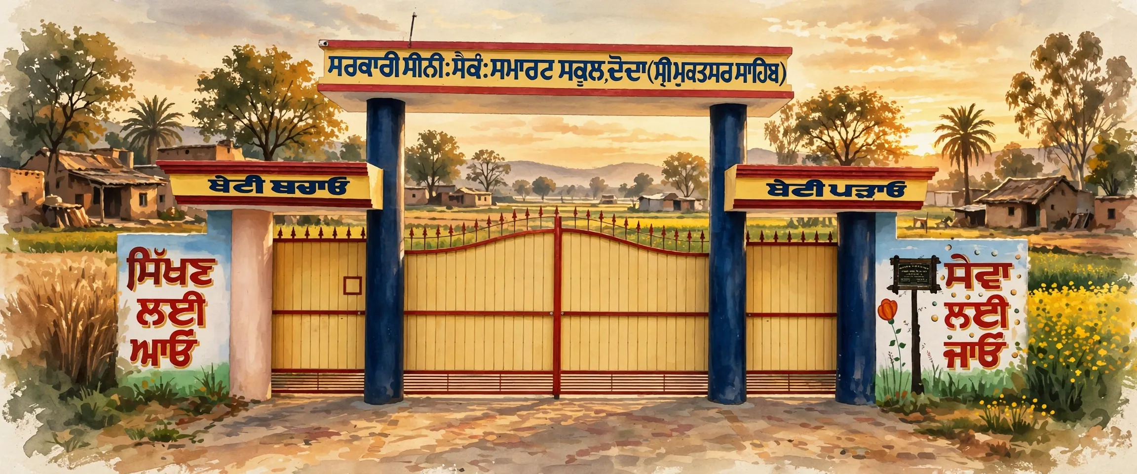
Education runs from the government primary schools up to the Government Senior Secondary School, Doda, whose painted main gate on the village road is a local landmark; private schools work alongside, among them the Akal Sahai Public School and the B.K.M Public School, the latter running since 1982. The village also had an anganwadi centre. Treated tap water was available. Banking is available in the village itself, with a commercial bank branch, a cooperative bank branch and an ATM. One gap in the record: the village had no PDS ration shop of its own in 2011, the nearest being more than ten kilometres away.
Getting there
Doda is reached by pucca roads on the Muktsar road corridor (state highway 41), and the 2011 directory recorded both public and private bus services in the village itself. Sri Muktsar Sahib, about 13 kilometres away, is the district headquarters, and Gidderbaha, the tehsil headquarters, about 10 kilometres away, has the nearest railway station, more than ten kilometres from the village. Neighbouring villages include Kauni, about 3 kilometres away, Giljewala, Duhewala, Sukhna Ablu and Chak Giljewala.
What is Doda known for?
Doda is known as a service village: it has its own community health centre and hospital-level care, a police station, a sub-tehsil office and a post office serving the surrounding villages, a rare set of institutions for a village of its size in Gidderbaha tehsil.
What is the population of Doda?
The population of Doda was 13,070 at the 2011 census, living in 2,468 households in Gidderbaha tehsil of Sri Muktsar Sahib district.
ਦੋਡਾ ਕਿੱਥੇ ਹੈ?
ਦੋਡਾ ਪੰਜਾਬ ਦੇ ਸ੍ਰੀ ਮੁਕਤਸਰ ਸਾਹਿਬ ਜ਼ਿਲ੍ਹੇ ਦੀ ਗਿੱਦੜਬਾਹਾ ਤਹਿਸੀਲ ਦਾ ਇੱਕ ਵੱਡਾ ਪਿੰਡ ਹੈ, ਜੋ ਮਾਲਵਾ ਖੇਤਰ ਵਿੱਚ ਪੈਂਦਾ ਹੈ ਇਹ ਮੁਕਤਸਰ ਸੜਕ (ਰਾਜ ਮਾਰਗ 41) ਉੱਤੇ ਖੜ੍ਹਾ ਹੈ, ਮਰਦਮਸ਼ੁਮਾਰੀ ਰਿਕਾਰਡ ਵਿੱਚ ਇਸ ਦੇ ਸਭ ਤੋਂ ਨੇੜਲੇ ਸ਼ਹਿਰ ਸ੍ਰੀ ਮੁਕਤਸਰ ਸਾਹਿਬ ਤੋਂ ਲਗਭਗ 13 ਕਿਲੋਮੀਟਰ ਅਤੇ ਤਹਿਸੀਲ ਹੈੱਡਕੁਆਰਟਰ ਗਿੱਦੜਬਾਹਾ ਤੋਂ ਲਗਭਗ 10 ਕਿਲੋਮੀਟਰ ਦੂਰ ਪਿੰਡ ਕੋਟ ਭਾਈ ਵਿਕਾਸ ਬਲਾਕ ਵਿੱਚ ਆਉਂਦਾ ਹੈ ਅਤੇ ਇਸ ਦੀ ਆਪਣੀ ਗ੍ਰਾਮ ਪੰਚਾਇਤ ਹੈ ਮਰਦਮਸ਼ੁਮਾਰੀ ਦੇ ਰਿਕਾਰਡ ਵਿੱਚ ਇਸ ਦਾ ਕੋਡ 035358 ਹੈ ਅਤੇ ਇਸ ਦਾ ਰਕਬਾ 4,346 ਹੈਕਟੇਅਰ ਹੈ ਚੋਣਾਂ ਪੱਖੋਂ ਇਹ ਗਿੱਦੜਬਾਹਾ ਵਿਧਾਨ ਸਭਾ ਹਲਕੇ ਅਤੇ ਫ਼ਰੀਦਕੋਟ ਲੋਕ ਸਭਾ ਹਲਕੇ ਵਿੱਚ ਆਉਂਦਾ ਹੈ
ਛੋਟੇ ਸ਼ਹਿਰ ਵਾਂਗ ਚੱਲਦਾ ਪਿੰਡ
13,000 ਅਬਾਦੀ ਵਾਲੇ ਜ਼ਿਆਦਾਤਰ ਪਿੰਡ ਅਜੇ ਵੀ ਸਰਕਾਰੀ ਕੰਮ ਲਈ ਆਪਣੇ ਲੋਕਾਂ ਨੂੰ ਸ਼ਹਿਰ ਭੇਜਦੇ ਹਨ ਦੋਡਾ ਆਪਣੇ ਲਈ ਅਸਾਧਾਰਨ ਤੌਰ ਉੱਤੇ ਬਹੁਤ ਕੁਝ ਖੁਦ ਕਰਦਾ ਹੈ ਸਥਾਨਕ ਸੂਚੀਆਂ ਅਨੁਸਾਰ ਪਿੰਡ ਵਿੱਚ ਪੁਲਿਸ ਥਾਣਾ, ਉਪ-ਤਹਿਸੀਲ ਦਫ਼ਤਰ, ਆਪਣਾ ਡਾਕਘਰ (ਦੋਡਾ, ਪਿੰਨ 152031) ਹੈ ਜੋ ਆਸ ਪਾਸ ਦੇ ਪਿੰਡਾਂ ਦੀ ਸੇਵਾ ਕਰਦਾ ਹੈ, ਬਲਾਕ ਪ੍ਰਾਇਮਰੀ ਸਿੱਖਿਆ ਦਫ਼ਤਰ, ਏ ਟੀ ਐਮ ਸਮੇਤ ਵਪਾਰਕ ਅਤੇ ਸਹਿਕਾਰੀ ਬੈਂਕਾਂ ਦੀਆਂ ਸ਼ਾਖਾਵਾਂ, ਅਤੇ ਮੁਕਤਸਰ ਸੜਕ ਤੇ ਬਠਿੰਡਾ ਸੜਕ ਉੱਤੇ ਦੁਕਾਨਾਂ ਅਤੇ ਵਰਕਸ਼ਾਪਾਂ ਦਾ ਫੈਲਾਅ ਹੈ ਇਹ ਉਹ ਪਿੰਡ ਹੈ ਜਿੱਥੇ ਆਸ ਪਾਸ ਦੇ ਛੋਟੇ ਪਿੰਡ ਕੰਮ ਕਰਵਾਉਣ ਆਉਂਦੇ ਹਨ, ਕੋਟ ਭਾਈ, ਬਲਾਕ ਦੇ ਨਾਮੀ ਪਿੰਡ, ਦੇ ਨਾਲ ਆਪਣੇ ਬਲਾਕ ਦੇ ਦੋ ਸੇਵਾ ਕੇਂਦਰਾਂ ਵਿੱਚੋਂ ਇੱਕ
ਸਿਹਤ ਸਹੂਲਤਾਂ: ਆਪਣਾ ਕਮਿਊਨਿਟੀ ਸਿਹਤ ਕੇਂਦਰ
2011 ਦੀ ਪਿੰਡ ਡਾਇਰੈਕਟਰੀ ਦੋਡਾ ਨੂੰ ਉਹ ਸਿਹਤ ਰਿਕਾਰਡ ਦਿੰਦੀ ਹੈ ਜੋ ਪੰਜਾਬ ਦੇ ਘੱਟ ਹੀ ਪਿੰਡਾਂ ਕੋਲ ਹੈ: ਇੱਕ ਕਮਿਊਨਿਟੀ ਸਿਹਤ ਕੇਂਦਰ, ਇੱਕ ਪ੍ਰਾਇਮਰੀ ਸਿਹਤ ਕੇਂਦਰ, ਦੋ ਪ੍ਰਾਇਮਰੀ ਸਿਹਤ ਉਪ-ਕੇਂਦਰ, ਇੱਕ ਐਲੋਪੈਥਿਕ ਹਸਪਤਾਲ ਅਤੇ ਇੱਕ ਡਿਸਪੈਂਸਰੀ, ਅਤੇ ਨਾਲ ਹੀ ਪਸ਼ੂਆਂ ਦਾ ਹਸਪਤਾਲ ਕਮਿਊਨਿਟੀ ਸਿਹਤ ਕੇਂਦਰ, ਸੀ ਐਚ ਸੀ ਦੋਡਾ, ਸਰਕਾਰੀ ਸਕੂਲ ਦੇ ਪਿੱਛੇ ਖੜ੍ਹਾ ਹੈ, ਅਤੇ ਦੋਵੇਂ ਉਪ-ਕੇਂਦਰ, ਦੋਡਾ-1 ਅਤੇ ਦੋਡਾ-2, ਪਿੰਡ ਦੇ ਆਪਣੇ ਮੁਹੱਲਿਆਂ ਤੱਕ ਸਿਹਤ ਸੇਵਾ ਪਹੁੰਚਾਉਂਦੇ ਹਨ ਕਿਸੇ ਪਿੰਡ ਲਈ ਇਹ ਹਸਪਤਾਲ ਪੱਧਰ ਦਾ ਢਾਂਚਾ ਹੈ, ਅਤੇ ਇਸ ਨਾਲ ਦੋਡਾ ਆਸ ਪਾਸ ਦੇ ਪਿੰਡਾਂ ਲਈ ਸਿਹਤ ਦਾ ਪਤਾ ਬਣਿਆ ਹੋਇਆ ਹੈ
ਧਾਰਮਿਕ ਸਥਾਨ
ਦੋਡਾ ਵਿੱਚ ਰੋਜ਼ਾਨਾ ਪੂਜਾ ਪਿੰਡ ਦੇ ਆਪਣੇ ਗੁਰਦੁਆਰਿਆਂ ਅਤੇ ਮੰਦਰਾਂ ਵਿੱਚ ਹੁੰਦੀ ਹੈ, ਅਤੇ ਸਥਾਨਕ ਸੂਚੀਆਂ ਵਿੱਚ ਪਿੰਡ ਵਿੱਚ ਇੱਕ ਡੇਰਾ, ਡੇਰਾ ਬਾਬਾ ਧਿਆਨ ਦਾਸ, ਦਰਜ ਹੈ ਦੋਡਾ ਦੇ ਕਿਸੇ ਵੀ ਧਾਰਮਿਕ ਸਥਾਨ ਦਾ ਦਸਤਾਵੇਜ਼ੀ ਇਤਿਹਾਸ ਵਿਸ਼ਾਲ ਪੱਧਰ ਉੱਤੇ ਜਾਣਿਆ ਨਹੀਂ ਜਾਂਦਾ, ਅਤੇ ਇਹ ਪੰਨਾ ਕੋਈ ਕਹਾਣੀ ਘੜਦਾ ਨਹੀਂ ਜ਼ਿਲ੍ਹੇ ਦੇ ਇਤਿਹਾਸਕ ਗੁਰਦੁਆਰੇ ਸੜਕ ਉੱਤੇ ਅੱਗੇ ਸ੍ਰੀ ਮੁਕਤਸਰ ਸਾਹਿਬ ਵਿੱਚ ਹਨ, ਜਿੱਥੇ ਗੁਰਦੁਆਰਾ ਟੁੱਟੀ ਗੰਢੀ ਸਾਹਿਬ ਅਤੇ 1705 ਦੀ ਮੁਕਤਸਰ ਦੀ ਲੜਾਈ ਦੇ ਹੋਰ ਧਾਰਮਿਕ ਸਥਾਨ ਸਾਰਾ ਸਾਲ ਸ਼ਰਧਾਲੂਆਂ ਨੂੰ ਖਿੱਚਦੇ ਹਨ, ਖਾਸ ਕਰਕੇ ਜਨਵਰੀ ਵਿੱਚ ਮਾਘੀ ਮੇਲੇ ਉੱਤੇ
ਅਬਾਦੀ ਅਤੇ ਲੋਕ
2011 ਦੀ ਮਰਦਮਸ਼ੁਮਾਰੀ ਅਨੁਸਾਰ ਦੋਡਾ ਦੀ ਅਬਾਦੀ 13,070 ਸੀ: 6,825 ਮਰਦ ਅਤੇ 6,245 ਔਰਤਾਂ, ਜੋ 2,468 ਪਰਿਵਾਰਾਂ ਵਿੱਚ ਰਹਿੰਦੇ ਸਨ, ਔਸਤਨ ਹਰ ਪਰਿਵਾਰ ਵਿੱਚ ਲਗਭਗ 5.3 ਜੀਅ 4,346 ਹੈਕਟੇਅਰ ਉੱਤੇ ਫੈਲੀ ਅਬਾਦੀ ਦੀ ਘਣਤਾ ਲਗਭਗ 301 ਜੀਅ ਪ੍ਰਤੀ ਵਰਗ ਕਿਲੋਮੀਟਰ ਬਣਦੀ ਹੈ ਲਿੰਗ ਅਨੁਪਾਤ ਹਰ 1,000 ਮਰਦਾਂ ਪਿਛੇ 915 ਔਰਤਾਂ ਸੀ, ਜੋ ਉਸ ਸਮੇਂ ਦੇ ਜ਼ਿਲ੍ਹੇ ਦੇ ਅੰਕੜੇ ਨਾਲੋਂ ਉੱਪਰ ਸੀ ਛੇ ਸਾਲ ਤੱਕ ਦੇ ਬੱਚੇ 1,573 ਸਨ, ਅਬਾਦੀ ਦਾ ਲਗਭਗ 12 ਫੀਸਦੀ ਅਨੁਸੂਚਿਤ ਜਾਤੀਆਂ ਦੀ ਅਬਾਦੀ 5,360 ਸੀ, ਲਗਭਗ 41 ਫੀਸਦੀ, ਅਤੇ ਕੋਈ ਅਨੁਸੂਚਿਤ ਜਨਜਾਤੀ ਅਬਾਦੀ ਦਰਜ ਨਹੀਂ ਸੀ ਸਾਖਰਤਾ ਦਰ 63.12 ਫੀਸਦੀ ਸੀ, ਮਰਦਾਂ ਵਿੱਚ 69.48 ਫੀਸਦੀ ਅਤੇ ਔਰਤਾਂ ਵਿੱਚ 56.24 ਫੀਸਦੀ
ਜ਼ਮੀਨ, ਪਾਣੀ ਅਤੇ ਕੰਮ-ਧੰਦੇ
ਦੋਡਾ ਦੇ 4,346 ਹੈਕਟੇਅਰ ਵਿੱਚੋਂ 2011 ਵਿੱਚ 3,564 ਹੈਕਟੇਅਰ ਵਾਹੀ ਹੇਠ ਸੀ, ਅਤੇ ਹਰ ਵਾਹੀ ਵਾਲਾ ਹੈਕਟੇਅਰ ਸਿੰਚਾਈ ਹੇਠ ਸੀ, ਸਾਰੀ ਸਿੰਚਾਈ ਨਹਿਰਾਂ ਤੋਂ: ਪਿੰਡ ਦੀ ਸਿੰਚਾਈ ਪੂਰੀ ਤਰ੍ਹਾਂ ਨਹਿਰੀ ਜਾਲ ਦੇ ਸਤਹੀ ਪਾਣੀ ਤੋਂ ਹੁੰਦੀ ਹੈ, ਧਰਤੀ ਹੇਠਲੇ ਪਾਣੀ ਤੋਂ ਨਹੀਂ ਲਗਭਗ 578 ਹੈਕਟੇਅਰ ਗੈਰ-ਖੇਤੀ ਵਰਤੋਂ ਹੇਠ ਸੀ, ਉਸ ਪਿੰਡ ਦਾ ਬਣਿਆ ਹੋਇਆ ਹਿੱਸਾ ਜੋ ਛੋਟੇ ਸ਼ਹਿਰ ਵਾਂਗ ਵਰਤਦਾ ਹੈ, ਅਤੇ 204 ਹੈਕਟੇਅਰ ਬੰਜਰ ਸੀ ਮਰਦਮਸ਼ੁਮਾਰੀ ਵਿੱਚ 4,715 ਕਾਮੇ ਦਰਜ ਹਨ, ਅਬਾਦੀ ਦਾ ਲਗਭਗ 36 ਫੀਸਦੀ 4,250 ਮੁੱਖ ਕਾਮਿਆਂ ਵਿੱਚੋਂ ਸਭ ਤੋਂ ਵੱਡਾ ਸਮੂਹ 1,688 ਆਪਣੀ ਜ਼ਮੀਨ ਵਾਹੁਣ ਵਾਲੇ ਕਿਸਾਨਾਂ ਦਾ ਸੀ, ਉਸ ਦੇ ਠੀਕ ਪਿੱਛੇ 1,558 ਖੇਤ ਮਜ਼ਦੂਰ ਸਨ, ਅਤੇ 967 ਹੋਰ ਕਾਮੇ ਵਪਾਰ, ਢੋਆ-ਢੁਆਈ ਅਤੇ ਸੇਵਾਵਾਂ ਵਿੱਚ ਸਨ; ਇਸ ਤੋਂ ਇਲਾਵਾ 465 ਜੀਅ ਸੀਮਾਂਤ ਕਾਮੇ ਸਨ, ਜੋ ਸਾਲ ਦਾ ਕੁਝ ਹਿੱਸਾ ਹੀ ਕੰਮ ਕਰਦੇ ਸਨ ਖੇਤੀ ਲਈ ਬਿਜਲੀ ਦਿਨ ਵਿੱਚ 8 ਘੰਟੇ ਅਤੇ ਘਰੇਲੂ ਸਪਲਾਈ ਖੁੱਲ੍ਹੇ 18 ਘੰਟੇ ਦਰਜ ਸੀ
ਸਕੂਲ ਅਤੇ ਸਹੂਲਤਾਂ
ਸਿੱਖਿਆ ਸਰਕਾਰੀ ਪ੍ਰਾਇਮਰੀ ਸਕੂਲਾਂ ਤੋਂ ਲੈ ਕੇ ਸਰਕਾਰੀ ਸੀਨੀਅਰ ਸੈਕੰਡਰੀ ਸਕੂਲ, ਦੋਡਾ, ਤੱਕ ਚੱਲਦੀ ਹੈ, ਜਿਸ ਦਾ ਪਿੰਡ ਦੀ ਸੜਕ ਉੱਤੇ ਰੰਗਿਆ ਮੁੱਖ ਦਰਵਾਜ਼ਾ ਸਥਾਨਕ ਪਛਾਣ ਹੈ; ਪ੍ਰਾਈਵੇਟ ਸਕੂਲ ਵੀ ਨਾਲ ਨਾਲ ਚੱਲਦੇ ਹਨ, ਜਿਨ੍ਹਾਂ ਵਿੱਚ ਅਕਾਲ ਸਹਾਏ ਪਬਲਿਕ ਸਕੂਲ ਅਤੇ ਬੀ ਕੇ ਐਮ ਪਬਲਿਕ ਸਕੂਲ ਸ਼ਾਮਲ ਹਨ, ਦੂਜਾ 1982 ਤੋਂ ਚੱਲ ਰਿਹਾ ਹੈ ਪਿੰਡ ਵਿੱਚ ਆਂਗਣਵਾੜੀ ਕੇਂਦਰ ਵੀ ਸੀ ਸਾਫ਼ ਕੀਤਾ ਨਲਕੇ ਦਾ ਪਾਣੀ ਮਿਲਦਾ ਸੀ ਬੈਂਕ ਸਹੂਲਤ ਪਿੰਡ ਵਿੱਚ ਹੀ ਹੈ, ਵਪਾਰਕ ਬੈਂਕ ਦੀ ਸ਼ਾਖਾ, ਸਹਿਕਾਰੀ ਬੈਂਕ ਦੀ ਸ਼ਾਖਾ ਅਤੇ ਏ ਟੀ ਐਮ ਨਾਲ ਰਿਕਾਰਡ ਵਿੱਚ ਇੱਕ ਘਾਟ: 2011 ਵਿੱਚ ਪਿੰਡ ਦੀ ਆਪਣੀ ਪੀ ਡੀ ਐਸ ਰਾਸ਼ਨ ਦੁਕਾਨ ਨਹੀਂ ਸੀ, ਸਭ ਤੋਂ ਨੇੜਲੀ ਦਸ ਕਿਲੋਮੀਟਰ ਤੋਂ ਵੱਧ ਦੂਰ ਸੀ
ਇੱਥੇ ਕਿਵੇਂ ਪਹੁੰਚੀਏ
ਦੋਡਾ ਮੁਕਤਸਰ ਸੜਕ ਗਲਿਆਰੇ (ਰਾਜ ਮਾਰਗ 41) ਉੱਤੇ ਪੱਕੀਆਂ ਸੜਕਾਂ ਨਾਲ ਜੁੜਿਆ ਹੈ ਅਤੇ 2011 ਦੇ ਰਿਕਾਰਡ ਅਨੁਸਾਰ ਪਿੰਡ ਵਿੱਚ ਸਰਕਾਰੀ ਅਤੇ ਪ੍ਰਾਈਵੇਟ ਦੋਵੇਂ ਬੱਸ ਸੇਵਾਵਾਂ ਸਨ ਜ਼ਿਲ੍ਹਾ ਹੈੱਡਕੁਆਰਟਰ ਸ੍ਰੀ ਮੁਕਤਸਰ ਸਾਹਿਬ ਲਗਭਗ 13 ਕਿਲੋਮੀਟਰ ਦੂਰ ਹੈ, ਅਤੇ ਤਹਿਸੀਲ ਹੈੱਡਕੁਆਰਟਰ ਗਿੱਦੜਬਾਹਾ ਲਗਭਗ 10 ਕਿਲੋਮੀਟਰ ਦੂਰ ਹੈ, ਜਿੱਥੇ ਸਭ ਤੋਂ ਨੇੜਲਾ ਰੇਲਵੇ ਸਟੇਸ਼ਨ ਹੈ, ਪਿੰਡ ਤੋਂ ਦਸ ਕਿਲੋਮੀਟਰ ਤੋਂ ਵੱਧ ਦੂਰ ਨੇੜਲੇ ਪਿੰਡਾਂ ਵਿੱਚ ਕਾਉਣੀ, ਲਗਭਗ 3 ਕਿਲੋਮੀਟਰ ਦੂਰ, ਗਿਲਜੇਵਾਲਾ, ਦੁਹੇਵਾਲਾ, ਸੁਖਣਾ ਅਬਲੂ ਅਤੇ ਚੱਕ ਗਿਲਜੇਵਾਲਾ ਸ਼ਾਮਲ ਹਨ
ਦੋਡਾ ਕਿਸ ਲਈ ਜਾਣਿਆ ਜਾਂਦਾ ਹੈ?
ਦੋਡਾ ਇੱਕ ਸੇਵਾ ਪਿੰਡ ਵਜੋਂ ਜਾਣਿਆ ਜਾਂਦਾ ਹੈ: ਇਸ ਕੋਲ ਆਪਣਾ ਕਮਿਊਨਿਟੀ ਸਿਹਤ ਕੇਂਦਰ ਅਤੇ ਹਸਪਤਾਲ ਪੱਧਰ ਦੀ ਸਿਹਤ ਸੇਵਾ, ਪੁਲਿਸ ਥਾਣਾ, ਉਪ-ਤਹਿਸੀਲ ਦਫ਼ਤਰ ਅਤੇ ਆਸ ਪਾਸ ਦੇ ਪਿੰਡਾਂ ਦੀ ਸੇਵਾ ਕਰਦਾ ਡਾਕਘਰ ਹੈ, ਸੰਸਥਾਵਾਂ ਦਾ ਉਹ ਸਮੂਹ ਜੋ ਗਿੱਦੜਬਾਹਾ ਤਹਿਸੀਲ ਵਿੱਚ ਇਸ ਆਕਾਰ ਦੇ ਪਿੰਡ ਲਈ ਕਾਫ਼ੀ ਘੱਟ ਮਿਲਦਾ ਹੈ
ਦੋਡਾ ਦੀ ਅਬਾਦੀ ਕਿੰਨੀ ਹੈ?
2011 ਦੀ ਮਰਦਮਸ਼ੁਮਾਰੀ ਅਨੁਸਾਰ ਦੋਡਾ ਦੀ ਅਬਾਦੀ 13,070 ਸੀ, ਜੋ ਸ੍ਰੀ ਮੁਕਤਸਰ ਸਾਹਿਬ ਜ਼ਿਲ੍ਹੇ ਦੀ ਗਿੱਦੜਬਾਹਾ ਤਹਿਸੀਲ ਵਿੱਚ 2,468 ਪਰਿਵਾਰਾਂ ਵਿੱਚ ਰਹਿੰਦੀ ਸੀ
Connected
Doda in the news
 Punjab Police Arrest LPU Student in Doda; Second Escapes Raid in Kishtwarਡੋਡਾ 'ਚੋਂ ਐੱਲਪੀਯੂ ਵਿਦਿਆਰਥੀ ਗ੍ਰਿਫ਼ਤਾਰ; ਕਿਸ਼ਤਵਾੜ 'ਚ ਛਾਪੇ ਤੋਂ ਪਹਿਲਾਂ ਦੂਜਾ ਫ਼ਰਾਰ
More places to explore
Sources
- Doda (75) Village Code 035358: District Census Handbook Village Directory data, VillageCodes Punjab
- Census of India 2011, Primary Census Abstract (village level), Muktsar district workbook, Office of the Registrar General & Census Commissioner
- Doda village, Gidderbaha tehsil, Muktsar district: OneFiveNine village directory
- Entrance of Govt. Senior Secondary School Doda (Sri Muktsar Sahib): photograph by Stalinjeet Brar, CC BY-SA 4.0, Wikimedia Commons
- Sri Muktsar Sahib: Wikipedia