
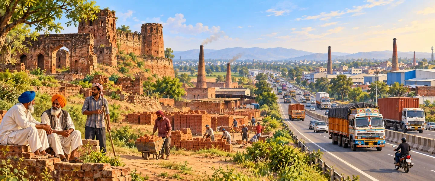
Dera Bassi is a town in SAS Nagar (Mohali) district on the Chandigarh to Delhi highway, close to the Haryana border. It was a tehsil town of the Kalsia princely state, whose rulers used its Mughal era fort as a guest house. Today it is an industrial satellite of Chandigarh. The 2011 census counted 26,295 people.
- ਪੰਜਾਬੀ ਨਾਂ
- ਡੇਰਾ ਬੱਸੀ
- ਕਿਸਮ
- Town (Municipal Council)
- ਜ਼ਿਲ੍ਹਾ
- ਐੱਸਏਐੱਸ ਨਗਰ (ਮੋਹਾਲੀ)
- Tehsil
- ਡੇਰਾ ਬੱਸੀ
- ਇਲਾਕਾ
- Puadh, Punjab (India)
- ਸਥਾਪਨਾ
- Tehsil town of Kalsia State, founded in the 1760s
All 11 facts
- ਆਬਾਦੀ
- 26,295 (2011 census)
- PIN code
- 140507
- Nearest city
- Chandigarh, about 20 km
- ਭਾਸ਼ਾ
- Punjabi (Puadhi)
- ਪ੍ਰਸਿੱਧੀ
- Kalsia State heritage; Mughal fort ruins; industrial belt on the Ramgarh and Barwala roads
ਇਤਿਹਾਸ ਇੱਕ ਨਜ਼ਰ ਵਿੱਚ
Dera Bassi is a municipal council town in Sahibzada Ajit Singh Nagar (Mohali) district of Punjab, India, on the Chandigarh to Delhi highway near the Haryana border. Once a tehsil town of the Kalsia princely state, it is now a fast growing industrial satellite of Chandigarh. The 2011 census counted 26,295 people.
Where is Dera Bassi?
Dera Bassi is in the south east of SAS Nagar district, close to where Punjab, Haryana and the Union Territory of Chandigarh meet. It stands on the national highway between Chandigarh and Delhi, within about 20 kilometres of Chandigarh, Mohali and Panchkula, below the first Shivalik foothills. The Ghaggar river flows to the north of the town, and the master plan prepared for its local planning area treats Dera Bassi and its neighbour Lalru as one growing corridor. Its PIN code is 140507. Because three jurisdictions meet here, the town works as a gateway: traffic for Chandigarh and the hills passes one way, and traffic for Ambala, Patiala and Delhi the other.
History: a town of Kalsia State
Dera Bassi grew up as a town of Kalsia, one of the Cis-Sutlej princely states. Kalsia was founded in the 1760s by Gurbaksh Singh, a Sandhu Jat sardar of the Krora Misl who came from Kalsia village near Kasur and named the state after it. Its capital was Chhachhrauli, in what is now Haryana, and the state was a patchwork of about 435 square kilometres in twenty detached pieces, organised in two tehsils, Chhachhrauli and Basi, the Basi tehsil being the country around Dera Bassi. Gurbaksh Singh's son Jodh Singh, who ruled from 1785 to 1818, took Dera Bassi from Sardar Khajan Singh and later served with Maharaja Ranjit Singh, who rewarded him with more territory. On the edge of the town stands a big Mughal era fort, now a ruin, which the Kalsia rulers used as a guest house, and in 1922 Raja Ravi Sher Singh visited the town after taking up the rulership of the state.
Independence redrew the map three times. When Kalsia merged into PEPSU in 1948, Dera Bassi became part of Kohistan district. In 1953 it passed to Patiala district, and in 2006 it joined the newly created Mohali district, the district it still belongs to. Each change moved the town's offices and courts, but its real turning point was the highway: as Chandigarh grew into a capital and a technology hub, Dera Bassi's position on its southern approach turned an old state town into a satellite city.
Geography and people
The 2011 census counted 26,295 people in the municipal council, up from 15,841 in 2001 and 9,602 in 1991, a growth of about 66 per cent in the last decade of the three. There were 14,102 men and 12,193 women, a sex ratio of about 865 women per 1,000 men, well below the Punjab average, a pattern the census shows in several fast growing industrial towns where workers arrive ahead of families. Scheduled Castes numbered 2,802. Literates numbered 20,771 among residents aged seven and above, an effective literacy rate of about 90 per cent, among the highest for a Punjab town of this size, and 9,340 residents were recorded as workers. The wider Dera Bassi tehsil, which the town administers, counted 340,490 people in 2011 over 438 square kilometres. Punjabi is the town's language, in its Puadhi form, the speech of the country east of the Sutlej towards the Shivalik foothills.
Faith and places of interest
The ruined Mughal era fort on the town's outskirts is Dera Bassi's heritage landmark, a survivor from before the Kalsia period that the state's rulers later kept as a guest house. A few kilometres away at Mukandpur village stands Kethlo Tirath, a holy place with a pond called Kunti Kund and temples of the Pandavas with Krishna and Shiva. Local tradition holds that the Pandavas stayed here after escaping from the Lakshagraha, the house of lac, and the tirath draws devotees from the villages around. The old town's bazaar streets, its temples and gurdwaras serve a mixed town, and the fort, the tirath and the old qasba together give Dera Bassi more visible history than most highway towns of its size.
Industry and education
Dera Bassi is best known today for its industrial belt, which lies mostly along the Ramgarh and Barwala roads: factories, warehouses and logistics yards that chose the town because land was cheaper than in Chandigarh and the highway runs at the gate. Industry brought the workers who drove the town's rapid population growth, and housing colonies, showrooms and dhabas followed along the highway frontage. Education grew with it: the town and its nearby villages host a cluster of professional institutes, among them the Sri Sukhmani Group of Institutes, Longowal Polytechnic College, the National Dental College and Hospital, Vidya Jyoti Institute at Gholu Majra village and the L. M. Thapar School of Business Management, alongside Government College Dera Bassi and the town's schools. Health care rests on the Civil Hospital and private hospitals such as Indus International and Sri Sukhmani Multi Specialty.
Getting there and Dera Bassi today
By road, Chandigarh Transport Undertaking buses run from Dera Bassi bus stand to Chandigarh's ISBT 17, PGI, ISBT 43 and Manimajra, private buses serve Lehli, Lalru and Barwala, and Haryana Roadways services are frequent on the Delhi to Chandigarh highway. The town has no station of its own in the centre: Ghaggar railway station, code GHG, stands about 4.5 kilometres away on the Dera Bassi to Ramgarh road, a small two platform station on the line towards Chandigarh served by passenger trains such as the Kalka to Delhi and Ambala to Nangal Dam services. Chandigarh Junction is about 15 kilometres away via Daria, Ambala Cantonment about 31 kilometres, and the Tricity airport in Mohali about 17 kilometres. In 2024 the town was ranked 37th among India's cleaner air cities in its population category in the Swachh Vayu Survekshan. Today Dera Bassi lives between its two inheritances: a Kalsia era qasba with a ruined fort, and a booming industrial satellite whose growth is planned, in the Derabassi master plan to 2031, as part of the Greater Mohali region.
ਡੇਰਾ ਬੱਸੀ ਭਾਰਤ ਦੇ ਪੰਜਾਬ ਸੂਬੇ ਦੇ ਸਾਹਿਬਜ਼ਾਦਾ ਅਜੀਤ ਸਿੰਘ ਨਗਰ (ਮੋਹਾਲੀ) ਜ਼ਿਲ੍ਹੇ ਦਾ ਇੱਕ ਨਗਰ ਕੌਂਸਲ ਸ਼ਹਿਰ ਹੈ, ਹਰਿਆਣਾ ਦੀ ਸਰਹੱਦ ਨੇੜੇ ਚੰਡੀਗੜ੍ਹ ਤੋਂ ਦਿੱਲੀ ਵਾਲੇ ਰਾਜਮਾਰਗ ਉੱਤੇ। ਕਦੇ ਕਲਸੀਆ ਰਿਆਸਤ ਦਾ ਤਹਿਸੀਲ ਸ਼ਹਿਰ, ਇਹ ਹੁਣ ਚੰਡੀਗੜ੍ਹ ਦਾ ਤੇਜ਼ੀ ਨਾਲ ਵਧਦਾ ਉਦਯੋਗਿਕ ਉਪ-ਸ਼ਹਿਰ ਹੈ। 2011 ਦੀ ਜਨਗਣਨਾ ਨੇ 26,295 ਲੋਕ ਗਿਣੇ।
ਡੇਰਾ ਬੱਸੀ ਕਿੱਥੇ ਹੈ?
ਡੇਰਾ ਬੱਸੀ ਐਸ.ਏ.ਐਸ. ਨਗਰ ਜ਼ਿਲ੍ਹੇ ਦੇ ਦੱਖਣ-ਪੂਰਬ ਵਿੱਚ ਹੈ, ਉਸ ਥਾਂ ਨੇੜੇ ਜਿੱਥੇ ਪੰਜਾਬ, ਹਰਿਆਣਾ ਅਤੇ ਕੇਂਦਰ ਸ਼ਾਸਤ ਪ੍ਰਦੇਸ਼ ਚੰਡੀਗੜ੍ਹ ਮਿਲਦੇ ਹਨ। ਇਹ ਚੰਡੀਗੜ੍ਹ ਅਤੇ ਦਿੱਲੀ ਵਿਚਕਾਰਲੇ ਕੌਮੀ ਰਾਜਮਾਰਗ ਉੱਤੇ ਹੈ, ਚੰਡੀਗੜ੍ਹ, ਮੋਹਾਲੀ ਅਤੇ ਪੰਚਕੂਲਾ ਤੋਂ ਲਗਭਗ 20 ਕਿਲੋਮੀਟਰ ਦੇ ਘੇਰੇ ਵਿੱਚ, ਸ਼ਿਵਾਲਿਕ ਦੀਆਂ ਪਹਿਲੀਆਂ ਪਹਾੜੀਆਂ ਹੇਠ। ਘੱਗਰ ਦਰਿਆ ਸ਼ਹਿਰ ਦੇ ਉੱਤਰ ਵੱਲ ਵਗਦਾ ਹੈ, ਅਤੇ ਇਸਦੇ ਸਥਾਨਕ ਯੋਜਨਾ ਖੇਤਰ ਲਈ ਬਣਾਈ ਮਾਸਟਰ ਪਲਾਨ ਡੇਰਾ ਬੱਸੀ ਅਤੇ ਇਸਦੇ ਗੁਆਂਢੀ ਲਾਲੜੂ ਨੂੰ ਇੱਕ ਵਧਦਾ ਗਲਿਆਰਾ ਮੰਨਦੀ ਹੈ। ਇਸਦਾ ਪਿੰਨ ਕੋਡ 140507 ਹੈ। ਤਿੰਨ ਅਧਿਕਾਰ ਖੇਤਰਾਂ ਦੇ ਇੱਥੇ ਮਿਲਣ ਕਰ ਕੇ ਸ਼ਹਿਰ ਇੱਕ ਦਰਵਾਜ਼ੇ ਵਜੋਂ ਕੰਮ ਕਰਦਾ ਹੈ: ਚੰਡੀਗੜ੍ਹ ਅਤੇ ਪਹਾੜੀਆਂ ਵੱਲ ਜਾਣ ਵਾਲੀ ਆਵਾਜਾਈ ਇੱਕ ਪਾਸੇ ਲੰਘਦੀ ਹੈ, ਅਤੇ ਅੰਬਾਲਾ, ਪਟਿਆਲਾ ਅਤੇ ਦਿੱਲੀ ਵੱਲ ਜਾਣ ਵਾਲੀ ਦੂਜੇ ਪਾਸੇ।
ਇਤਿਹਾਸ: ਕਲਸੀਆ ਰਿਆਸਤ ਦਾ ਸ਼ਹਿਰ
ਡੇਰਾ ਬੱਸੀ ਸਤਲੁਜ ਦੇ ਇਸ ਪਾਰ ਵਾਲੀਆਂ ਰਿਆਸਤਾਂ ਵਿੱਚੋਂ ਇੱਕ, ਕਲਸੀਆ, ਦੇ ਸ਼ਹਿਰ ਵਜੋਂ ਵਧਿਆ। ਕਲਸੀਆ ਦੀ ਸਥਾਪਨਾ 1760ਵਿਆਂ ਵਿੱਚ ਗੁਰਬਖ਼ਸ਼ ਸਿੰਘ ਨੇ ਕੀਤੀ, ਜੋ ਕਰੋੜਾ ਮਿਸਲ ਦੇ ਸੰਧੂ ਜੱਟ ਸਰਦਾਰ ਸਨ, ਕਸੂਰ ਨੇੜਲੇ ਕਲਸੀਆ ਪਿੰਡ ਤੋਂ ਆਏ ਸਨ ਅਤੇ ਰਿਆਸਤ ਦਾ ਨਾਂ ਉਸੇ ਪਿੰਡ ਉੱਤੇ ਰੱਖਿਆ। ਇਸਦੀ ਰਾਜਧਾਨੀ ਛਛਰੌਲੀ ਸੀ, ਜੋ ਹੁਣ ਹਰਿਆਣਾ ਵਿੱਚ ਹੈ, ਅਤੇ ਰਿਆਸਤ ਲਗਭਗ 435 ਵਰਗ ਕਿਲੋਮੀਟਰ ਦੇ ਵੀਹ ਵੱਖਰੇ ਟੁਕੜਿਆਂ ਦਾ ਖਿਲਰਿਆ ਜਾਲ ਸੀ, ਦੋ ਤਹਿਸੀਲਾਂ ਵਿੱਚ ਵੰਡੀ, ਛਛਰੌਲੀ ਅਤੇ ਬਸੀ, ਜਿਸ ਵਿੱਚ ਬਸੀ ਤਹਿਸੀਲ ਡੇਰਾ ਬੱਸੀ ਦੇ ਆਲੇ-ਦੁਆਲੇ ਦਾ ਇਲਾਕਾ ਸੀ। ਗੁਰਬਖ਼ਸ਼ ਸਿੰਘ ਦੇ ਪੁੱਤਰ ਜੋਧ ਸਿੰਘ ਨੇ, ਜਿਨ੍ਹਾਂ ਨੇ 1785 ਤੋਂ 1818 ਤੱਕ ਰਾਜ ਕੀਤਾ, ਡੇਰਾ ਬੱਸੀ ਸਰਦਾਰ ਖਜਾਨ ਸਿੰਘ ਤੋਂ ਖੋਹਿਆ ਅਤੇ ਬਾਅਦ ਵਿੱਚ ਮਹਾਰਾਜਾ ਰਣਜੀਤ ਸਿੰਘ ਨਾਲ ਸੇਵਾ ਕੀਤੀ, ਜਿਨ੍ਹਾਂ ਨੇ ਉਨ੍ਹਾਂ ਨੂੰ ਹੋਰ ਇਲਾਕਾ ਇਨਾਮ ਵਿੱਚ ਦਿੱਤਾ। ਸ਼ਹਿਰ ਦੇ ਕਿਨਾਰੇ ਮੁਗਲ ਕਾਲ ਦਾ ਇੱਕ ਵੱਡਾ ਕਿਲ੍ਹਾ ਖੜ੍ਹਾ ਹੈ, ਹੁਣ ਖੰਡਰ, ਜਿਸਨੂੰ ਕਲਸੀਆ ਦੇ ਰਾਜੇ ਮਹਿਮਾਨ ਘਰ ਵਜੋਂ ਵਰਤਦੇ ਸਨ, ਅਤੇ 1922 ਵਿੱਚ ਰਾਜਾ ਰਵੀ ਸ਼ੇਰ ਸਿੰਘ ਰਿਆਸਤ ਦੇ ਰਾਜਾ ਬਣਨ ਤੋਂ ਬਾਅਦ ਡੇਰਾ ਬੱਸੀ ਆਏ।
ਆਜ਼ਾਦੀ ਨੇ ਇਸਦਾ ਨਕਸ਼ਾ ਤਿੰਨ ਵਾਰ ਬਦਲਿਆ। ਜਦੋਂ 1948 ਵਿੱਚ ਕਲਸੀਆ ਪੈਪਸੂ ਵਿੱਚ ਮਿਲੀ, ਡੇਰਾ ਬੱਸੀ ਕੋਹਿਸਤਾਨ ਜ਼ਿਲ੍ਹੇ ਦਾ ਹਿੱਸਾ ਬਣਿਆ। 1953 ਵਿੱਚ ਇਹ ਪਟਿਆਲਾ ਜ਼ਿਲ੍ਹੇ ਵਿੱਚ ਆ ਗਿਆ, ਅਤੇ 2006 ਵਿੱਚ ਇਹ ਨਵੇਂ ਬਣੇ ਮੋਹਾਲੀ ਜ਼ਿਲ੍ਹੇ ਵਿੱਚ ਸ਼ਾਮਲ ਹੋ ਗਿਆ, ਉਸੇ ਜ਼ਿਲ੍ਹੇ ਵਿੱਚ ਜਿਸ ਵਿੱਚ ਇਹ ਅੱਜ ਵੀ ਹੈ। ਹਰ ਬਦਲਾਅ ਨਾਲ ਸ਼ਹਿਰ ਦੇ ਦਫ਼ਤਰ ਅਤੇ ਕਚਹਿਰੀਆਂ ਬਦਲੀਆਂ, ਪਰ ਇਸਦਾ ਅਸਲ ਮੋੜ ਰਾਜਮਾਰਗ ਸੀ: ਜਿਵੇਂ ਚੰਡੀਗੜ੍ਹ ਇੱਕ ਰਾਜਧਾਨੀ ਅਤੇ ਤਕਨਾਲੋਜੀ ਕੇਂਦਰ ਵਜੋਂ ਵਧਿਆ, ਇਸਦੇ ਦੱਖਣੀ ਰਾਹ ਉੱਤੇ ਡੇਰਾ ਬੱਸੀ ਦੀ ਥਾਂ ਨੇ ਇੱਕ ਪੁਰਾਣੇ ਰਿਆਸਤੀ ਸ਼ਹਿਰ ਨੂੰ ਉਪ-ਸ਼ਹਿਰ ਬਣਾ ਦਿੱਤਾ।
ਭੂਗੋਲ ਅਤੇ ਲੋਕ
2011 ਦੀ ਜਨਗਣਨਾ ਨੇ ਨਗਰ ਕੌਂਸਲ ਵਿੱਚ 26,295 ਲੋਕ ਗਿਣੇ, ਜੋ 2001 ਦੇ 15,841 ਅਤੇ 1991 ਦੇ 9,602 ਤੋਂ ਵੱਧ ਹਨ, ਇਨ੍ਹਾਂ ਤਿੰਨਾਂ ਵਿੱਚ ਆਖ਼ਰੀ ਦਹਾਕੇ ਵਿੱਚ ਲਗਭਗ 66 ਫ਼ੀਸਦੀ ਵਾਧਾ। 14,102 ਮਰਦ ਅਤੇ 12,193 ਔਰਤਾਂ ਸਨ, ਔਰਤਾਂ ਦਾ ਅਨੁਪਾਤ ਹਰ 1,000 ਮਰਦਾਂ ਪਿੱਛੇ ਲਗਭਗ 865, ਪੰਜਾਬ ਦੀ ਔਸਤ ਤੋਂ ਕਾਫ਼ੀ ਹੇਠਾਂ, ਉਹ ਰੁਝਾਨ ਜੋ ਜਨਗਣਨਾ ਕਈ ਤੇਜ਼ੀ ਨਾਲ ਵਧਦੇ ਉਦਯੋਗਿਕ ਸ਼ਹਿਰਾਂ ਵਿੱਚ ਦਿਖਾਉਂਦੀ ਹੈ, ਜਿੱਥੇ ਕਾਮੇ ਪਰਿਵਾਰਾਂ ਤੋਂ ਪਹਿਲਾਂ ਪਹੁੰਚਦੇ ਹਨ। ਅਨੁਸੂਚਿਤ ਜਾਤੀਆਂ ਦੀ ਗਿਣਤੀ 2,802 ਸੀ। ਸੱਤ ਸਾਲ ਤੋਂ ਵੱਧ ਉਮਰ ਵਾਲਿਆਂ ਵਿੱਚ ਪੜ੍ਹੇ-ਲਿਖੇ 20,771 ਸਨ, ਪ੍ਰਭਾਵੀ ਸਾਖਰਤਾ ਦਰ ਲਗਭਗ 90 ਫ਼ੀਸਦੀ, ਇਸ ਆਕਾਰ ਦੇ ਪੰਜਾਬੀ ਸ਼ਹਿਰ ਲਈ ਸਭ ਤੋਂ ਉੱਚੀਆਂ ਵਿੱਚੋਂ ਇੱਕ, ਅਤੇ 9,340 ਵਾਸੀ ਕਾਮੇ ਦਰਜ ਹੋਏ। ਵੱਡੀ ਡੇਰਾ ਬੱਸੀ ਤਹਿਸੀਲ, ਜਿਸਦਾ ਪ੍ਰਸ਼ਾਸਨ ਸ਼ਹਿਰ ਚਲਾਉਂਦਾ ਹੈ, ਨੇ 2011 ਵਿੱਚ 438 ਵਰਗ ਕਿਲੋਮੀਟਰ ਉੱਤੇ 340,490 ਲੋਕ ਗਿਣੇ। ਪੰਜਾਬੀ ਸ਼ਹਿਰ ਦੀ ਭਾਸ਼ਾ ਹੈ, ਆਪਣੇ ਪੁਆਧੀ ਰੂਪ ਵਿੱਚ, ਸਤਲੁਜ ਤੋਂ ਪੂਰਬ ਵੱਲ ਸ਼ਿਵਾਲਿਕ ਦੀਆਂ ਪਹਾੜੀਆਂ ਵੱਲ ਜਾਂਦੇ ਇਲਾਕੇ ਦੀ ਬੋਲੀ।
ਧਰਮ ਅਤੇ ਵੇਖਣਯੋਗ ਥਾਵਾਂ
ਸ਼ਹਿਰ ਦੇ ਕਿਨਾਰੇ ਮੁਗਲ ਕਾਲ ਦੇ ਕਿਲ੍ਹੇ ਦੇ ਖੰਡਰ ਡੇਰਾ ਬੱਸੀ ਦੀ ਵਿਰਾਸਤੀ ਨਿਸ਼ਾਨੀ ਹਨ, ਕਲਸੀਆ ਕਾਲ ਤੋਂ ਪਹਿਲਾਂ ਦੀ ਬਚੀ ਨਿਸ਼ਾਨੀ, ਜਿਸਨੂੰ ਰਿਆਸਤ ਦੇ ਰਾਜੇ ਬਾਅਦ ਵਿੱਚ ਮਹਿਮਾਨ ਘਰ ਵਜੋਂ ਸਾਂਭਦੇ ਰਹੇ। ਕੁਝ ਕਿਲੋਮੀਟਰ ਦੂਰ ਮੁਕੰਦਪੁਰ ਪਿੰਡ ਵਿਖੇ ਕੇਥਲੋ ਤੀਰਥ ਹੈ, ਇੱਕ ਪਵਿੱਤਰ ਥਾਂ, ਜਿੱਥੇ ਕੁੰਤੀ ਕੁੰਡ ਨਾਂ ਦਾ ਤਲਾਅ ਅਤੇ ਕ੍ਰਿਸ਼ਨ ਅਤੇ ਸ਼ਿਵ ਨਾਲ ਪਾਂਡਵਾਂ ਦੇ ਮੰਦਰ ਹਨ। ਸਥਾਨਕ ਪਰੰਪਰਾ ਮੰਨਦੀ ਹੈ ਕਿ ਪਾਂਡਵ ਲਾਖਸ਼ਾਗ੍ਰਹਿ, ਲਾਖ ਦੇ ਘਰ, ਵਿੱਚੋਂ ਬਚ ਕੇ ਨਿਕਲਣ ਤੋਂ ਬਾਅਦ ਇੱਥੇ ਠਹਿਰੇ ਸਨ, ਅਤੇ ਤੀਰਥ ਆਲੇ-ਦੁਆਲੇ ਦੇ ਪਿੰਡਾਂ ਤੋਂ ਸ਼ਰਧਾਲੂਆਂ ਨੂੰ ਖਿੱਚਦਾ ਹੈ। ਪੁਰਾਣੇ ਸ਼ਹਿਰ ਦੀਆਂ ਬਾਜ਼ਾਰ ਵਾਲੀਆਂ ਗਲੀਆਂ, ਇਸਦੇ ਮੰਦਰ ਅਤੇ ਗੁਰਦੁਆਰੇ ਇੱਕ ਮਿਸ਼ਰਤ ਸ਼ਹਿਰ ਦੀ ਸੇਵਾ ਕਰਦੇ ਹਨ, ਅਤੇ ਕਿਲ੍ਹਾ, ਤੀਰਥ ਅਤੇ ਪੁਰਾਣਾ ਕਸਬਾ ਮਿਲ ਕੇ ਡੇਰਾ ਬੱਸੀ ਨੂੰ ਇਸਦੇ ਆਕਾਰ ਦੇ ਬਹੁਤੇ ਰਾਜਮਾਰਗ ਸ਼ਹਿਰਾਂ ਨਾਲੋਂ ਵੱਧ ਦਿਖਦਾ ਇਤਿਹਾਸ ਦਿੰਦੇ ਹਨ।
ਉਦਯੋਗ ਅਤੇ ਸਿੱਖਿਆ
ਡੇਰਾ ਬੱਸੀ ਅੱਜ ਸਭ ਤੋਂ ਵੱਧ ਆਪਣੇ ਉਦਯੋਗਿਕ ਖੇਤਰ ਲਈ ਜਾਣਿਆ ਜਾਂਦਾ ਹੈ, ਜੋ ਬਹੁਤਾ ਰਾਮਗੜ੍ਹ ਅਤੇ ਬਰਵਾਲਾ ਸੜਕਾਂ ਉੱਤੇ ਹੈ: ਫੈਕਟਰੀਆਂ, ਗੋਦਾਮ ਅਤੇ ਲੌਜਿਸਟਿਕ ਯਾਰਡ, ਜਿਨ੍ਹਾਂ ਨੇ ਇਹ ਸ਼ਹਿਰ ਇਸ ਲਈ ਚੁਣਿਆ ਕਿ ਜ਼ਮੀਨ ਚੰਡੀਗੜ੍ਹ ਨਾਲੋਂ ਸਸਤੀ ਸੀ ਅਤੇ ਰਾਜਮਾਰਗ ਦਰਵਾਜ਼ੇ ਉੱਤੇ ਸੀ। ਉਦਯੋਗ ਨੇ ਉਹ ਕਾਮੇ ਲਿਆਂਦੇ ਜਿਨ੍ਹਾਂ ਨੇ ਸ਼ਹਿਰ ਦੀ ਆਬਾਦੀ ਤੇਜ਼ੀ ਨਾਲ ਵਧਾਈ, ਅਤੇ ਰਾਜਮਾਰਗ ਦੇ ਮੱਥੇ ਉੱਤੇ ਰਿਹਾਇਸ਼ੀ ਕਲੋਨੀਆਂ, ਸ਼ੋਅਰੂਮ ਅਤੇ ਢਾਬੇ ਉਸਦੇ ਪਿੱਛੇ ਆਏ। ਸਿੱਖਿਆ ਵੀ ਇਸ ਨਾਲ ਵਧੀ: ਸ਼ਹਿਰ ਅਤੇ ਇਸਦੇ ਨੇੜਲੇ ਪਿੰਡ ਪੇਸ਼ੇਵਰ ਸੰਸਥਾਨਾਂ ਦਾ ਇੱਕ ਸਮੂਹ ਰੱਖਦੇ ਹਨ, ਜਿਨ੍ਹਾਂ ਵਿੱਚ ਸ੍ਰੀ ਸੁਖਮਨੀ ਗਰੁੱਪ ਆਫ਼ ਇੰਸਟੀਚਿਊਟਸ, ਲੌਂਗੋਵਾਲ ਪੌਲੀਟੈਕਨਿਕ ਕਾਲਜ, ਨੈਸ਼ਨਲ ਡੈਂਟਲ ਕਾਲਜ ਅਤੇ ਹਸਪਤਾਲ, ਘੋਲੂ ਮਾਜਰਾ ਪਿੰਡ ਵਿਖੇ ਵਿੱਦਿਆ ਜਯੋਤੀ ਸੰਸਥਾਨ ਅਤੇ ਐਲ. ਐਮ. ਥਾਪਰ ਸਕੂਲ ਆਫ਼ ਬਿਜ਼ਨੈਸ ਮੈਨੇਜਮੈਂਟ ਹਨ, ਨਾਲ ਸਰਕਾਰੀ ਕਾਲਜ ਡੇਰਾ ਬੱਸੀ ਅਤੇ ਸ਼ਹਿਰ ਦੇ ਸਕੂਲ। ਸਿਹਤ ਸੇਵਾ ਸਿਵਲ ਹਸਪਤਾਲ ਅਤੇ ਇੰਡਸ ਇੰਟਰਨੈਸ਼ਨਲ ਅਤੇ ਸ੍ਰੀ ਸੁਖਮਨੀ ਮਲਟੀ ਸਪੈਸ਼ਲਿਟੀ ਵਰਗੇ ਨਿੱਜੀ ਹਸਪਤਾਲਾਂ ਉੱਤੇ ਟਿਕੀ ਹੈ।
ਪਹੁੰਚ ਅਤੇ ਅੱਜ ਦਾ ਡੇਰਾ ਬੱਸੀ
ਸੜਕ ਰਾਹੀਂ, ਚੰਡੀਗੜ੍ਹ ਟਰਾਂਸਪੋਰਟ ਅੰਡਰਟੇਕਿੰਗ ਦੀਆਂ ਬੱਸਾਂ ਡੇਰਾ ਬੱਸੀ ਬੱਸ ਅੱਡੇ ਤੋਂ ਚੰਡੀਗੜ੍ਹ ਦੇ ਆਈ.ਐਸ.ਬੀ.ਟੀ. 17, ਪੀ.ਜੀ.ਆਈ., ਆਈ.ਐਸ.ਬੀ.ਟੀ. 43 ਅਤੇ ਮਨੀਮਾਜਰਾ ਲਈ ਚੱਲਦੀਆਂ ਹਨ, ਨਿੱਜੀ ਬੱਸਾਂ ਲਹਿਲੀ, ਲਾਲੜੂ ਅਤੇ ਬਰਵਾਲਾ ਦੀ ਸੇਵਾ ਕਰਦੀਆਂ ਹਨ, ਅਤੇ ਦਿੱਲੀ ਤੋਂ ਚੰਡੀਗੜ੍ਹ ਵਾਲੇ ਰਾਜਮਾਰਗ ਉੱਤੇ ਹਰਿਆਣਾ ਰੋਡਵੇਜ਼ ਦੀਆਂ ਸੇਵਾਵਾਂ ਅਕਸਰ ਹਨ। ਸ਼ਹਿਰ ਦੇ ਕੇਂਦਰ ਵਿੱਚ ਇਸਦਾ ਆਪਣਾ ਸਟੇਸ਼ਨ ਨਹੀਂ: ਘੱਗਰ ਰੇਲਵੇ ਸਟੇਸ਼ਨ, ਕੋਡ ਜੀ.ਐਚ.ਜੀ., ਡੇਰਾ ਬੱਸੀ ਤੋਂ ਰਾਮਗੜ੍ਹ ਵਾਲੀ ਸੜਕ ਉੱਤੇ ਲਗਭਗ 4.5 ਕਿਲੋਮੀਟਰ ਦੂਰ ਹੈ, ਚੰਡੀਗੜ੍ਹ ਵੱਲ ਜਾਂਦੀ ਲਾਈਨ ਉੱਤੇ ਦੋ ਪਲੇਟਫਾਰਮਾਂ ਵਾਲਾ ਛੋਟਾ ਸਟੇਸ਼ਨ, ਜਿੱਥੇ ਕਾਲਕਾ ਤੋਂ ਦਿੱਲੀ ਅਤੇ ਅੰਬਾਲਾ ਤੋਂ ਨੰਗਲ ਡੈਮ ਵਰਗੀਆਂ ਯਾਤਰੀ ਗੱਡੀਆਂ ਰੁਕਦੀਆਂ ਹਨ। ਚੰਡੀਗੜ੍ਹ ਜੰਕਸ਼ਨ ਦਰੀਆ ਰਾਹੀਂ ਲਗਭਗ 15 ਕਿਲੋਮੀਟਰ, ਅੰਬਾਲਾ ਛਾਉਣੀ ਲਗਭਗ 31 ਕਿਲੋਮੀਟਰ ਅਤੇ ਮੋਹਾਲੀ ਵਿੱਚ ਤਿੰਨ-ਸ਼ਹਿਰੀ ਹਵਾਈ ਅੱਡਾ ਲਗਭਗ 17 ਕਿਲੋਮੀਟਰ ਹੈ। 2024 ਵਿੱਚ ਸਵੱਛ ਵਾਯੂ ਸਰਵੇਖਣ ਵਿੱਚ ਸ਼ਹਿਰ ਆਪਣੀ ਆਬਾਦੀ ਸ਼੍ਰੇਣੀ ਵਿੱਚ ਭਾਰਤ ਦੇ ਸਾਫ਼ ਹਵਾ ਵਾਲੇ ਸ਼ਹਿਰਾਂ ਵਿੱਚ 37ਵੇਂ ਸਥਾਨ ਉੱਤੇ ਰਿਹਾ। ਅੱਜ ਡੇਰਾ ਬੱਸੀ ਆਪਣੀਆਂ ਦੋ ਵਿਰਾਸਤਾਂ ਵਿਚਕਾਰ ਜਿਉਂਦਾ ਹੈ: ਖੰਡਰ ਕਿਲ੍ਹੇ ਵਾਲਾ ਕਲਸੀਆ ਕਾਲ ਦਾ ਕਸਬਾ, ਅਤੇ ਇੱਕ ਵਧਦਾ ਉਦਯੋਗਿਕ ਉਪ-ਸ਼ਹਿਰ, ਜਿਸਦੇ ਵਾਧੇ ਦੀ ਯੋਜਨਾ, 2031 ਤੱਕ ਦੀ ਡੇਰਾਬੱਸੀ ਮਾਸਟਰ ਪਲਾਨ ਵਿੱਚ, ਗ੍ਰੇਟਰ ਮੋਹਾਲੀ ਖੇਤਰ ਦੇ ਹਿੱਸੇ ਵਜੋਂ ਬਣਾਈ ਗਈ ਹੈ।
Nearby
Villages in Dera Bassi tehsil (123)


ਸਰੋਤ (5)
- Dera Bassi: Kalsia history, fort, administrative changes, transport and institutions
- Kalsia State: foundation, the Chhachhrauli and Basi tehsils, Jodh Singh and Dera Bassi
- Dera Bassi (Municipal Council): Census 2011 population, gender, literacy, work and Scheduled Castes
- Revised Draft Master Plan of LPA Derabassi 2031: population, growth, Ghaggar river and connectivity
- Ghaggar railway station: code GHG, two platforms and its passenger trains
ਜੁਗਤੀ ਮੁਫ਼ਤ ਅਤੇ ਸੁਤੰਤਰ ਹੈ। ਪਾਠਕਾਂ ਦਾ ਸਹਿਯੋਗ ਕੋਸ਼ ਨੂੰ ਵਧਾਉਂਦਾ ਹੈ।
ਸਹਿਯੋਗ