
SAS Nagar Tehsil is a tehsil of SAS Nagar district in the Malwa region of Punjab, India, headquartered in the planned city of Mohali beside Chandigarh. It had 324,375 people in 85 villages and four towns at the Census of 2011, and it holds the district IT hub, its international cricket stadium and its airport.
- ਪੰਜਾਬੀ ਨਾਂ
- ਐਸ ਏ ਐਸ ਨਗਰ ਤਹਿਸੀਲ
- ਕਿਸਮ
- ਤਹਿਸੀਲ
- ਜ਼ਿਲ੍ਹਾ
- ਐੱਸਏਐੱਸ ਨਗਰ (ਮੋਹਾਲੀ)
- Headquarters
- Mohali city (Sahibzada Ajit Singh Nagar), a Municipal Corporation and the district headquarters; the tehsil and district offices sit in the city
- ਇਲਾਕਾ
- ਮਾਲਵਾ
- ਸੂਬਾ
- ਪੰਜਾਬ
All 25 facts
- ਦੇਸ਼
- ਭਾਰਤ
- ਆਬਾਦੀ
- 324,375 in 71,101 households (Census 2011): urban 210,927 (65.03%) in the towns plus rural 113,448 (34.97%) in the villages. The old figure on this page is verified: the census tehsil listing and the City Population district table agree on 324,375
- ਰਕਬਾ
- 187.43 sq km (Census 2011 tehsil frame), density 1,731 people per sq km; the 85 census villages alone cover 19,730 hectares, about 197 sq km of village area in the directory frame, a different frame from the tehsil total
- ਪਿੰਡ
- 85 village records, 82 inhabited (Census 2011 village directory, sub district code 00267), holding 113,448 people in 22,022 households, with about 82 gram panchayats (the directory summary counts 82; its key facts box says 83)
- Towns
- 4 towns (Census 2011 tehsil frame). Named in opened sources: Mohali city (urban agglomeration 176,152), Banur (18,775) and Sohana census town (15,982); the fourth town is not named in the sources opened for this page
- Development blocks
- Two frames, kept separate: Census 2011 CD blocks touching the tehsil are Kharar, Majri and Rajpura (only part of Rajpura block lies in this district); the government integrated directory lists the district blocks as Dera Bassi, Kharar, Majri and Mohali
- Density and sex ratio
- 1,731 people per sq km and 887 women per 1,000 men (Census 2011); urban sex ratio 901, rural 862, child sex ratio 856; headquarters city sex ratio 906
- ਧਰਮ
- Tehsil level (Census 2011): Sikh 53.71% (174,208 people), Hindu 42.71% (138,539), Muslim 2.57%, Christian 0.54%
- ਸਾਖਰਤਾ
- Effective literacy 86.24% in the tehsil (Census 2011): male 89.57%, female 82.51%, urban 89.91%, rural 79.27%; headquarters city urban agglomeration effective literacy 93.04%
- Scheduled Castes
- 17.65% of the tehsil, 57,253 people (Census 2011); no Scheduled Tribe population recorded
- Largest village
- Bar Majra, 7,031 people in 1,744 households (Census 2011 village directory), followed by Jagatpura 6,673 and Behlolpur 5,153; largest village by area is Bari, 916 hectares
- Headquarters city
- Mohali (Sahibzada Ajit Singh Nagar), urban agglomeration 176,152 people (Census 2011), a planned sector city founded on 1 November 1975, elevation 316 m, vehicle registration PB-65
- District formed
- 14 April 2006, as the 18th district of Punjab, carved out of Ropar and Patiala districts; the district full name is Sahibzada Ajit Singh Nagar
- ਨੇੜਲਾ ਸ਼ਹਿਰ
- 30.70 N, 76.69 E (headquarters city)
- Assembly seat
- SAS Nagar assembly constituency (No. 53), in the Anandpur Sahib Lok Sabha constituency
- ਭਾਸ਼ਾ
- Punjabi in its Puadhi regional form; district level at Census 2011: Punjabi 74.72% as first language in SAS Nagar district, Hindi 22.42% (district figures, not a tehsil count)
- ਭਾਸ਼ਾ
- Chandigarh, adjoining the headquarters city on the east; Mohali, Chandigarh and Panchkula together form the Chandigarh Tricity
- ਪ੍ਰਸਿੱਧੀ
- Mohali city and its IT City, the PCA IS Bindra cricket stadium, Shaheed Bhagat Singh International Airport at Jhiurheri, the Fateh Burj at Chappar Chiri, Gurdwara Amb Sahib, and the old town of Banur
- ਤਹਿਸੀਲ
- ਐਸ.ਏ.ਐਸ. ਨਗਰ
Where is SAS Nagar Tehsil?
SAS Nagar Tehsil is a tehsil of SAS Nagar district in the Malwa region of Punjab, India, headquartered in the planned city of Mohali, immediately west of Chandigarh. At the Census of 2011 it counted 324,375 people in 85 villages and four towns across 187.43 square kilometres beside the Shivalik foothills.
The tehsil is the southern and most urban of the three tehsils of its district, alongside Kharar to the north west and Dera Bassi to the east. Chandigarh touches it on the east, and Mohali city runs without a break into Chandigarh sectors. South of the city the tehsil stays rural through villages such as Manauli and Landran down to Banur, about 22 kilometres south of Mohali on the Chandigarh to Patiala highway. The district full name, Sahibzada Ajit Singh Nagar, honours the eldest son of Guru Gobind Singh Ji.
The old population figure on this page, 324,375 people in 2011, is verified: the census tehsil listing and the City Population district table give the same total, split into 210,927 urban people, 65.03 percent, and 113,448 rural people, 34.97 percent, in 71,101 households. That makes this the most urban tehsil covered in this guide: almost two of every three residents lived in its towns in 2011, the opposite of the farming tehsils of Malwa.
A district made in 2006 and a city made in 1975
The district is one of the youngest in Punjab. It was carved out of areas falling in Ropar and Patiala districts and created on 14 April 2006 as the 18th district of Punjab, in the Rupnagar division. The district administration gives the reason plainly: the area beside Chandigarh was emerging as a major information technology hub of northern India, and a separate district was formed to manage that growth. Before 2006 this ground was administered from Ropar.
The headquarters city is older than its district. After Chandigarh became a Union Territory, Punjab planned a satellite township beside it on the site of Mohali village and its neighbours. The industrial estate phase began in 1967, and on 1 November 1975 the Punjab Chief Minister, Giani Zail Singh, laid the foundation stone of the township and named it Sahibzada Ajit Singh Nagar. The city was renamed Ajitgarh by the union government in 2012, a change later reversed, and most people still simply call it Mohali. The tehsil takes its working shape from this twin growth: a planned sector city in the north and a much older countryside of villages and the Mughal era town of Banur in the south.
The headquarters city of Mohali
Mohali city is a Municipal Corporation and the administrative headquarters of both the tehsil and the district. Its urban agglomeration counted 176,152 people at the Census of 2011, with an effective literacy rate of 93.04 percent and a sex ratio of 906 women per 1,000 men. The city was laid out as an extension of Chandigarh, on the same sector grid of roughly 800 by 1,200 metres: its first eleven sectors are still called Phases, Phase 1 being Sector 55, and sectors above 63 fall inside Mohali. Together with Chandigarh and Panchkula in Haryana it forms the Chandigarh Tricity.
The city is the tehsil seat of government, courts and services, and its growth engine is information technology and industry. The city pages list the QuarkCity special economic zone, the IT City development of about 1,600 acres around Sectors 82, 82A and 83A, and national institutions inside the tehsil: the Indian School of Business in Sector 81, the Indian Institute of Science Education and Research, and the National Institute of Pharmaceutical Education and Research. The city stands at 316 metres elevation and uses vehicle registration PB-65.
Villages, blocks and the people of the tehsil
Below the tehsil, the Census 2011 village directory, sub district code 00267, lists 85 village records, 82 of them inhabited, holding the rural 113,448 people in 22,022 households over 19,730 hectares, with about 82 gram panchayats: the directory summary counts 82 panchayats while its own key facts box says 83, and this page reports the summary figure. Every inhabited village in the directory had a primary school, mobile coverage and domestic power, and 43 had an all weather road. The largest village is Bar Majra, 7,031 people, followed by Jagatpura at 6,673 and Behlolpur at 5,153; the largest by area is Bari, 916 hectares. Many northern villages, among them Bakarpur, Daun and Landran, are now inside or beside the Greater Mohali development area, so the rural frame of 2011 has kept shrinking on the ground.
Block names need care, because two frames are in use. In the Census 2011 frame, the tehsil villages sit in three community development blocks, Kharar, Majri and Rajpura, and only part of Rajpura block lies in this district. The district as a whole has four census blocks, Dera Bassi, Kharar, Majri and Rajpura, while the government integrated directory lists the district blocks as Dera Bassi, Kharar, Majri and Mohali. This page keeps each frame under its own name and never mixes them.
The tehsil sex ratio was 887 women per 1,000 men in 2011, urban 901 and rural 862, and children aged 0 to 6 numbered 35,814, or 11.04 percent, with a child sex ratio of 856. Scheduled Castes were 57,253 people, 17.65 percent, with no Scheduled Tribe population recorded. About 120,676 people, 37.2 percent, were workers. Literacy is the tehsil strength: the effective literacy rate was 86.24 percent, male 89.57 and female 82.51, rising to 89.91 percent in the towns and standing at 79.27 percent in the villages. By faith, Sikhs were 53.71 percent, 174,208 people, and Hindus 42.71 percent, 138,539 people, with Muslims at 2.57 percent and Christians at 0.54 percent. Punjabi is the tehsil language, in its Puadhi regional form; at district level, labelled as a district figure, 74.72 percent spoke Punjabi as a first language in 2011 and 22.42 percent Hindi.
Shrines, Fateh Burj and the towns of Banur and Sohana
At Chappar Chiri village, just outside the city, stands the Fateh Burj, at 328 feet or 100 metres the tallest victory tower in India, completed in 2011. It marks the Battle of Chappar Chiri of 1710, where Banda Singh Bahadur defeated Wazir Khan, the Mughal commander of Sirhind, on the road to Sirhind, and it is dedicated to the establishment of Sikh rule in a large part of Punjab in 1711. The village directory lists the settlement as two records, Chapar Chiri Kalan, 343 people, and Chapar Chiri Khurd, 706 people, under the shorter spelling. Inside the city, Gurdwara Amb Sahib in Sector 62 commemorates the visit of Guru Har Rai Ji and his meeting with Bhai Kuram, and at Sohana stands Gurdwara Singh Shaheedan, built in memory of Jathedar Baba Hanuman Singh and the 500 Sikhs who died there fighting British forces in the Anglo Sikh wars.
The tehsil has four towns in the Census 2011 frame. After Mohali city itself, the second town is Banur, a Municipal Council town of 18,775 people in 3,639 households in 2011, about 22 kilometres south of Mohali and 12 kilometres north of Rajpura, with PIN 140601. Banur was a sizeable Mughal era town and a seat of the Taoni Rajputs; in 1709 Banda Singh Bahadur reduced it on his march to Sirhind. It keeps old temples including Mai Banno and Shitla Mata, holds a three day Gugga Mari mela each year, and is remembered in the Jain tradition as the diksha place of Aatma Ram Ji Maharaj. The third named town is Sohana, a census town of 15,982 people in 3,677 households in 2011, now absorbed into the city edge beside Sector 70. The fourth census town is not named in the sources opened for this page, so it is left unnamed here rather than guessed.
IT, cricket, the airport and getting there
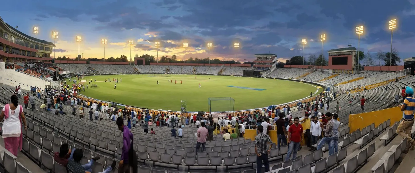
Sport gives the tehsil two international stages. The Punjab Cricket Association IS Bindra Stadium, home of the Punjab Kings franchise, holds about 30,000 spectators; its floodlight pillars are set unusually low so aircraft using the nearby airport do not strike them, and the N Choe stream passes alongside the ground. The city also has an International Hockey Stadium in Phase 9. A newer international cricket stadium has since opened at Mullanpur, in Kharar tehsil.
Shaheed Bhagat Singh International Airport stands inside this tehsil, near Aerocity: the runway lies in Chandigarh while the international terminal sits at Jhiurheri village in Mohali, which is why careful accounts say the airport serves Chandigarh but stands in Punjab. Mohali railway station, in Industrial Area Phase 11, links the city to Delhi, Ludhiana and Amritsar. Politically the city gives its name to the SAS Nagar assembly constituency, number 53, inside the Anandpur Sahib Lok Sabha constituency.
ਐਸ ਏ ਐਸ ਨਗਰ ਤਹਿਸੀਲ ਕਿੱਥੇ ਹੈ?
ਐਸ ਏ ਐਸ ਨਗਰ ਤਹਿਸੀਲ ਭਾਰਤ ਦੇ ਪੰਜਾਬ ਸੂਬੇ ਦੇ ਮਾਲਵਾ ਖੇਤਰ ਵਿੱਚ ਐਸ ਏ ਐਸ ਨਗਰ ਜ਼ਿਲ੍ਹੇ ਦੀ ਇੱਕ ਤਹਿਸੀਲ ਹੈ, ਜਿਸ ਦਾ ਸਦਰ ਮੁਕਾਮ ਯੋਜਨਾਬੱਧ ਸ਼ਹਿਰ ਮੋਹਾਲੀ ਹੈ, ਜੋ ਚੰਡੀਗੜ੍ਹ ਦੇ ਠੀਕ ਪੱਛਮ ਵੱਲ ਪੈਂਦਾ ਹੈ। 2011 ਦੀ ਮਰਦਮਸ਼ੁਮਾਰੀ ਵਿੱਚ ਇਸ ਵਿੱਚ ਸ਼ਿਵਾਲਿਕ ਪਹਾੜੀਆਂ ਦੇ ਪੈਰਾਂ ਕੋਲ 187.43 ਵਰਗ ਕਿਲੋਮੀਟਰ ਵਿੱਚ 85 ਪਿੰਡਾਂ ਅਤੇ ਚਾਰ ਕਸਬਿਆਂ ਵਿੱਚ 324,375 ਲੋਕ ਸਨ।
ਤਹਿਸੀਲ ਆਪਣੇ ਜ਼ਿਲ੍ਹੇ ਦੀਆਂ ਤਿੰਨ ਤਹਿਸੀਲਾਂ ਵਿੱਚੋਂ ਦੱਖਣੀ ਅਤੇ ਸਭ ਤੋਂ ਸ਼ਹਿਰੀ ਹੈ, ਉੱਤਰ ਪੱਛਮ ਵੱਲ ਖਰੜ ਅਤੇ ਪੂਰਬ ਵੱਲ ਡੇਰਾ ਬੱਸੀ ਨਾਲ। ਪੰਜਾਬ ਅਤੇ ਹਰਿਆਣਾ ਦੀ ਸਾਂਝੀ ਰਾਜਧਾਨੀ ਚੰਡੀਗੜ੍ਹ ਇਸ ਨੂੰ ਪੂਰਬ ਵੱਲ ਛੂੰਹਦੀ ਹੈ, ਅਤੇ ਮੋਹਾਲੀ ਸ਼ਹਿਰ ਬਿਨਾਂ ਕਿਸੇ ਖਾਲੀ ਥਾਂ ਦੇ ਚੰਡੀਗੜ੍ਹ ਦੇ ਸੈਕਟਰਾਂ ਵਿੱਚ ਰਲ ਜਾਂਦਾ ਹੈ। ਸ਼ਹਿਰ ਦੇ ਦੱਖਣ ਵੱਲ ਤਹਿਸੀਲ ਮਾਨੌਲੀ ਅਤੇ ਲਾਂਡਰਾਂ ਵਰਗੇ ਪਿੰਡਾਂ ਵਿੱਚੋਂ ਲੰਘ ਕੇ ਪੇਂਡੂ ਰਹਿੰਦੀ ਹੈ, ਬਨੂੜ ਦੇ ਪੁਰਾਣੇ ਕਸਬੇ ਤੱਕ, ਜੋ ਚੰਡੀਗੜ੍ਹ ਤੋਂ ਪਟਿਆਲਾ ਰਾਜਮਾਰਗ ਉੱਤੇ ਮੋਹਾਲੀ ਤੋਂ ਲਗਭਗ 22 ਕਿਲੋਮੀਟਰ ਦੱਖਣ ਵੱਲ, ਪਟਿਆਲਾ ਜ਼ਿਲ੍ਹੇ ਦੀ ਹੱਦ ਨੇੜੇ ਹੈ। ਜ਼ਿਲ੍ਹੇ ਦਾ ਪੂਰਾ ਨਾਂ ਸਾਹਿਬਜ਼ਾਦਾ ਅਜੀਤ ਸਿੰਘ ਨਗਰ ਹੈ, ਜੋ ਗੁਰੂ ਗੋਬਿੰਦ ਸਿੰਘ ਜੀ ਦੇ ਵੱਡੇ ਸਾਹਿਬਜ਼ਾਦੇ ਦੇ ਨਾਂ ਉੱਤੇ ਹੈ, ਅਤੇ ਤਹਿਸੀਲ ਅਤੇ ਇਸ ਦਾ ਸਦਰ ਮੁਕਾਮ ਸ਼ਹਿਰ ਉਸੇ ਨਾਂ ਦਾ ਛੋਟਾ ਰੂਪ ਰੱਖਦੇ ਹਨ।
ਇਸ ਪੰਨੇ ਉੱਤੇ ਪਹਿਲਾਂ ਦਿੱਤਾ ਪੁਰਾਣਾ ਅੰਕੜਾ, 2011 ਵਿੱਚ 324,375 ਲੋਕ, ਤਸਦੀਕਸ਼ੁਦਾ ਹੈ: ਮਰਦਮਸ਼ੁਮਾਰੀ ਤਹਿਸੀਲ ਸੂਚੀ ਅਤੇ ਸਿਟੀ ਪੋਪੂਲੇਸ਼ਨ ਵਾਲੀ ਜ਼ਿਲ੍ਹਾ ਸਾਰਣੀ ਇੱਕੋ ਕੁੱਲ ਦਿੰਦੀਆਂ ਹਨ, ਜੋ 210,927 ਸ਼ਹਿਰੀ ਲੋਕਾਂ, 65.03 ਫੀਸਦੀ, ਅਤੇ 113,448 ਪੇਂਡੂ ਲੋਕਾਂ, 34.97 ਫੀਸਦੀ, ਵਿੱਚ ਵੰਡਿਆ ਹੈ, 71,101 ਘਰਾਂ ਵਿੱਚ। ਇਸ ਨਾਲ ਇਹ ਤਹਿਸੀਲ ਇਸ ਗਾਈਡ ਵਿੱਚ ਸਭ ਤੋਂ ਸ਼ਹਿਰੀ ਤਹਿਸੀਲ ਬਣਦੀ ਹੈ: 2011 ਵਿੱਚ ਇਸ ਦੇ ਹਰ ਤਿੰਨ ਵਾਸੀਆਂ ਵਿੱਚੋਂ ਲਗਭਗ ਦੋ ਇਸ ਦੇ ਕਸਬਿਆਂ ਵਿੱਚ ਰਹਿੰਦੇ ਸਨ, ਮਾਲਵੇ ਦੀਆਂ ਖੇਤੀ ਤਹਿਸੀਲਾਂ ਦੇ ਉਲਟ।
2006 ਵਿੱਚ ਬਣਿਆ ਜ਼ਿਲ੍ਹਾ ਅਤੇ 1975 ਵਿੱਚ ਬਣਿਆ ਸ਼ਹਿਰ
ਜ਼ਿਲ੍ਹਾ ਪੰਜਾਬ ਦੇ ਸਭ ਤੋਂ ਨਵੇਂ ਜ਼ਿਲ੍ਹਿਆਂ ਵਿੱਚੋਂ ਇੱਕ ਹੈ। ਇਹ ਰੋਪੜ ਜ਼ਿਲ੍ਹੇ ਅਤੇ ਪਟਿਆਲਾ ਜ਼ਿਲ੍ਹੇ ਵਿੱਚ ਪੈਂਦੇ ਇਲਾਕਿਆਂ ਨੂੰ ਕੱਟ ਕੇ 14 ਅਪਰੈਲ 2006 ਨੂੰ ਪੰਜਾਬ ਦੇ 18ਵੇਂ ਜ਼ਿਲ੍ਹੇ ਵਜੋਂ, ਰੂਪਨਗਰ ਡਿਵੀਜ਼ਨ ਵਿੱਚ, ਬਣਾਇਆ ਗਿਆ ਸੀ। ਜ਼ਿਲ੍ਹਾ ਪ੍ਰਸ਼ਾਸਨ ਕਾਰਨ ਸਾਫ਼ ਦੱਸਦਾ ਹੈ: ਚੰਡੀਗੜ੍ਹ ਨਾਲ ਲੱਗਦਾ ਇਹ ਇਲਾਕਾ ਉੱਤਰੀ ਭਾਰਤ ਦਾ ਵੱਡਾ ਸੂਚਨਾ ਤਕਨਾਲੋਜੀ ਕੇਂਦਰ ਬਣ ਰਿਹਾ ਸੀ, ਅਤੇ ਉਸ ਵਾਧੇ ਨੂੰ ਸੰਭਾਲਣ ਲਈ ਵੱਖਰਾ ਜ਼ਿਲ੍ਹਾ ਬਣਾਇਆ ਗਿਆ। 2006 ਤੋਂ ਪਹਿਲਾਂ ਇਹ ਧਰਤੀ ਰੋਪੜ ਤੋਂ ਚਲਾਈ ਜਾਂਦੀ ਸੀ, ਅਤੇ ਪੁਰਾਣੇ ਰਿਕਾਰਡ, ਪਿੰਡ ਡਾਇਰੈਕਟਰੀ ਦੇ ਕੁਝ ਹਿੱਸਿਆਂ ਸਮੇਤ, ਇਸ ਦੇ ਪਿੰਡਾਂ ਨੂੰ ਅਜੇ ਮਾਤਾ ਜ਼ਿਲ੍ਹਿਆਂ ਹੇਠ ਦਰਜ ਕਰਦੇ ਹਨ।
ਸਦਰ ਮੁਕਾਮ ਸ਼ਹਿਰ ਆਪਣੇ ਜ਼ਿਲ੍ਹੇ ਤੋਂ ਪੁਰਾਣਾ ਹੈ। ਚੰਡੀਗੜ੍ਹ ਦੇ ਕੇਂਦਰ ਸ਼ਾਸਿਤ ਪ੍ਰਦੇਸ਼ ਬਣਨ ਤੋਂ ਬਾਅਦ ਪੰਜਾਬ ਨੇ ਮੋਹਾਲੀ ਪਿੰਡ ਅਤੇ ਇਸ ਦੇ ਗੁਆਂਢੀਆਂ ਵਾਲੀ ਥਾਂ ਉੱਤੇ ਇਸ ਨਾਲ ਲੱਗਦਾ ਸੈਟੇਲਾਈਟ ਕਸਬਾ ਯੋਜਨਾਬੱਧ ਕੀਤਾ। ਉਦਯੋਗਿਕ ਅਸਟੇਟ ਵਾਲਾ ਪੜਾਅ 1967 ਵਿੱਚ ਸ਼ੁਰੂ ਹੋਇਆ, ਅਤੇ 1 ਨਵੰਬਰ 1975 ਨੂੰ ਪੰਜਾਬ ਦੇ ਮੁੱਖ ਮੰਤਰੀ ਗਿਆਨੀ ਜ਼ੈਲ ਸਿੰਘ ਨੇ ਕਸਬੇ ਦਾ ਨੀਂਹ ਪੱਥਰ ਰੱਖਿਆ ਅਤੇ ਇਸ ਦਾ ਨਾਂ ਸਾਹਿਬਜ਼ਾਦਾ ਅਜੀਤ ਸਿੰਘ ਨਗਰ ਰੱਖਿਆ। ਸ਼ਹਿਰ ਦਾ ਨਾਂ 2012 ਵਿੱਚ ਕੇਂਦਰ ਸਰਕਾਰ ਨੇ ਅਜੀਤਗੜ੍ਹ ਕਰ ਦਿੱਤਾ ਸੀ, ਜੋ ਤਬਦੀਲੀ ਬਾਅਦ ਵਿੱਚ ਵਾਪਸ ਲੈ ਲਈ ਗਈ, ਅਤੇ ਜ਼ਿਆਦਾਤਰ ਲੋਕ ਅਜੇ ਇਸ ਨੂੰ ਸਿਰਫ਼ ਮੋਹਾਲੀ ਹੀ ਕਹਿੰਦੇ ਹਨ। ਤਹਿਸੀਲ ਆਪਣੀ ਕੰਮਕਾਜੀ ਸ਼ਕਲ ਇਸ ਦੋਹਰੇ ਵਾਧੇ ਤੋਂ ਲੈਂਦੀ ਹੈ: ਉੱਤਰ ਵਿੱਚ ਯੋਜਨਾਬੱਧ ਸੈਕਟਰ ਸ਼ਹਿਰ ਅਤੇ ਦੱਖਣ ਵਿੱਚ ਪਿੰਡਾਂ ਅਤੇ ਮੁਗਲ ਕਾਲ ਦੇ ਬਨੂੜ ਕਸਬੇ ਵਾਲਾ ਕਿਤੇ ਪੁਰਾਣਾ ਪੇਂਡੂ ਇਲਾਕਾ।
ਸਦਰ ਮੁਕਾਮ ਸ਼ਹਿਰ ਮੋਹਾਲੀ
ਮੋਹਾਲੀ ਸ਼ਹਿਰ ਇੱਕ ਨਗਰ ਨਿਗਮ ਹੈ ਅਤੇ ਤਹਿਸੀਲ ਅਤੇ ਜ਼ਿਲ੍ਹੇ ਦੋਵਾਂ ਦਾ ਪ੍ਰਸ਼ਾਸਕੀ ਸਦਰ ਮੁਕਾਮ ਹੈ। ਇਸ ਦੇ ਸ਼ਹਿਰੀ ਸਮੂਹ ਨੇ 2011 ਦੀ ਮਰਦਮਸ਼ੁਮਾਰੀ ਵਿੱਚ 176,152 ਲੋਕ ਗਿਣੇ, 93.04 ਫੀਸਦੀ ਦੀ ਅਸਲ ਸਾਖਰਤਾ ਦਰ ਅਤੇ ਹਰ 1,000 ਮਰਦਾਂ ਪਿੱਛੇ 906 ਔਰਤਾਂ ਦੇ ਲਿੰਗ ਅਨੁਪਾਤ ਨਾਲ। ਸ਼ਹਿਰ ਚੰਡੀਗੜ੍ਹ ਦੇ ਵਿਸਤਾਰ ਵਜੋਂ ਉਸੇ ਸੈਕਟਰ ਜਾਲ ਉੱਤੇ ਵਸਾਇਆ ਗਿਆ ਸੀ, ਲਗਭਗ 800 ਗੁਣਾ 1,200 ਮੀਟਰ ਵਾਲਾ: ਇਸ ਦੇ ਪਹਿਲੇ ਗਿਆਰਾਂ ਸੈਕਟਰਾਂ ਨੂੰ ਅਜੇ ਫੇਜ਼ ਕਿਹਾ ਜਾਂਦਾ ਹੈ, ਫੇਜ਼ 1 ਸੈਕਟਰ 55 ਹੈ, ਅਤੇ 63 ਤੋਂ ਉੱਪਰ ਵਾਲੇ ਸੈਕਟਰ ਮੋਹਾਲੀ ਅੰਦਰ ਪੈਂਦੇ ਹਨ। ਚੰਡੀਗੜ੍ਹ ਅਤੇ ਹਰਿਆਣਾ ਦੇ ਪੰਚਕੂਲਾ ਨਾਲ ਮਿਲ ਕੇ ਇਹ ਚੰਡੀਗੜ੍ਹ ਟ੍ਰਾਈਸਿਟੀ ਬਣਾਉਂਦਾ ਹੈ।
ਸ਼ਹਿਰ ਤਹਿਸੀਲ ਦੀ ਸਰਕਾਰ, ਅਦਾਲਤਾਂ ਅਤੇ ਸੇਵਾਵਾਂ ਦਾ ਕੇਂਦਰ ਹੈ, ਅਤੇ ਇਸ ਦਾ ਵਾਧਾ ਇੰਜਣ ਸੂਚਨਾ ਤਕਨਾਲੋਜੀ ਅਤੇ ਉਦਯੋਗ ਹੈ। ਜ਼ਿਲ੍ਹਾ ਬਿਰਤਾਂਤ ਇਸ ਇਲਾਕੇ ਨੂੰ ਉੱਤਰੀ ਭਾਰਤ ਦਾ ਵੱਡਾ ਆਈ ਟੀ ਕੇਂਦਰ ਕਹਿੰਦਾ ਹੈ, ਅਤੇ ਸ਼ਹਿਰ ਵਾਲੇ ਪੰਨੇ ਕੁਆਰਕਸਿਟੀ ਵਿਸ਼ੇਸ਼ ਆਰਥਿਕ ਖੇਤਰ, ਸੈਕਟਰ 82, 82ਏ ਅਤੇ 83ਏ ਦੁਆਲੇ ਲਗਭਗ 1,600 ਏਕੜ ਦਾ ਆਈ ਟੀ ਸਿਟੀ ਵਿਕਾਸ, ਅਤੇ ਤਹਿਸੀਲ ਅੰਦਰ ਬੈਠਦੀਆਂ ਕੌਮੀ ਸੰਸਥਾਵਾਂ ਦਰਜ ਕਰਦੇ ਹਨ: ਸੈਕਟਰ 81 ਵਿੱਚ ਇੰਡੀਅਨ ਸਕੂਲ ਆਫ਼ ਬਿਜ਼ਨਸ, ਇੰਡੀਅਨ ਇੰਸਟੀਚਿਊਟ ਆਫ਼ ਸਾਇੰਸ ਐਜੂਕੇਸ਼ਨ ਐਂਡ ਰਿਸਰਚ, ਅਤੇ ਨੈਸ਼ਨਲ ਇੰਸਟੀਚਿਊਟ ਆਫ਼ ਫਾਰਮਾਸਿਊਟੀਕਲ ਐਜੂਕੇਸ਼ਨ ਐਂਡ ਰਿਸਰਚ। ਸ਼ਹਿਰ 316 ਮੀਟਰ ਉਚਾਈ ਉੱਤੇ ਖੜ੍ਹਾ ਹੈ ਅਤੇ ਵਾਹਨ ਰਜਿਸਟਰੇਸ਼ਨ PB-65 ਵਰਤਦਾ ਹੈ।
ਤਹਿਸੀਲ ਦੇ ਪਿੰਡ, ਬਲਾਕ ਅਤੇ ਲੋਕ
ਤਹਿਸੀਲ ਹੇਠਾਂ, 2011 ਦੀ ਮਰਦਮਸ਼ੁਮਾਰੀ ਪਿੰਡ ਡਾਇਰੈਕਟਰੀ, ਉਪ ਜ਼ਿਲ੍ਹਾ ਕੋਡ 00267, 85 ਪਿੰਡ ਰਿਕਾਰਡ ਦਰਜ ਕਰਦੀ ਹੈ, ਜਿਹਨਾਂ ਵਿੱਚੋਂ 82 ਵੱਸੇ ਹੋਏ ਹਨ, ਜੋ 19,730 ਹੈਕਟੇਅਰ ਉੱਤੇ 22,022 ਘਰਾਂ ਵਿੱਚ ਪੇਂਡੂ 113,448 ਲੋਕ ਰੱਖਦੇ ਹਨ, ਲਗਭਗ 82 ਗ੍ਰਾਮ ਪੰਚਾਇਤਾਂ ਨਾਲ: ਡਾਇਰੈਕਟਰੀ ਦਾ ਸਾਰ 82 ਪੰਚਾਇਤਾਂ ਗਿਣਦਾ ਹੈ ਜਦਕਿ ਇਸ ਦਾ ਆਪਣਾ ਮੁੱਖ ਤੱਥ ਬਕਸਾ 83 ਕਹਿੰਦਾ ਹੈ, ਅਤੇ ਇਹ ਪੰਨਾ ਸਾਰ ਵਾਲਾ ਅੰਕੜਾ ਦਿੰਦਾ ਹੈ। ਡਾਇਰੈਕਟਰੀ ਵਿੱਚ ਹਰ ਵੱਸੇ ਹੋਏ ਪਿੰਡ ਵਿੱਚ ਪ੍ਰਾਇਮਰੀ ਸਕੂਲ, ਮੋਬਾਈਲ ਕਵਰੇਜ ਅਤੇ ਘਰੇਲੂ ਬਿਜਲੀ ਸੀ, ਅਤੇ 43 ਵਿੱਚ ਹਰ ਮੌਸਮ ਵਾਲੀ ਸੜਕ ਸੀ। ਸਭ ਤੋਂ ਵੱਡਾ ਪਿੰਡ ਬੜ ਮਾਜਰਾ ਹੈ, 7,031 ਲੋਕ, ਇਸ ਤੋਂ ਬਾਅਦ ਜਗਤਪੁਰ 6,673 ਅਤੇ ਬਹਿਲੋਲਪੁਰ 5,153 ਨਾਲ; ਖੇਤਰ ਪੱਖੋਂ ਸਭ ਤੋਂ ਵੱਡਾ ਬਾੜੀ ਹੈ, 916 ਹੈਕਟੇਅਰ। ਉੱਤਰੀ ਪਿੰਡਾਂ ਵਿੱਚੋਂ ਕਈ, ਬਕਰਪੁਰ, ਦਾਊਂ ਅਤੇ ਲਾਂਡਰਾਂ ਸਮੇਤ, ਹੁਣ ਗ੍ਰੇਟਰ ਮੋਹਾਲੀ ਵਿਕਾਸ ਖੇਤਰ ਅੰਦਰ ਜਾਂ ਇਸ ਦੇ ਨਾਲ ਹਨ, ਇਸ ਲਈ 2011 ਵਾਲਾ ਪੇਂਡੂ ਢਾਂਚਾ ਜ਼ਮੀਨ ਉੱਤੇ ਘਟਦਾ ਰਿਹਾ ਹੈ।
ਬਲਾਕਾਂ ਦੇ ਨਾਂਵਾਂ ਵਿੱਚ ਇੱਥੇ ਵੀ ਉਹੀ ਸਾਵਧਾਨੀ ਚਾਹੀਦੀ ਹੈ ਜੋ ਪੰਜਾਬ ਵਿੱਚ ਹੋਰ ਥਾਂਵਾਂ ਉੱਤੇ ਚਾਹੀਦੀ ਹੈ, ਕਿਉਂਕਿ ਦੋ ਢਾਂਚੇ ਵਰਤੋਂ ਵਿੱਚ ਹਨ। 2011 ਦੀ ਮਰਦਮਸ਼ੁਮਾਰੀ ਢਾਂਚੇ ਵਿੱਚ ਤਹਿਸੀਲ ਦੇ ਪਿੰਡ ਤਿੰਨ ਭਾਈਚਾਰਕ ਵਿਕਾਸ ਬਲਾਕਾਂ, ਖਰੜ, ਮਾਜਰੀ ਅਤੇ ਰਾਜਪੁਰਾ ਵਿੱਚ ਬੈਠਦੇ ਹਨ, ਅਤੇ ਰਾਜਪੁਰਾ ਬਲਾਕ ਦਾ ਸਿਰਫ਼ ਇੱਕ ਹਿੱਸਾ ਇਸ ਜ਼ਿਲ੍ਹੇ ਵਿੱਚ ਪੈਂਦਾ ਹੈ, ਬਾਕੀ ਪਟਿਆਲਾ ਜ਼ਿਲ੍ਹੇ ਵਿੱਚ। ਸਾਰੇ ਜ਼ਿਲ੍ਹੇ ਵਿੱਚ ਮਰਦਮਸ਼ੁਮਾਰੀ ਢਾਂਚੇ ਵਿੱਚ ਚਾਰ ਬਲਾਕ ਹਨ, ਡੇਰਾ ਬੱਸੀ, ਖਰੜ, ਮਾਜਰੀ ਅਤੇ ਰਾਜਪੁਰਾ, ਜਦਕਿ ਸਰਕਾਰੀ ਏਕੀਕ੍ਰਿਤ ਡਾਇਰੈਕਟਰੀ ਜ਼ਿਲ੍ਹੇ ਦੇ ਬਲਾਕ ਡੇਰਾ ਬੱਸੀ, ਖਰੜ, ਮਾਜਰੀ ਅਤੇ ਮੋਹਾਲੀ ਦਰਜ ਕਰਦੀ ਹੈ। ਇਹ ਪੰਨਾ ਹਰ ਢਾਂਚੇ ਨੂੰ ਉਸ ਦੇ ਆਪਣੇ ਨਾਂ ਹੇਠ ਰੱਖਦਾ ਹੈ ਅਤੇ ਉਹਨਾਂ ਨੂੰ ਕਦੇ ਰਲਾਉਂਦਾ ਨਹੀਂ।
ਤਹਿਸੀਲ ਦਾ ਲਿੰਗ ਅਨੁਪਾਤ 2011 ਵਿੱਚ ਹਰ 1,000 ਮਰਦਾਂ ਪਿੱਛੇ 887 ਔਰਤਾਂ ਸੀ, ਸ਼ਹਿਰੀ 901 ਅਤੇ ਪੇਂਡੂ 862, ਅਤੇ 0 ਤੋਂ 6 ਸਾਲ ਦੇ ਬੱਚੇ 35,814 ਸਨ, ਜਾਂ 11.04 ਫੀਸਦੀ, 856 ਦੇ ਬਾਲ ਲਿੰਗ ਅਨੁਪਾਤ ਨਾਲ। ਅਨੁਸੂਚਿਤ ਜਾਤੀਆਂ 57,253 ਲੋਕ ਸਨ, 17.65 ਫੀਸਦੀ, ਕੋਈ ਅਨੁਸੂਚਿਤ ਕਬੀਲਾ ਆਬਾਦੀ ਦਰਜ ਨਹੀਂ। ਲਗਭਗ 120,676 ਲੋਕ, 37.2 ਫੀਸਦੀ, ਕਾਮੇ ਸਨ। ਸਾਖਰਤਾ ਤਹਿਸੀਲ ਦੀ ਤਾਕਤ ਹੈ: ਅਸਲ ਸਾਖਰਤਾ ਦਰ 86.24 ਫੀਸਦੀ ਸੀ, ਮਰਦ 89.57 ਅਤੇ ਔਰਤ 82.51, ਕਸਬਿਆਂ ਵਿੱਚ 89.91 ਫੀਸਦੀ ਤੱਕ ਜਾ ਕੇ ਅਤੇ ਪਿੰਡਾਂ ਵਿੱਚ 79.27 ਫੀਸਦੀ ਉੱਤੇ ਖੜ੍ਹੀ। ਧਰਮ ਪੱਖੋਂ ਸਿੱਖ 53.71 ਫੀਸਦੀ, 174,208 ਲੋਕ, ਅਤੇ ਹਿੰਦੂ 42.71 ਫੀਸਦੀ, 138,539 ਲੋਕ ਸਨ, ਮੁਸਲਮਾਨ 2.57 ਫੀਸਦੀ ਅਤੇ ਈਸਾਈ 0.54 ਫੀਸਦੀ ਨਾਲ। ਤਹਿਸੀਲ ਦੀ ਭਾਸ਼ਾ ਪੰਜਾਬੀ ਹੈ, ਇਸ ਦੇ ਪੁਆਧੀ ਖੇਤਰੀ ਰੂਪ ਵਿੱਚ: ਜ਼ਿਲ੍ਹਾ ਪੱਧਰ ਉੱਤੇ, ਇੱਥੇ ਜ਼ਿਲ੍ਹਾ ਅੰਕੜੇ ਵਜੋਂ ਦਰਜ ਕਰ ਕੇ, 2011 ਵਿੱਚ 74.72 ਫੀਸਦੀ ਨੇ ਪੰਜਾਬੀ ਨੂੰ ਆਪਣੀ ਪਹਿਲੀ ਭਾਸ਼ਾ ਦੱਸਿਆ ਅਤੇ 22.42 ਫੀਸਦੀ ਨੇ ਹਿੰਦੀ।
ਅਸਥਾਨ, ਫਤਹਿ ਬੁਰਜ ਅਤੇ ਬਨੂੜ ਅਤੇ ਸੋਹਾਣਾ ਕਸਬੇ
ਛੱਪੜ ਛਿੜੀ ਪਿੰਡ ਵਿੱਚ, ਸ਼ਹਿਰ ਦੇ ਠੀਕ ਬਾਹਰ, ਫਤਹਿ ਬੁਰਜ ਖੜ੍ਹਾ ਹੈ, 328 ਫੁੱਟ ਜਾਂ 100 ਮੀਟਰ ਨਾਲ ਭਾਰਤ ਦਾ ਸਭ ਤੋਂ ਉੱਚਾ ਜਿੱਤ ਮੀਨਾਰ, ਜੋ 2011 ਵਿੱਚ ਪੂਰਾ ਹੋਇਆ। ਇਹ 1710 ਦੀ ਛੱਪੜ ਛਿੜੀ ਦੀ ਜੰਗ ਨੂੰ ਦਰਸਾਉਂਦਾ ਹੈ, ਜਿੱਥੇ ਬੰਦਾ ਸਿੰਘ ਬਹਾਦਰ ਨੇ ਸਰਹਿੰਦ ਜਾਂਦੇ ਰਾਹ ਉੱਤੇ ਸਰਹਿੰਦ ਦੇ ਮੁਗਲ ਕਮਾਂਡਰ ਵਜ਼ੀਰ ਖਾਨ ਨੂੰ ਹਰਾਇਆ ਸੀ, ਅਤੇ ਇਹ 1711 ਵਿੱਚ ਪੰਜਾਬ ਦੇ ਵੱਡੇ ਹਿੱਸੇ ਵਿੱਚ ਸਿੱਖ ਰਾਜ ਦੀ ਸਥਾਪਨਾ ਨੂੰ ਸਮਰਪਿਤ ਹੈ। ਪਿੰਡ ਡਾਇਰੈਕਟਰੀ ਬਸਤੀ ਨੂੰ ਛੋਟੀ ਸਪੈਲਿੰਗ ਹੇਠ ਦੋ ਰਿਕਾਰਡਾਂ ਵਜੋਂ ਦਰਜ ਕਰਦੀ ਹੈ, ਛਾਪਰ ਛਿੜੀ ਕਲਾਂ, 343 ਲੋਕ, ਅਤੇ ਛਾਪਰ ਛਿੜੀ ਖੁਰਦ, 706 ਲੋਕ। ਸ਼ਹਿਰ ਅੰਦਰ, ਸੈਕਟਰ 62 ਵਿੱਚ ਗੁਰਦੁਆਰਾ ਅੰਬ ਸਾਹਿਬ ਗੁਰੂ ਹਰਿ ਰਾਇ ਜੀ ਦੀ ਫੇਰੀ ਅਤੇ ਭਾਈ ਕੂਰਮ ਨਾਲ ਉਹਨਾਂ ਦੀ ਮੁਲਾਕਾਤ ਦੀ ਯਾਦ ਦਿਵਾਉਂਦਾ ਹੈ, ਅਤੇ ਸੋਹਾਣਾ ਵਿੱਚ ਗੁਰਦੁਆਰਾ ਸਿੰਘ ਸ਼ਹੀਦਾਂ ਖੜ੍ਹਾ ਹੈ, ਜੋ ਜਥੇਦਾਰ ਬਾਬਾ ਹਨੂੰਮਾਨ ਸਿੰਘ ਅਤੇ ਐਂਗਲੋ ਸਿੱਖ ਜੰਗਾਂ ਵਿੱਚ ਅੰਗਰੇਜ਼ ਫੌਜਾਂ ਨਾਲ ਲੜ ਕੇ ਉੱਥੇ ਸ਼ਹੀਦ ਹੋਏ 500 ਸਿੱਖਾਂ ਦੀ ਯਾਦ ਵਿੱਚ ਬਣਿਆ ਹੈ।
ਤਹਿਸੀਲ ਵਿੱਚ 2011 ਦੀ ਮਰਦਮਸ਼ੁਮਾਰੀ ਢਾਂਚੇ ਵਿੱਚ ਚਾਰ ਕਸਬੇ ਹਨ। ਮੋਹਾਲੀ ਸ਼ਹਿਰ ਤੋਂ ਬਾਅਦ ਦੂਜਾ ਕਸਬਾ ਬਨੂੜ ਹੈ, 2011 ਵਿੱਚ 3,639 ਘਰਾਂ ਵਿੱਚ 18,775 ਲੋਕਾਂ ਵਾਲਾ ਨਗਰ ਕੌਂਸਲ ਕਸਬਾ, ਮੋਹਾਲੀ ਤੋਂ ਲਗਭਗ 22 ਕਿਲੋਮੀਟਰ ਦੱਖਣ ਅਤੇ ਰਾਜਪੁਰੇ ਤੋਂ 12 ਕਿਲੋਮੀਟਰ ਉੱਤਰ ਵੱਲ, ਪਿੰਨ 140601 ਨਾਲ। ਬਨੂੜ ਇੱਕ ਵੱਡਾ ਮੁਗਲ ਕਾਲ ਦਾ ਕਸਬਾ ਅਤੇ ਤਾਓਣੀ ਰਾਜਪੂਤਾਂ ਦੀ ਸੀਟ ਸੀ; 1709 ਵਿੱਚ ਬੰਦਾ ਸਿੰਘ ਬਹਾਦਰ ਨੇ ਸਰਹਿੰਦ ਜਾਂਦੇ ਹੋਏ ਇਸ ਨੂੰ ਢਾਹਿਆ ਸੀ। ਇਹ ਮਾਈ ਬੰਨੋ ਅਤੇ ਸ਼ੀਤਲਾ ਮਾਤਾ ਸਮੇਤ ਪੁਰਾਣੇ ਮੰਦਰ ਰੱਖਦਾ ਹੈ, ਹਰ ਸਾਲ ਤਿੰਨ ਦਿਨਾਂ ਦਾ ਗੁੱਗਾ ਮਾੜੀ ਮੇਲਾ ਲਾਉਂਦਾ ਹੈ, ਅਤੇ ਜੈਨ ਪਰੰਪਰਾ ਵਿੱਚ ਆਤਮਾ ਰਾਮ ਜੀ ਮਹਾਰਾਜ ਦੇ ਦੀਖਸ਼ਾ ਸਥਾਨ ਵਜੋਂ ਯਾਦ ਕੀਤਾ ਜਾਂਦਾ ਹੈ। ਤੀਜਾ ਨਾਂ ਵਾਲਾ ਕਸਬਾ ਸੋਹਾਣਾ ਹੈ, 2011 ਵਿੱਚ 3,677 ਘਰਾਂ ਵਿੱਚ 15,982 ਲੋਕਾਂ ਵਾਲਾ ਮਰਦਮਸ਼ੁਮਾਰੀ ਕਸਬਾ, ਜੋ ਹੁਣ ਸੈਕਟਰ 70 ਕੋਲ ਸ਼ਹਿਰ ਦੇ ਕਿਨਾਰੇ ਵਿੱਚ ਰਲ ਗਿਆ ਹੈ। ਚੌਥਾ ਮਰਦਮਸ਼ੁਮਾਰੀ ਕਸਬਾ ਇਸ ਪੰਨੇ ਲਈ ਖੋਲ੍ਹੇ ਸਰੋਤਾਂ ਵਿੱਚ ਨਾਂ ਨਾਲ ਨਹੀਂ ਦਿੱਤਾ, ਇਸ ਲਈ ਅੰਦਾਜ਼ਾ ਲਾਉਣ ਦੀ ਥਾਂ ਇਸ ਨੂੰ ਇੱਥੇ ਬਿਨਾਂ ਨਾਂ ਦੇ ਛੱਡਿਆ ਗਿਆ ਹੈ।
ਆਈ ਟੀ, ਕ੍ਰਿਕਟ, ਹਵਾਈ ਅੱਡਾ ਅਤੇ ਉੱਥੇ ਕਿਵੇਂ ਪਹੁੰਚੀਏ
ਖੇਡ ਤਹਿਸੀਲ ਨੂੰ ਦੋ ਕੌਮਾਂਤਰੀ ਮੰਚ ਦਿੰਦੀ ਹੈ। ਸ਼ਹਿਰ ਵਿੱਚ ਪੰਜਾਬ ਕ੍ਰਿਕਟ ਐਸੋਸੀਏਸ਼ਨ ਆਈ ਐਸ ਬਿੰਦਰਾ ਸਟੇਡੀਅਮ, ਪੰਜਾਬ ਕਿੰਗਜ਼ ਇੰਡੀਅਨ ਪ੍ਰੀਮੀਅਰ ਲੀਗ ਫਰੈਂਚਾਈਜ਼ੀ ਦਾ ਘਰ, ਲਗਭਗ 30,000 ਦਰਸ਼ਕ ਰੱਖਦਾ ਹੈ; ਇਸ ਦੀਆਂ ਫਲੱਡਲਾਈਟ ਥੰਮ੍ਹ ਆਮ ਨਾਲੋਂ ਨੀਵੇਂ ਰੱਖੇ ਗਏ ਹਨ ਤਾਂ ਜੋ ਨੇੜਲੇ ਹਵਾਈ ਅੱਡੇ ਵਾਲੇ ਜਹਾਜ਼ ਉਹਨਾਂ ਨਾਲ ਨਾ ਟਕਰਾਉਣ, ਅਤੇ ਐਨ ਚੋਅ ਨਾਲਾ ਮੈਦਾਨ ਦੇ ਨਾਲ ਨਾਲ ਲੰਘਦਾ ਹੈ। ਸ਼ਹਿਰ ਵਿੱਚ ਫੇਜ਼ 9 ਵਿੱਚ ਇੱਕ ਕੌਮਾਂਤਰੀ ਹਾਕੀ ਸਟੇਡੀਅਮ ਵੀ ਹੈ, ਜੋ ਪੰਜਾਬ ਵਾਰੀਅਰਜ਼ ਦਾ ਘਰੇਲੂ ਮੈਦਾਨ ਹੈ। ਇਸ ਤੋਂ ਬਾਅਦ ਖਰੜ ਤਹਿਸੀਲ ਦੇ ਮੁੱਲਾਂਪੁਰ ਵਿੱਚ ਦੂਜਾ, ਨਵਾਂ ਕੌਮਾਂਤਰੀ ਕ੍ਰਿਕਟ ਸਟੇਡੀਅਮ ਖੁੱਲ੍ਹ ਗਿਆ ਹੈ, ਇਸ ਲਈ ਪੁਰਾਣਾ ਸਟੇਡੀਅਮ ਹੁਣ ਜ਼ਿਲ੍ਹੇ ਦਾ ਇੱਕੋ ਇੱਕ ਕੌਮਾਂਤਰੀ ਮੈਦਾਨ ਨਹੀਂ ਰਿਹਾ।
ਸ਼ਹੀਦ ਭਗਤ ਸਿੰਘ ਕੌਮਾਂਤਰੀ ਹਵਾਈ ਅੱਡਾ ਇਸ ਤਹਿਸੀਲ ਅੰਦਰ ਖੜ੍ਹਾ ਹੈ, ਮੋਹਾਲੀ ਵਿੱਚ ਏਅਰੋਸਿਟੀ ਨੇੜੇ: ਰਨਵੇ ਚੰਡੀਗੜ੍ਹ ਵਿੱਚ ਪੈਂਦਾ ਹੈ ਜਦਕਿ ਕੌਮਾਂਤਰੀ ਟਰਮੀਨਲ ਇਸ ਦੇ ਦੱਖਣ ਵਾਲੇ ਪਾਸੇ, ਮੋਹਾਲੀ ਦੇ ਝਿਊੜਹੇੜੀ ਪਿੰਡ ਵਿੱਚ ਬੈਠਦਾ ਹੈ, ਇਸੇ ਲਈ ਸਾਵਧਾਨ ਬਿਰਤਾਂਤ ਕਹਿੰਦੇ ਹਨ ਕਿ ਹਵਾਈ ਅੱਡਾ ਚੰਡੀਗੜ੍ਹ ਦੀ ਸੇਵਾ ਕਰਦਾ ਹੈ ਪਰ ਪੰਜਾਬ ਵਿੱਚ ਖੜ੍ਹਾ ਹੈ। ਮੋਹਾਲੀ ਰੇਲਵੇ ਸਟੇਸ਼ਨ, ਉਦਯੋਗਿਕ ਖੇਤਰ ਫੇਜ਼ 11 ਵਿੱਚ, ਸ਼ਹਿਰ ਨੂੰ ਦਿੱਲੀ, ਲੁਧਿਆਣਾ ਅਤੇ ਅੰਮ੍ਰਿਤਸਰ ਨਾਲ ਜੋੜਦਾ ਹੈ। ਰਾਜਨੀਤੀ ਪੱਖੋਂ ਸ਼ਹਿਰ ਐਸ ਏ ਐਸ ਨਗਰ ਵਿਧਾਨ ਸਭਾ ਹਲਕੇ ਨੂੰ ਆਪਣਾ ਨਾਂ ਦਿੰਦਾ ਹੈ, ਨੰਬਰ 53, ਆਨੰਦਪੁਰ ਸਾਹਿਬ ਲੋਕ ਸਭਾ ਹਲਕੇ ਅੰਦਰ।
Nearby
 ਮੋਹਾਲੀCity, Puadh
 ਸਾਹਿਬਜ਼ਾਦਾ ਅਜੀਤ ਸਿੰਘ ਨਗਰDistrict, Puadh
 ਚੰਡੀਗੜ੍ਹCity, Puadh
 ਖਰੜCity, Puadh
 ਜ਼ੀਰਕਪੁਰCity, Puadh
ਸਰੋਤ (10)
- SAS Nagar (Mohali) Tehsil Population, Census 2011, censusofindia.net (tehsil total 324,375 verified: 171,916 men and 152,459 women, sex ratio 887, children 35,814 or 11.04%, child sex ratio 856, urban 210,927 or 65.03% and rural 113,448 or 34.97%, effective literacy 86.24% with urban 89.91% and rural 79.27%, SC 57,253 or 17.65% and no ST, religion table Sikh 53.71% and Hindu 42.71%, area 187.43 sq km, density 1,731, 85 villages, 4 towns, 71,101 households, 120,676 workers)
- Sahibzada Ajit Singh Nagar District, City Population (district total 994,628 at Census 2011, tehsil table Dera Bassi 340,490, Kharar 329,763 and SAS Nagar Mohali 324,375, district area 1,107 sq km in the geospatial frame, source Registrar General and Census Commissioner)
- About District, District SAS Nagar, Government of Punjab, sasnagar.nic.in (district carved out of Ropar and Patiala as 18th district on 14 April 2006, formed beside Chandigarh as an emerging IT hub of northern India, tehsils Mohali, Kharar and Dera Bassi, Rupnagar division, 383 villages in the district frame used there, block village counts Kharar 138, Majri 116 and Dera Bassi 102, district population 994,628)
- Sas Nagar (Mohali) Sub-district Village Directory, vill.co.in (sub district code 00267: 85 village records, 82 inhabited, 113,448 people, 22,022 households, 19,730 hectares, CD blocks Kharar, Majri and Rajpura, largest village Bar Majra 7,031, largest by area Bari 916 hectares, primary school, mobile coverage and power in all 82 inhabited villages, gram panchayats counted as 82 in the summary and 83 in the key facts box)
- Mohali district, Wikipedia (district formed 14 April 2006 from Ropar and Patiala, headquarters Mohali, three tehsils Dera Bassi, Kharar and SAS Nagar Mohali all with sub divisional status, four census blocks Dera Bassi, Kharar, Majri and Rajpura with Rajpura partly in Patiala, integrated directory blocks Dera Bassi, Kharar, Majri and Mohali, 15 towns district wide, district language Punjabi 74.72% and Hindi 22.42%, tehsil religion table Mohali Sikh 53.71% and Hindu 42.71%, Fateh Burj tallest victory tower)
- Mohali, Wikipedia (headquarters city: planned city south west of Chandigarh, Municipal Corporation, foundation stone 1 November 1975 by Giani Zail Singh, named Sahibzada Ajit Singh Nagar, renamed Ajitgarh in 2012, urban agglomeration 176,152 in 2011, effective literacy 93.04%, sex ratio 906, coordinates 30.699 N 76.693 E, elevation 316 m, PB-65, sector and Phase grid, Tricity, IT City about 1,600 acres, ISB Sector 81, IISER and NIPER, PCA IS Bindra Stadium about 30,000 capacity with low floodlights by the airport and the N Choe alongside, International Hockey Stadium, Gurdwara Amb Sahib Sector 62, Gurdwara Singh Shaheedan at Sohana, Shaheed Bhagat Singh International Airport near Aerocity in Mohali, railway station in Phase 11)
- Banur, Wikipedia (town in SAS Nagar Mohali Tehsil: 18,775 people in 3,639 households at Census 2011, about 22 km south of Mohali and 12 km north of Rajpura on the Chandigarh Patiala highway, PIN 140601, Taoni Rajput seat, reduced by Banda Singh Bahadur in 1709, Mai Banno and Shitla Mata temples, Gugga Mari mela, Jain diksha place of Aatma Ram Ji Maharaj)
- Sohana Town Population, Census 2011, censusindia2011.com (Sohana census town in SAS Nagar Mohali Tehsil: 15,982 people, 8,773 men and 7,209 women, in 3,677 households, children 2,471, sex ratio 822, SC 12.26%)
- Fateh Burj, Wikipedia (victory tower at Chappar Chiri in Mohali district: 328 feet or 100 metres, tallest victory tower in India, established 30 November 2011, dedicated to the establishment of Sikh rule in 1711, Battle of Chappar Chiri 1710 where Banda Singh Bahadur defeated Wazir Khan of Sirhind)
- Groundwater Year Book / District Brochure SAS Nagar, Central Ground Water Board, cgwb.gov.in (district drainage frame read via search only: Ghaggar river system on the Dera Bassi side, Siswan Nadi, Jayanti Devi Ki Rao and Patiali Rao rising in the Shivalik hills and draining the north east of the district; the PDF itself could not be opened in full in this run, and no tehsil fact rests on it alone)
ਜੁਗਤੀ ਮੁਫ਼ਤ ਅਤੇ ਸੁਤੰਤਰ ਹੈ। ਪਾਠਕਾਂ ਦਾ ਸਹਿਯੋਗ ਕੋਸ਼ ਨੂੰ ਵਧਾਉਂਦਾ ਹੈ।
ਸਹਿਯੋਗ