

SAS Nagar District, officially Sahibzada Ajit Singh Nagar district and widely called Mohali district, is a district in the Puadh region of Punjab, India, formed on 14 April 2006 from parts of Rupnagar and Patiala districts. Headquartered at Mohali, the planned tricity city beside Chandigarh, it counted 994,628 people in 2011, more of them in its fifteen towns than in its villages, and it holds Fateh Burj and the tricity international airport.
- ਪੰਜਾਬੀ ਨਾਂ
- ਸਾਹਿਬਜ਼ਾਦਾ ਅਜੀਤ ਸਿੰਘ ਨਗਰ
- ਕਿਸਮ
- ਜ਼ਿਲ੍ਹਾ
- ਜ਼ਿਲ੍ਹਾ
- SAS Nagar (Mohali), officially Sahibzada Ajit Singh Nagar district
- Headquarters
- Mohali (Sahibzada Ajit Singh Nagar), a planned Municipal Corporation city named after Sahibzada Ajit Singh, eldest son of Guru Gobind Singh; township foundation stone laid 1 November 1975
- ਇਲਾਕਾ
- Puadh (south eastern Punjab, between Chandigarh and the Shivalik foothills)
- State
- ਪੰਜਾਬ
All 24 facts
- ਦੇਸ਼
- ਭਾਰਤ
- Formed
- 14 April 2006, as the 18th district of Punjab, in Rupnagar division: Kharar and SAS Nagar tehsils from Rupnagar district and Dera Bassi tehsil from Patiala district
- ਆਬਾਦੀ
- 994,628 in 205,411 households (Census 2011), verified across the census listing, City Population and the district administration page: men 529,253 and women 465,375; urban 544,611 (54.76%) and rural 450,017 (45.24%); children aged 0 to 6 were 115,644 (11.63%)
- Area
- 1,094 sq km in the District Census Handbook abstract (rural 921.97 and urban 172.03); the district article summary prints 1,098 sq km and the City Population record prints 1,107 sq km from geospatial data (frames differ, not merged)
- ਪਿੰਡ
- 419 villages in the Census 2011 frame (census listing: 15 towns and 419 villages); the district administration page currently counts 383 villages and prints block counts of Kharar 138, Majri 116 and Dera Bassi 102 (frames differ, not merged)
- Towns
- 15 towns in Census 2011, 7 statutory towns and 8 census towns: Mohali (Municipal Corporation), Zirakpur (Municipal Council, 95,553 in 2011), Kharar (Municipal Council, 74,460 in 2011), Kurali, Dera Bassi, Banur and Nayagaon among the statutory towns, with census towns including Sohana, Balongi, Mullanpur Garib Dass and Lalru
- Tehsils
- 3 tehsils, all with sub divisional status: Dera Bassi (340,490 people in 2011), Kharar (329,763) and SAS Nagar, Mohali (324,375), summing exactly to the district total 994,628 (City Population, Census 2011)
- Blocks
- 4 community development blocks in the census frame: Dera Bassi, Kharar, Majri and Rajpura, of which only part of Rajpura block is under SAS Nagar district, the rest lying in Patiala district
- Density and sex ratio
- Density 909 people per sq km on the census area of 1,094 sq km (census listing); sex ratio printed as 880 women per 1,000 men in the census listing and 878 in the handbook based district summary (frames differ, not merged); urban sex ratio 890 and rural 868 in the census listing; child sex ratio 842
- ਧਰਮ
- Census 2011: Sikh 48.15% (478,908), Hindu 47.88% (476,276), Muslim 2.96%, Christian 0.54%, with Jain, Buddhist, other and not stated shares under 0.5% combined. By tehsil, Kharar and SAS Nagar were Sikh majority and Dera Bassi Hindu majority (61.38%)
- Literacy
- 83.8% effective literacy aged 7 and above in the census listing (736,575 literate of 878,984 people aged 7+, men 87.89% and women 79.18%; urban 87.77% and rural 78.98%). The district article summary prints 84.9% and the district administration page prints 83.3% (bases and frames differ, not merged)
- Scheduled Castes
- 21.74% of the district, 216,231 people (Census 2011); no Scheduled Tribe population recorded
- Workers
- 355,995 workers, about 35.79% of the population (Census 2011 listing): 283,367 men and 72,628 women
- Growth
- Decadal growth 2001 to 2011 printed as 33.15% in the census table (from 746,987 in 2001 to 994,628 in 2011) and as 32.02% in the district article summary (frames differ, not merged)
- ਭਾਸ਼ਾ
- Punjabi, with the Puadhi dialect locally; Census 2011 first language: Punjabi 74.72% and Hindi 22.42% in the district
- Coordinates
- 30.69 N, 76.72 E (district); headquarters city Mohali at 30.699 N, 76.693 E, elevation 316 m
- Airport
- Shaheed Bhagat Singh International Airport (IATA IXC, ICAO VICG): the international terminal stands at Jhiurheri village in Mohali in this district, operated by Chandigarh International Airport Limited (Airports Authority of India 51%, Punjab through GMADA 24.5%, Haryana 24.5%); new terminal inaugurated 11 September 2015 and operational from 19 October 2015
- ਪ੍ਰਸਿੱਧੀ
- The Punjab side of the Chandigarh tricity: Mohali planned city and its cricket stadium, the IT parks and Aerocity, Fateh Burj at Chappar Chiri, the district airport, and the fast growing towns of Kharar, Zirakpur and Dera Bassi
SAS Nagar district, officially Sahibzada Ajit Singh Nagar district and widely called Mohali district, is the Punjab district of the Chandigarh tricity, formed on 14 April 2006 in the Puadh region of south eastern Punjab. Headquartered at Mohali, it counted 994,628 people in 2011, more of them in towns than in villages.
Where is SAS Nagar District?
SAS Nagar District is in the north east of Punjab, India, wrapped around the south and west sides of Chandigarh at about 30.69 degrees north and 76.72 degrees east. Its neighbours are the Haryana districts of Panchkula and Ambala to the east and south, and the Punjab districts of Rupnagar to the north and Fatehgarh Sahib and Patiala to the west and south. The Shivalik foothills rise along its eastern edge, while the rest is Puadh plain, the Punjabi speaking country between the Sutlej and the Ghaggar. The climate is subtropical, with hot summers, cold winters and monsoon rain.
A district drawn in 2006
The district was created on 14 April 2006 as the 18th district of Punjab, in the Rupnagar division. It was carved from two older districts: the Kharar and SAS Nagar tehsils came from Rupnagar district, and the Dera Bassi tehsil came from Patiala district. The district administration says the new district was formed because the area beside Chandigarh was emerging as a major information technology hub of northern India, and needed an administration of its own to manage that growth. Together with Chandigarh and Panchkula in Haryana, it forms the Chandigarh tricity, and in daily life the three work as one urban area.
The headquarters city is much older than the district. Mohali began as a village whose name means settlement. After Chandigarh became a Union Territory, Punjab planned a township of its own beside it: an industrial estate came first in 1967, housing followed, and on 1 November 1975 Chief Minister Giani Zail Singh laid the township foundation stone and named it Sahibzada Ajit Singh Nagar. The city was laid out as an extension of Chandigarh, on a similar grid of sectors, and its first eleven sectors are still called Phases.
People of the district: the 2011 count
The 2011 census counted 994,628 people in the district, 529,253 men and 465,375 women, in 205,411 households. The split between town and country is the district in one line: 544,611 people, or 54.76 percent, lived in its towns, and 450,017, or 45.24 percent, in its villages, making it one of the most urban districts of Punjab. The three tehsils were closely matched: Dera Bassi counted 340,490 people, Kharar 329,763 and SAS Nagar 324,375, summing exactly to the district total. Children aged 0 to 6 numbered 115,644, or 11.63 percent, and workers numbered 355,995, about 35.79 percent.
The sources do not print every figure the same way, and this page keeps the frames apart rather than merging them. The census area in the District Census Handbook abstract is 1,094 square kilometres, the district article summary prints 1,098, and the City Population record, which uses geospatial area, prints 1,107; density follows the frame, at 909 people per square kilometre on the census area. The sex ratio is printed as 880 women per 1,000 men in the census listing and 878 in the handbook based district summary. Literacy is printed three ways: 83.8 percent in the census listing, counted effectively against the population aged seven and above (men 87.89 percent and women 79.18 percent), 84.9 percent in the district article summary, and 83.3 percent on the district administration page. Decadal growth for 2001 to 2011 is printed as 33.15 percent in the census table and as 32.02 percent in the district article summary.
In faith the district is closely balanced, as the old page said, and the exact census shares confirm it: Sikhs were 48.15 percent in 2011, 478,908 people, and Hindus 47.88 percent, 476,276 people, followed by Muslims at 2.96 percent and Christians at 0.54 percent. The balance shifts by tehsil: Kharar and SAS Nagar were Sikh majority in 2011, while Dera Bassi, down the Delhi road, was Hindu majority at 61.38 percent. Scheduled Castes were 21.74 percent, 216,231 people, with no Scheduled Tribe population recorded. Punjabi was the first language of 74.72 percent of the district in 2011 and Hindi of 22.42 percent, with Puadhi the local dialect.
Mohali and the towns of the district
The census frame counts fifteen towns: seven statutory towns and eight census towns. Mohali itself, a Municipal Corporation city, is the headquarters and the largest urban centre, a planned city of phases and sectors holding the district courts, the cricket and hockey stadiums and the main IT parks. West of it on the Chandigarh to Ludhiana highway, Kharar is a Municipal Council town and tehsil headquarters that counted 74,460 people in 2011, and Kurali, the only town of the Majri block, grows around its industry on the same corridor. Chandigarh University, a private university set up in 2012 under a Punjab act, stands not in Chandigarh at all but at Gharuan village in Kharar tehsil, on the NH 05 highway in this district.
To the south east, in Dera Bassi tehsil, Zirakpur is a Municipal Council town at the foot of the Shivaliks that counted 95,553 people in 2011, the district gateway for traffic coming from Delhi toward Chandigarh. Dera Bassi town itself runs a belt of small industry, chemical paints, steel tubes, plywood and handlooms among it, and Lalru continues the industrial line down the highway. Banur, an old Municipal Council town on the Patiala side, and Nayagaon, a Nagar Panchayat town pressed against Chandigarh, complete the main statutory towns, while census towns such as Sohana and Balongi fill the growing edge of the city. Below the towns, the census frame counts 419 villages; the district administration page currently counts 383 villages, with block counts of Kharar 138, Majri 116 and Dera Bassi 102.
Work, study and sport
Work in the district runs on three legs. The first is information technology and services in Mohali, where the Greater Mohali Area Development Authority has laid out Aerocity beside the airport and an IT City of about 1,600 acres, and where companies such as Quark built large campuses. The second is industry: the older industrial areas of Mohali, the small scale belt of Dera Bassi and Lalru, and units around Kurali and Kharar. The third is village farmland, still Puadhi speaking farming country.
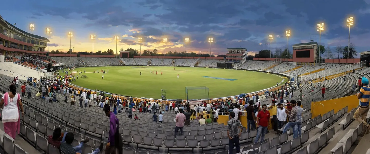
Study is the district's second industry. In Knowledge City, Sector 81 of Mohali, IISER Mohali and the Indian School of Business, ISB, stand in the same knowledge district, and the National Institute of Pharmaceutical Education and Research, NIPER, is also in SAS Nagar. Chandigarh University at Gharuan draws students from across India to Kharar tehsil. Sport gives the district its best known address after the airport: the Punjab Cricket Association stadium in Mohali, home of the Punjab Kings, and the International Hockey Stadium in Phase 9.
Fateh Burj and places of interest
The district's great monument is Fateh Burj, the Victory Tower, at Chappar Chiri village just outside Mohali. At 328 feet, or 100 metres, it is the tallest victory tower in India, completed and inaugurated on 30 November 2011 as the centre of the Baba Banda Singh Bahadur War Memorial. It marks the ground where, in 1710, Banda Singh Bahadur defeated Wazir Khan, the Mughal commander marching to stop the Sikh army on its way to Sirhind, a victory that opened the road to the first Sikh rule in the region. Statues of Banda Singh Bahadur and his generals stand around the tower.
Mohali's own shrines are woven into the phases. Gurdwara Amb Sahib, in Sector 62, remembers the visit of Guru Har Rai, the seventh Guru, and his meeting with his devotee Bhai Kuram. At Sohana village, close to Sector 70, Gurdwara Singh Shaheedan remembers Jathedar Baba Hanuman Singh and the 500 Sikhs who attained martyrdom there against British forces during the Anglo Sikh Wars.
Getting there
The district holds the tricity's airport. Shaheed Bhagat Singh International Airport, IATA code IXC and ICAO code VICG, officially carries Chandigarh's name, but its new international terminal stands at Jhiurheri village in Mohali, in this district, south of the runway it shares with the Indian Air Force. It is run by Chandigarh International Airport Limited, a joint venture of the Airports Authority of India with 51 percent and the Punjab and Haryana governments with 24.5 percent each. The new terminal was inaugurated on 11 September 2015 and became operational on 19 October 2015; travellers should check current flights before relying on a route.
By rail, Mohali railway station, in Industrial Area Phase 11, connects the district with Delhi, Ludhiana and Amritsar, and Chandigarh's own station sits just across the boundary. By road, the Chandigarh to Ludhiana highway, NH 05, runs through Kharar and past Chandigarh University at Gharuan, the Delhi road climbs through Zirakpur and Dera Bassi, and Chandigarh Transport Undertaking buses tie Mohali's phases to Chandigarh's sectors all day.
ਐਸ.ਏ.ਐਸ. ਨਗਰ ਜ਼ਿਲ੍ਹਾ, ਜਿਸ ਦਾ ਅਧਿਕਾਰਤ ਨਾਂ ਸਾਹਿਬਜ਼ਾਦਾ ਅਜੀਤ ਸਿੰਘ ਨਗਰ ਜ਼ਿਲ੍ਹਾ ਹੈ ਅਤੇ ਜਿਸ ਨੂੰ ਆਮ ਤੌਰ ਉੱਤੇ ਮੋਹਾਲੀ ਜ਼ਿਲ੍ਹਾ ਕਿਹਾ ਜਾਂਦਾ ਹੈ, ਚੰਡੀਗੜ੍ਹ ਟ੍ਰਾਈਸਿਟੀ ਦਾ ਪੰਜਾਬ ਵਾਲਾ ਜ਼ਿਲ੍ਹਾ ਹੈ, ਜੋ 14 ਅਪ੍ਰੈਲ 2006 ਨੂੰ ਦੱਖਣ ਪੂਰਬੀ ਪੰਜਾਬ ਦੇ ਪੁਆਧ ਖੇਤਰ ਵਿੱਚ ਬਣਾਇਆ ਗਿਆ ਸੀ। ਇਸ ਦਾ ਸਦਰ ਮੁਕਾਮ ਮੋਹਾਲੀ ਹੈ, ਅਤੇ 2011 ਵਿੱਚ ਇੱਥੇ 994,628 ਲੋਕ ਗਿਣੇ ਗਏ ਸਨ, ਜਿਹਨਾਂ ਵਿੱਚੋਂ ਵੱਧ ਲੋਕ ਪਿੰਡਾਂ ਦੀ ਬਜਾਏ ਕਸਬਿਆਂ ਵਿੱਚ ਰਹਿੰਦੇ ਸਨ।
ਐਸ.ਏ.ਐਸ. ਨਗਰ ਜ਼ਿਲ੍ਹਾ ਕਿੱਥੇ ਹੈ?
ਐਸ.ਏ.ਐਸ. ਨਗਰ ਜ਼ਿਲ੍ਹਾ ਭਾਰਤ ਦੇ ਪੰਜਾਬ ਸੂਬੇ ਦੇ ਉੱਤਰ ਪੂਰਬ ਵਿੱਚ ਹੈ, ਚੰਡੀਗੜ੍ਹ ਦੇ ਦੱਖਣ ਅਤੇ ਪੱਛਮ ਵਾਲੇ ਪਾਸਿਆਂ ਨੂੰ ਘੇਰਦਾ ਹੋਇਆ, ਲਗਭਗ 30.69 ਡਿਗਰੀ ਉੱਤਰ ਅਤੇ 76.72 ਡਿਗਰੀ ਪੂਰਬ ਉੱਤੇ। ਇਸ ਦੇ ਗੁਆਂਢੀ ਪੂਰਬ ਅਤੇ ਦੱਖਣ ਵੱਲ ਹਰਿਆਣੇ ਦੇ ਪੰਚਕੂਲਾ ਅਤੇ ਅੰਬਾਲਾ ਜ਼ਿਲ੍ਹੇ ਹਨ, ਅਤੇ ਉੱਤਰ ਵੱਲ ਪੰਜਾਬ ਦਾ ਰੂਪਨਗਰ ਜ਼ਿਲ੍ਹਾ ਅਤੇ ਪੱਛਮ ਅਤੇ ਦੱਖਣ ਵੱਲ ਫਤਹਿਗੜ੍ਹ ਸਾਹਿਬ ਅਤੇ ਪਟਿਆਲਾ ਜ਼ਿਲ੍ਹੇ। ਸ਼ਿਵਾਲਿਕ ਪਹਾੜੀਆਂ ਇਸ ਦੇ ਪੂਰਬੀ ਕਿਨਾਰੇ ਨਾਲ ਉੱਠਦੀਆਂ ਹਨ, ਜਦਕਿ ਬਾਕੀ ਸਾਰਾ ਇਲਾਕਾ ਪੁਆਧ ਦਾ ਮੈਦਾਨ ਹੈ, ਸਤਲੁਜ ਅਤੇ ਘੱਗਰ ਵਿਚਕਾਰ ਪੰਜਾਬੀ ਬੋਲਣ ਵਾਲਾ ਇਲਾਕਾ। ਮੌਸਮ ਉਪ ਤਪਤ ਖੰਡੀ ਹੈ, ਗਰਮੀਆਂ ਤਪਦੀਆਂ ਹਨ, ਸਰਦੀਆਂ ਠੰਢੀਆਂ ਹੁੰਦੀਆਂ ਹਨ, ਅਤੇ ਜ਼ਿਆਦਾਤਰ ਮੀਂਹ ਮੌਨਸੂਨ ਵਿੱਚ ਪੈਂਦਾ ਹੈ।
2006 ਵਿੱਚ ਬਣਾਇਆ ਗਿਆ ਜ਼ਿਲ੍ਹਾ
ਇਹ ਜ਼ਿਲ੍ਹਾ 14 ਅਪ੍ਰੈਲ 2006 ਨੂੰ ਪੰਜਾਬ ਦੇ 18ਵੇਂ ਜ਼ਿਲ੍ਹੇ ਵਜੋਂ ਬਣਾਇਆ ਗਿਆ ਸੀ, ਅਤੇ ਇਹ ਰੂਪਨਗਰ ਡਿਵੀਜ਼ਨ ਵਿੱਚ ਬੈਠਦਾ ਹੈ। ਇਹ ਦੋ ਪੁਰਾਣੇ ਜ਼ਿਲ੍ਹਿਆਂ ਵਿੱਚੋਂ ਕੱਟ ਕੇ ਬਣਾਇਆ ਗਿਆ ਸੀ, ਖਰੜ ਅਤੇ ਐਸ.ਏ.ਐਸ. ਨਗਰ ਤਹਿਸੀਲਾਂ ਰੂਪਨਗਰ ਜ਼ਿਲ੍ਹੇ ਵਿੱਚੋਂ ਆਈਆਂ, ਅਤੇ ਡੇਰਾ ਬੱਸੀ ਤਹਿਸੀਲ ਪਟਿਆਲਾ ਜ਼ਿਲ੍ਹੇ ਵਿੱਚੋਂ ਆਈ। ਜ਼ਿਲ੍ਹਾ ਪ੍ਰਸ਼ਾਸਨ ਕਹਿੰਦਾ ਹੈ ਕਿ ਨਵਾਂ ਜ਼ਿਲ੍ਹਾ ਇਸ ਲਈ ਬਣਾਇਆ ਗਿਆ ਸੀ ਕਿਉਂਕਿ ਚੰਡੀਗੜ੍ਹ ਨਾਲ ਲੱਗਦਾ ਇਹ ਇਲਾਕਾ ਉੱਤਰੀ ਭਾਰਤ ਦੇ ਵੱਡੇ ਸੂਚਨਾ ਤਕਨਾਲੋਜੀ ਕੇਂਦਰ ਵਜੋਂ ਉੱਭਰ ਰਿਹਾ ਸੀ, ਅਤੇ ਉਸ ਵਾਧੇ ਨੂੰ ਸੰਭਾਲਣ ਲਈ ਇਸ ਨੂੰ ਆਪਣਾ ਪ੍ਰਸ਼ਾਸਨ ਚਾਹੀਦਾ ਸੀ। ਚੰਡੀਗੜ੍ਹ ਅਤੇ ਹਰਿਆਣੇ ਦੇ ਪੰਚਕੂਲਾ ਸਮੇਤ ਇਹ ਚੰਡੀਗੜ੍ਹ ਟ੍ਰਾਈਸਿਟੀ ਬਣਾਉਂਦਾ ਹੈ, ਅਤੇ ਰੋਜ਼ਾਨਾ ਜੀਵਨ ਵਿੱਚ ਤਿੰਨੋਂ ਇੱਕੋ ਸ਼ਹਿਰੀ ਇਲਾਕੇ ਵਾਂਗ ਕੰਮ ਕਰਦੇ ਹਨ।
ਸਦਰ ਮੁਕਾਮ ਸ਼ਹਿਰ ਜ਼ਿਲ੍ਹੇ ਤੋਂ ਕਿਤੇ ਪੁਰਾਣਾ ਹੈ। ਮੋਹਾਲੀ ਇੱਕ ਪਿੰਡ ਵਜੋਂ ਸ਼ੁਰੂ ਹੋਇਆ ਸੀ, ਜਿਸ ਦੇ ਨਾਂ ਦਾ ਅਰਥ ਹੈ ਬਸਤੀ। ਚੰਡੀਗੜ੍ਹ ਦੇ ਕੇਂਦਰ ਸ਼ਾਸਿਤ ਪ੍ਰਦੇਸ਼ ਬਣ ਜਾਣ ਤੋਂ ਬਾਅਦ ਪੰਜਾਬ ਨੇ ਇਸ ਦੇ ਨਾਲ ਆਪਣਾ ਕਸਬਾ ਯੋਜਨਾਬੱਧ ਕੀਤਾ, 1967 ਵਿੱਚ ਪਹਿਲਾਂ ਇੱਕ ਉਦਯੋਗਿਕ ਅਸਟੇਟ ਆਈ, ਫਿਰ ਰਿਹਾਇਸ਼ ਆਈ, ਅਤੇ 1 ਨਵੰਬਰ 1975 ਨੂੰ ਮੁੱਖ ਮੰਤਰੀ ਗਿਆਨੀ ਜੈਲ ਸਿੰਘ ਨੇ ਕਸਬੇ ਦਾ ਨੀਂਹ ਪੱਥਰ ਰੱਖਿਆ ਅਤੇ ਇਸ ਦਾ ਨਾਂ ਸਾਹਿਬਜ਼ਾਦਾ ਅਜੀਤ ਸਿੰਘ ਨਗਰ ਰੱਖਿਆ। ਸ਼ਹਿਰ ਚੰਡੀਗੜ੍ਹ ਦੇ ਵਿਸਥਾਰ ਵਜੋਂ ਬਣਾਇਆ ਗਿਆ ਸੀ, ਸੈਕਟਰਾਂ ਦੇ ਉਸੇ ਤਰ੍ਹਾਂ ਦੇ ਜਾਲ ਉੱਤੇ, ਅਤੇ ਇਸ ਦੇ ਪਹਿਲੇ ਗਿਆਰਾਂ ਸੈਕਟਰਾਂ ਨੂੰ ਅੱਜ ਵੀ ਫੇਜ਼ ਕਿਹਾ ਜਾਂਦਾ ਹੈ, ਫੇਜ਼ 1 ਤੋਂ ਫੇਜ਼ 11 ਤੱਕ।
ਜ਼ਿਲ੍ਹੇ ਦੇ ਲੋਕ: 2011 ਦੀ ਗਿਣਤੀ
2011 ਦੀ ਮਰਦਮਸ਼ੁਮਾਰੀ ਵਿੱਚ ਜ਼ਿਲ੍ਹੇ ਵਿੱਚ 994,628 ਲੋਕ ਗਿਣੇ ਗਏ ਸਨ, 529,253 ਮਰਦ ਅਤੇ 465,375 ਔਰਤਾਂ, 205,411 ਘਰਾਂ ਵਿੱਚ। ਕਸਬੇ ਅਤੇ ਪਿੰਡ ਵਿਚਕਾਰ ਵੰਡ ਇੱਕੋ ਸਤਰ ਵਿੱਚ ਜ਼ਿਲ੍ਹੇ ਨੂੰ ਦੱਸਦੀ ਹੈ, 544,611 ਲੋਕ, ਜਾਂ 54.76 ਫੀਸਦੀ, ਇਸ ਦੇ ਕਸਬਿਆਂ ਵਿੱਚ ਰਹਿੰਦੇ ਸਨ, ਅਤੇ 450,017, ਜਾਂ 45.24 ਫੀਸਦੀ, ਇਸ ਦੇ ਪਿੰਡਾਂ ਵਿੱਚ, ਜਿਸ ਨਾਲ ਇਹ ਪੰਜਾਬ ਦੇ ਸਭ ਤੋਂ ਵੱਧ ਸ਼ਹਿਰੀ ਜ਼ਿਲ੍ਹਿਆਂ ਵਿੱਚੋਂ ਇੱਕ ਬਣਦਾ ਹੈ। ਤਿੰਨੋਂ ਤਹਿਸੀਲਾਂ ਆਕਾਰ ਵਿੱਚ ਨੇੜੇ ਨੇੜੇ ਸਨ, ਡੇਰਾ ਬੱਸੀ ਤਹਿਸੀਲ ਵਿੱਚ 340,490 ਲੋਕ ਗਿਣੇ ਗਏ, ਖਰੜ ਤਹਿਸੀਲ ਵਿੱਚ 329,763 ਅਤੇ ਐਸ.ਏ.ਐਸ. ਨਗਰ ਤਹਿਸੀਲ ਵਿੱਚ 324,375, ਅਤੇ ਤਿੰਨੋਂ ਅੰਕੜੇ ਮਿਲ ਕੇ ਠੀਕ ਜ਼ਿਲ੍ਹੇ ਦੇ ਕੁੱਲ ਬਣਦੇ ਹਨ। 0 ਤੋਂ 6 ਸਾਲ ਦੇ ਬੱਚੇ 115,644 ਸਨ, ਜਾਂ 11.63 ਫੀਸਦੀ, ਅਤੇ ਮਜ਼ਦੂਰ 355,995 ਸਨ, ਆਬਾਦੀ ਦਾ ਲਗਭਗ 35.79 ਫੀਸਦੀ।
ਸਰੋਤ ਹਰ ਅੰਕੜਾ ਇੱਕੋ ਤਰ੍ਹਾਂ ਨਹੀਂ ਛਾਪਦੇ, ਅਤੇ ਇਹ ਪੰਨਾ ਢਾਂਚਿਆਂ ਨੂੰ ਰਲਾਉਣ ਦੀ ਬਜਾਏ ਵੱਖ ਵੱਖ ਰੱਖਦਾ ਹੈ। ਜ਼ਿਲ੍ਹਾ ਮਰਦਮਸ਼ੁਮਾਰੀ ਹੈਂਡਬੁੱਕ ਦੇ ਸਾਰ ਵਿੱਚ ਮਰਦਮਸ਼ੁਮਾਰੀ ਖੇਤਰ 1,094 ਵਰਗ ਕਿਲੋਮੀਟਰ ਹੈ, ਜ਼ਿਲ੍ਹਾ ਲੇਖ ਦਾ ਸਾਰ 1,098 ਛਾਪਦਾ ਹੈ, ਅਤੇ ਸਿਟੀ ਪਾਪੂਲੇਸ਼ਨ ਰਿਕਾਰਡ, ਜੋ ਭੂ ਸਥਾਨਕ ਖੇਤਰ ਵਰਤਦਾ ਹੈ, 1,107 ਛਾਪਦਾ ਹੈ, ਘਣਤਾ ਢਾਂਚੇ ਅਨੁਸਾਰ ਬਦਲਦੀ ਹੈ, ਮਰਦਮਸ਼ੁਮਾਰੀ ਖੇਤਰ ਉੱਤੇ 909 ਲੋਕ ਪ੍ਰਤੀ ਵਰਗ ਕਿਲੋਮੀਟਰ। ਲਿੰਗ ਅਨੁਪਾਤ ਮਰਦਮਸ਼ੁਮਾਰੀ ਸੂਚੀ ਵਿੱਚ ਹਰ 1,000 ਮਰਦਾਂ ਪਿੱਛੇ 880 ਔਰਤਾਂ ਛਪਿਆ ਹੈ ਅਤੇ ਹੈਂਡਬੁੱਕ ਆਧਾਰਿਤ ਜ਼ਿਲ੍ਹਾ ਸਾਰ ਵਿੱਚ 878। ਸਾਖਰਤਾ ਤਿੰਨ ਤਰ੍ਹਾਂ ਛਪੀ ਹੈ, ਮਰਦਮਸ਼ੁਮਾਰੀ ਸੂਚੀ ਵਿੱਚ 83.8 ਫੀਸਦੀ, ਸੱਤ ਸਾਲ ਅਤੇ ਇਸ ਤੋਂ ਵੱਧ ਉਮਰ ਦੀ ਆਬਾਦੀ ਦੇ ਮੁਕਾਬਲੇ ਅਸਰਦਾਰ ਤਰੀਕੇ ਨਾਲ ਗਿਣੀ ਹੋਈ, 878,984 ਲੋਕਾਂ ਵਿੱਚੋਂ 736,575 ਪੜ੍ਹੇ ਲਿਖੇ, ਮਰਦ 87.89 ਫੀਸਦੀ ਅਤੇ ਔਰਤਾਂ 79.18 ਫੀਸਦੀ, ਜ਼ਿਲ੍ਹਾ ਲੇਖ ਦੇ ਸਾਰ ਵਿੱਚ 84.9 ਫੀਸਦੀ, ਅਤੇ ਜ਼ਿਲ੍ਹਾ ਪ੍ਰਸ਼ਾਸਨ ਪੰਨੇ ਉੱਤੇ 83.3 ਫੀਸਦੀ। 2001 ਤੋਂ 2011 ਤੱਕ ਦਹਾਕੇ ਦਾ ਵਾਧਾ ਮਰਦਮਸ਼ੁਮਾਰੀ ਸਾਰਣੀ ਵਿੱਚ 33.15 ਫੀਸਦੀ ਛਪਿਆ ਹੈ, 2001 ਵਿੱਚ 746,987 ਲੋਕਾਂ ਤੋਂ, ਅਤੇ ਜ਼ਿਲ੍ਹਾ ਲੇਖ ਦੇ ਸਾਰ ਵਿੱਚ 32.02 ਫੀਸਦੀ।
ਧਰਮ ਪੱਖੋਂ ਜ਼ਿਲ੍ਹਾ ਨੇੜਿਓਂ ਸੰਤੁਲਿਤ ਹੈ, ਜਿਵੇਂ ਪੁਰਾਣਾ ਪੰਨਾ ਕਹਿੰਦਾ ਸੀ, ਅਤੇ ਠੀਕ ਮਰਦਮਸ਼ੁਮਾਰੀ ਹਿੱਸੇ ਇਸ ਦੀ ਪੁਸ਼ਟੀ ਕਰਦੇ ਹਨ, 2011 ਵਿੱਚ ਸਿੱਖ 48.15 ਫੀਸਦੀ ਸਨ, 478,908 ਲੋਕ, ਅਤੇ ਹਿੰਦੂ 47.88 ਫੀਸਦੀ, 476,276 ਲੋਕ, ਇਸ ਤੋਂ ਬਾਅਦ ਮੁਸਲਮਾਨ 2.96 ਫੀਸਦੀ ਅਤੇ ਈਸਾਈ 0.54 ਫੀਸਦੀ। ਸੰਤੁਲਨ ਤਹਿਸੀਲ ਅਨੁਸਾਰ ਬਦਲਦਾ ਹੈ, 2011 ਵਿੱਚ ਖਰੜ ਅਤੇ ਐਸ.ਏ.ਐਸ. ਨਗਰ ਤਹਿਸੀਲਾਂ ਸਿੱਖ ਬਹੁਗਿਣਤੀ ਸਨ, ਜਦਕਿ ਡੇਰਾ ਬੱਸੀ ਤਹਿਸੀਲ, ਦਿੱਲੀ ਵਾਲੀ ਸੜਕ ਉੱਤੇ, 61.38 ਫੀਸਦੀ ਨਾਲ ਹਿੰਦੂ ਬਹੁਗਿਣਤੀ ਸੀ। ਅਨੁਸੂਚਿਤ ਜਾਤੀਆਂ ਜ਼ਿਲ੍ਹੇ ਦਾ 21.74 ਫੀਸਦੀ ਸਨ, 216,231 ਲੋਕ, ਕੋਈ ਅਨੁਸੂਚਿਤ ਕਬੀਲਾ ਆਬਾਦੀ ਦਰਜ ਨਹੀਂ। 2011 ਵਿੱਚ ਜ਼ਿਲ੍ਹੇ ਦੇ 74.72 ਫੀਸਦੀ ਲੋਕਾਂ ਦੀ ਪਹਿਲੀ ਭਾਸ਼ਾ ਪੰਜਾਬੀ ਸੀ ਅਤੇ 22.42 ਫੀਸਦੀ ਦੀ ਹਿੰਦੀ, ਪੁਆਧੀ ਸਥਾਨਕ ਪੰਜਾਬੀ ਬੋਲੀ ਹੈ।
ਮੋਹਾਲੀ ਅਤੇ ਜ਼ਿਲ੍ਹੇ ਦੇ ਕਸਬੇ
ਮਰਦਮਸ਼ੁਮਾਰੀ ਢਾਂਚਾ ਜ਼ਿਲ੍ਹੇ ਵਿੱਚ ਪੰਦਰਾਂ ਕਸਬੇ ਗਿਣਦਾ ਹੈ, ਸੱਤ ਕਾਨੂੰਨੀ ਕਸਬੇ ਅਤੇ ਅੱਠ ਮਰਦਮਸ਼ੁਮਾਰੀ ਕਸਬੇ। ਮੋਹਾਲੀ ਖ਼ੁਦ, ਇੱਕ ਨਗਰ ਨਿਗਮ ਸ਼ਹਿਰ, ਸਦਰ ਮੁਕਾਮ ਅਤੇ ਸਭ ਤੋਂ ਵੱਡਾ ਸ਼ਹਿਰੀ ਕੇਂਦਰ ਹੈ, ਫੇਜ਼ਾਂ ਅਤੇ ਸੈਕਟਰਾਂ ਦਾ ਯੋਜਨਾਬੱਧ ਸ਼ਹਿਰ, ਜ਼ਿਲ੍ਹਾ ਅਦਾਲਤਾਂ, ਕ੍ਰਿਕਟ ਅਤੇ ਹਾਕੀ ਸਟੇਡੀਅਮ ਅਤੇ ਮੁੱਖ ਆਈਟੀ ਪਾਰਕ ਰੱਖਦਾ ਹੋਇਆ। ਇਸ ਦੇ ਪੱਛਮ ਵੱਲ ਚੰਡੀਗੜ੍ਹ ਤੋਂ ਲੁਧਿਆਣਾ ਹਾਈਵੇ ਉੱਤੇ ਖਰੜ ਇੱਕ ਨਗਰ ਕੌਂਸਲ ਕਸਬਾ ਅਤੇ ਤਹਿਸੀਲ ਸਦਰ ਮੁਕਾਮ ਹੈ, ਜਿਸ ਵਿੱਚ 2011 ਵਿੱਚ 74,460 ਲੋਕ ਗਿਣੇ ਗਏ ਸਨ, ਅਤੇ ਕੁਰਾਲੀ, ਮਾਜਰੀ ਬਲਾਕ ਦਾ ਇਕੱਲਾ ਕਸਬਾ, ਉਸੇ ਗਲਿਆਰੇ ਉੱਤੇ ਆਪਣੇ ਉਦਯੋਗ ਆਲੇ ਦੁਆਲੇ ਵਧਦਾ ਹੈ। ਚੰਡੀਗੜ੍ਹ ਯੂਨੀਵਰਸਿਟੀ, ਪੰਜਾਬ ਦੇ ਕਾਨੂੰਨ ਹੇਠ 2012 ਵਿੱਚ ਸਥਾਪਿਤ ਇੱਕ ਨਿੱਜੀ ਯੂਨੀਵਰਸਿਟੀ, ਚੰਡੀਗੜ੍ਹ ਵਿੱਚ ਬਿਲਕੁਲ ਨਹੀਂ ਹੈ, ਇਹ ਇਸ ਜ਼ਿਲ੍ਹੇ ਵਿੱਚ NH 05 ਹਾਈਵੇ ਉੱਤੇ ਖਰੜ ਤਹਿਸੀਲ ਦੇ ਘੜੂਆਂ ਪਿੰਡ ਵਿੱਚ ਖੜ੍ਹੀ ਹੈ।
ਦੱਖਣ ਪੂਰਬ ਵੱਲ, ਡੇਰਾ ਬੱਸੀ ਤਹਿਸੀਲ ਵਿੱਚ, ਜ਼ੀਰਕਪੁਰ ਸ਼ਿਵਾਲਿਕ ਪਹਾੜੀਆਂ ਦੇ ਪੈਰਾਂ ਵਿੱਚ ਇੱਕ ਨਗਰ ਕੌਂਸਲ ਕਸਬਾ ਹੈ, ਜਿਸ ਵਿੱਚ 2011 ਵਿੱਚ 95,553 ਲੋਕ ਗਿਣੇ ਗਏ ਸਨ, ਚੰਡੀਗੜ੍ਹ ਵੱਲ ਦਿੱਲੀ ਤੋਂ ਆਉਂਦੇ ਟ੍ਰੈਫਿਕ ਲਈ ਜ਼ਿਲ੍ਹੇ ਦਾ ਦਰਵਾਜ਼ਾ। ਡੇਰਾ ਬੱਸੀ ਕਸਬਾ ਖ਼ੁਦ ਛੋਟੇ ਉਦਯੋਗ ਦੀ ਪੱਟੀ ਚਲਾਉਂਦਾ ਹੈ, ਇਸ ਵਿੱਚ ਰਸਾਇਣਕ ਰੰਗ, ਸਟੀਲ ਦੀਆਂ ਨਾਲੀਆਂ, ਪਲਾਈਵੁੱਡ ਅਤੇ ਦਰੀਆਂ ਦੀ ਬੁਣਾਈ ਸ਼ਾਮਲ ਹੈ, ਅਤੇ ਲਾਲੜੂ ਹਾਈਵੇ ਉੱਤੇ ਉਦਯੋਗਿਕ ਲਾਈਨ ਨੂੰ ਅੱਗੇ ਲੈ ਜਾਂਦਾ ਹੈ। ਬਾਨੂੜ, ਪਟਿਆਲਾ ਵਾਲੇ ਪਾਸੇ ਇੱਕ ਪੁਰਾਣਾ ਨਗਰ ਕੌਂਸਲ ਕਸਬਾ, ਅਤੇ ਨਯਾਗਾਉਂ, ਚੰਡੀਗੜ੍ਹ ਨਾਲ ਦੱਬਿਆ ਇੱਕ ਨਗਰ ਪੰਚਾਇਤ ਕਸਬਾ, ਮੁੱਖ ਕਾਨੂੰਨੀ ਕਸਬਿਆਂ ਨੂੰ ਪੂਰਾ ਕਰਦੇ ਹਨ, ਜਦਕਿ ਸੋਹਾਣਾ, ਬਲੌਂਗੀ ਅਤੇ ਮੁੱਲਾਂਪੁਰ ਗਰੀਬ ਦਾਸ ਵਰਗੇ ਮਰਦਮਸ਼ੁਮਾਰੀ ਕਸਬੇ ਸ਼ਹਿਰ ਦੇ ਵਧਦੇ ਕਿਨਾਰੇ ਨੂੰ ਭਰਦੇ ਹਨ। ਕਸਬਿਆਂ ਹੇਠਾਂ, ਮਰਦਮਸ਼ੁਮਾਰੀ ਢਾਂਚਾ 419 ਪਿੰਡ ਗਿਣਦਾ ਹੈ, ਜ਼ਿਲ੍ਹਾ ਪ੍ਰਸ਼ਾਸਨ ਪੰਨਾ ਇਸ ਵੇਲੇ 383 ਪਿੰਡ ਗਿਣਦਾ ਹੈ, ਅਤੇ ਆਪਣੇ ਬਲਾਕ ਪਿੰਡ ਅੰਕੜੇ ਖਰੜ ਬਲਾਕ 138, ਮਾਜਰੀ ਬਲਾਕ 116 ਅਤੇ ਡੇਰਾ ਬੱਸੀ ਬਲਾਕ 102 ਛਾਪਦਾ ਹੈ। ਜ਼ਿਲ੍ਹੇ ਵਿੱਚ ਤਿੰਨ ਤਹਿਸੀਲਾਂ ਹਨ, ਖਰੜ, ਐਸ.ਏ.ਐਸ. ਨਗਰ ਅਤੇ ਡੇਰਾ ਬੱਸੀ, ਅਤੇ ਮਰਦਮਸ਼ੁਮਾਰੀ ਢਾਂਚੇ ਵਿੱਚ ਚਾਰ ਭਾਈਚਾਰਕ ਵਿਕਾਸ ਬਲਾਕ, ਡੇਰਾ ਬੱਸੀ, ਖਰੜ, ਮਾਜਰੀ ਅਤੇ ਰਾਜਪੂਰਾ, ਜਿਹਨਾਂ ਵਿੱਚੋਂ ਰਾਜਪੂਰਾ ਬਲਾਕ ਦਾ ਸਿਰਫ਼ ਇੱਕ ਹਿੱਸਾ ਇਸ ਜ਼ਿਲ੍ਹੇ ਹੇਠ ਹੈ।
ਕੰਮ, ਪੜ੍ਹਾਈ ਅਤੇ ਖੇਡ
ਕੰਮ ਜ਼ਿਲ੍ਹੇ ਵਿੱਚ ਤਿੰਨ ਪੈਰਾਂ ਉੱਤੇ ਚਲਦਾ ਹੈ। ਪਹਿਲਾ ਮੋਹਾਲੀ ਵਿੱਚ ਸੂਚਨਾ ਤਕਨਾਲੋਜੀ ਅਤੇ ਸੇਵਾਵਾਂ ਹੈ, ਜਿੱਥੇ ਵਡੇਰੇ ਮੋਹਾਲੀ ਖੇਤਰ ਵਿਕਾਸ ਅਥਾਰਟੀ ਨੇ ਹਵਾਈ ਅੱਡੇ ਕੋਲ ਏਅਰੋਸਿਟੀ ਅਤੇ ਲਗਭਗ 1,600 ਏਕੜ ਦੀ ਆਈਟੀ ਸਿਟੀ ਬਣਾਈ ਹੈ, ਅਤੇ ਜਿੱਥੇ ਕੁਆਰਕ ਵਰਗੀਆਂ ਕੰਪਨੀਆਂ ਨੇ ਵੱਡੇ ਕੈਂਪਸ ਬਣਾਏ। ਦੂਜਾ ਉਦਯੋਗ ਹੈ, ਮੋਹਾਲੀ ਦੇ ਪੁਰਾਣੇ ਉਦਯੋਗਿਕ ਖੇਤਰ, ਡੇਰਾ ਬੱਸੀ ਅਤੇ ਲਾਲੜੂ ਦੀ ਛੋਟੇ ਪੱਧਰ ਦੀ ਪੱਟੀ, ਅਤੇ ਕੁਰਾਲੀ ਅਤੇ ਖਰੜ ਆਲੇ ਦੁਆਲੇ ਦੀਆਂ ਇਕਾਈਆਂ। ਤੀਜਾ ਪਿੰਡਾਂ ਦੀ ਖੇਤੀ ਧਰਤੀ ਹੈ, ਅਜੇ ਵੀ ਪੁਆਧੀ ਬੋਲਣ ਵਾਲਾ ਖੇਤੀ ਇਲਾਕਾ।
ਪੜ੍ਹਾਈ ਜ਼ਿਲ੍ਹੇ ਦਾ ਦੂਜਾ ਉਦਯੋਗ ਹੈ। ਗਿਆਨ ਸ਼ਹਿਰ, ਮੋਹਾਲੀ ਦੇ ਸੈਕਟਰ 81 ਵਿੱਚ, ਭਾਰਤੀ ਵਿਗਿਆਨ ਸਿੱਖਿਆ ਅਤੇ ਖੋਜ ਸੰਸਥਾਨ, ਆਈ.ਆਈ.ਐਸ.ਈ.ਆਰ. ਮੋਹਾਲੀ, ਅਤੇ ਇੰਡੀਅਨ ਸਕੂਲ ਆਫ਼ ਬਿਜ਼ਨਸ, ਆਈ.ਐਸ.ਬੀ., ਇੱਕੋ ਗਿਆਨ ਜ਼ਿਲ੍ਹੇ ਵਿੱਚ ਖੜ੍ਹੇ ਹਨ, ਅਤੇ ਰਾਸ਼ਟਰੀ ਫਾਰਮਾਸਿਊਟੀਕਲ ਸਿੱਖਿਆ ਅਤੇ ਖੋਜ ਸੰਸਥਾਨ, ਨਾਈਪਰ, ਵੀ ਐਸ.ਏ.ਐਸ. ਨਗਰ ਵਿੱਚ ਹੈ। ਘੜੂਆਂ ਵਿਖੇ ਚੰਡੀਗੜ੍ਹ ਯੂਨੀਵਰਸਿਟੀ ਸਾਰੇ ਭਾਰਤ ਤੋਂ ਵਿਦਿਆਰਥੀਆਂ ਨੂੰ ਖਰੜ ਤਹਿਸੀਲ ਵੱਲ ਖਿੱਚਦੀ ਹੈ। ਖੇਡ ਜ਼ਿਲ੍ਹੇ ਨੂੰ ਹਵਾਈ ਅੱਡੇ ਤੋਂ ਬਾਅਦ ਇਸ ਦਾ ਸਭ ਤੋਂ ਜਾਣਿਆ ਪਤਾ ਦਿੰਦੀ ਹੈ, ਮੋਹਾਲੀ ਵਿੱਚ ਪੰਜਾਬ ਕ੍ਰਿਕਟ ਐਸੋਸੀਏਸ਼ਨ ਸਟੇਡੀਅਮ, ਪੰਜਾਬ ਕਿੰਗਜ਼ ਦਾ ਘਰ, ਭਾਰਤ ਦੇ ਮਸ਼ਹੂਰ ਕ੍ਰਿਕਟ ਮੈਦਾਨਾਂ ਵਿੱਚੋਂ ਇੱਕ ਹੈ, ਅਤੇ ਅੰਤਰਰਾਸ਼ਟਰੀ ਹਾਕੀ ਸਟੇਡੀਅਮ ਫੇਜ਼ 9 ਵਿੱਚ ਖੜ੍ਹਾ ਹੈ।
ਫਤਹਿ ਬੁਰਜ ਅਤੇ ਵੇਖਣ ਵਾਲੀਆਂ ਥਾਵਾਂ
ਜ਼ਿਲ੍ਹੇ ਦੀ ਮਹਾਨ ਯਾਦਗਾਰ ਛੱਪੜ ਚਿੜੀ ਪਿੰਡ ਵਿਖੇ ਫਤਹਿ ਬੁਰਜ, ਜਿੱਤ ਦਾ ਬੁਰਜ, ਹੈ, ਮੋਹਾਲੀ ਦੇ ਬਿਲਕੁਲ ਬਾਹਰ। 328 ਫੁੱਟ, ਜਾਂ 100 ਮੀਟਰ, ਉੱਚਾ ਇਹ ਭਾਰਤ ਦਾ ਸਭ ਤੋਂ ਉੱਚਾ ਜਿੱਤ ਦਾ ਬੁਰਜ ਹੈ, ਜੋ 30 ਨਵੰਬਰ 2011 ਨੂੰ ਬਾਬਾ ਬੰਦਾ ਸਿੰਘ ਬਹਾਦਰ ਜੰਗੀ ਯਾਦਗਾਰ ਦੇ ਕੇਂਦਰ ਵਜੋਂ ਪੂਰਾ ਹੋਇਆ ਅਤੇ ਖੋਲ੍ਹਿਆ ਗਿਆ। ਇਹ ਉਸ ਧਰਤੀ ਨੂੰ ਦਰਸਾਉਂਦਾ ਹੈ ਜਿੱਥੇ 1710 ਵਿੱਚ ਬੰਦਾ ਸਿੰਘ ਬਹਾਦਰ ਨੇ ਵਜ਼ੀਰ ਖ਼ਾਨ ਨੂੰ ਹਰਾਇਆ ਸੀ, ਉਹ ਮੁਗਲ ਸੈਨਾਪਤੀ ਜੋ ਸਿੱਖ ਫੌਜ ਨੂੰ ਸਰਹਿੰਦ ਜਾਂਦੇ ਰਸਤੇ ਵਿੱਚ ਰੋਕਣ ਲਈ ਚੜ੍ਹਿਆ ਸੀ, ਇੱਕ ਜਿੱਤ ਜਿਸ ਨੇ ਇਲਾਕੇ ਵਿੱਚ ਪਹਿਲੇ ਸਿੱਖ ਰਾਜ ਦਾ ਰਸਤਾ ਖੋਲ੍ਹਿਆ। ਬੁਰਜ ਆਲੇ ਦੁਆਲੇ ਯਾਦਗਾਰ ਕੰਪਲੈਕਸ ਵਿੱਚ ਬੰਦਾ ਸਿੰਘ ਬਹਾਦਰ ਅਤੇ ਉਹਨਾਂ ਦੇ ਜਰਨੈਲਾਂ ਦੀਆਂ ਮੂਰਤੀਆਂ ਹਨ।
ਮੋਹਾਲੀ ਦੇ ਆਪਣੇ ਧਾਰਮਿਕ ਅਸਥਾਨ ਫੇਜ਼ਾਂ ਵਿੱਚ ਬੁਣੇ ਹੋਏ ਹਨ। ਸੈਕਟਰ 62 ਵਿੱਚ ਗੁਰਦੁਆਰਾ ਅੰਬ ਸਾਹਿਬ ਸੱਤਵੇਂ ਗੁਰੂ, ਗੁਰੂ ਹਰਿ ਰਾਇ ਜੀ ਦੀ ਫੇਰੀ ਅਤੇ ਆਪਣੇ ਸ਼ਰਧਾਲੂ ਭਾਈ ਕੂਰਮ ਨਾਲ ਉਹਨਾਂ ਦੀ ਮੁਲਾਕਾਤ ਨੂੰ ਯਾਦ ਕਰਦਾ ਹੈ। ਸੈਕਟਰ 70 ਦੇ ਨੇੜੇ ਸੋਹਾਣਾ ਪਿੰਡ ਵਿਖੇ ਗੁਰਦੁਆਰਾ ਸਿੰਘ ਸ਼ਹੀਦਾਂ ਜਥੇਦਾਰ ਬਾਬਾ ਹਨੂਮਾਨ ਸਿੰਘ ਅਤੇ ਉਹਨਾਂ 500 ਸਿੱਖਾਂ ਨੂੰ ਯਾਦ ਕਰਦਾ ਹੈ ਜਿਹਨਾਂ ਨੇ ਐਂਗਲੋ ਸਿੱਖ ਜੰਗਾਂ ਦੌਰਾਨ ਅੰਗਰੇਜ਼ ਫੌਜਾਂ ਵਿਰੁੱਧ ਉੱਥੇ ਸ਼ਹੀਦੀ ਪਾਈ ਸੀ।
ਉੱਥੇ ਕਿਵੇਂ ਪਹੁੰਚੀਏ
ਜ਼ਿਲ੍ਹਾ ਟ੍ਰਾਈਸਿਟੀ ਦਾ ਹਵਾਈ ਅੱਡਾ ਰੱਖਦਾ ਹੈ। ਸ਼ਹੀਦ ਭਗਤ ਸਿੰਘ ਅੰਤਰਰਾਸ਼ਟਰੀ ਹਵਾਈ ਅੱਡਾ, IATA ਕੋਡ IXC ਅਤੇ ICAO ਕੋਡ VICG, ਅਧਿਕਾਰਤ ਤੌਰ ਉੱਤੇ ਚੰਡੀਗੜ੍ਹ ਦਾ ਨਾਂ ਰੱਖਦਾ ਹੈ, ਪਰ ਇਸ ਦਾ ਨਵਾਂ ਅੰਤਰਰਾਸ਼ਟਰੀ ਟਰਮੀਨਲ ਇਸ ਜ਼ਿਲ੍ਹੇ ਵਿੱਚ ਮੋਹਾਲੀ ਦੇ ਝਿਊੜਹੇੜੀ ਪਿੰਡ ਵਿੱਚ ਖੜ੍ਹਾ ਹੈ, ਉਸ ਰਨਵੇ ਦੇ ਦੱਖਣ ਵੱਲ ਜੋ ਇਹ ਭਾਰਤੀ ਹਵਾਈ ਫੌਜ ਨਾਲ ਸਾਂਝਾ ਕਰਦਾ ਹੈ। ਹਵਾਈ ਅੱਡਾ ਚੰਡੀਗੜ੍ਹ ਇੰਟਰਨੈਸ਼ਨਲ ਏਅਰਪੋਰਟ ਲਿਮਟਿਡ ਵੱਲੋਂ ਚਲਾਇਆ ਜਾਂਦਾ ਹੈ, ਭਾਰਤੀ ਹਵਾਈ ਅੱਡਾ ਅਥਾਰਟੀ ਦੇ 51 ਫੀਸਦੀ ਅਤੇ ਪੰਜਾਬ ਅਤੇ ਹਰਿਆਣਾ ਸਰਕਾਰਾਂ ਦੇ 24.5 ਫੀਸਦੀ ਹਰ ਇੱਕ ਵਾਲਾ ਸਾਂਝਾ ਉੱਦਮ, ਪੰਜਾਬ ਦਾ ਹਿੱਸਾ ਵਡੇਰੇ ਮੋਹਾਲੀ ਖੇਤਰ ਵਿਕਾਸ ਅਥਾਰਟੀ ਰਾਹੀਂ ਰੱਖਿਆ ਹੋਇਆ। ਨਵਾਂ ਟਰਮੀਨਲ 11 ਸਤੰਬਰ 2015 ਨੂੰ ਉਦਘਾਟਨ ਹੋਇਆ ਅਤੇ 19 ਅਕਤੂਬਰ 2015 ਤੋਂ ਚਾਲੂ ਹੋਇਆ, ਅਤੇ ਹਵਾਈ ਅੱਡਾ ਸਾਰੇ ਭਾਰਤ ਵਿੱਚ ਘਰੇਲੂ ਥਾਵਾਂ ਅਤੇ ਥੋੜ੍ਹੇ ਜਿਹੇ ਅੰਤਰਰਾਸ਼ਟਰੀ ਰੂਟਾਂ ਲਈ ਸੇਵਾ ਦਿੰਦਾ ਹੈ, ਯਾਤਰੀਆਂ ਨੂੰ ਕਿਸੇ ਰੂਟ ਉੱਤੇ ਭਰੋਸਾ ਕਰਨ ਤੋਂ ਪਹਿਲਾਂ ਮੌਜੂਦਾ ਉਡਾਣਾਂ ਜਾਂਚ ਲੈਣੀਆਂ ਚਾਹੀਦੀਆਂ ਹਨ।
ਰੇਲ ਰਾਹੀਂ, ਉਦਯੋਗਿਕ ਖੇਤਰ ਫੇਜ਼ 11 ਵਿੱਚ ਮੋਹਾਲੀ ਰੇਲਵੇ ਸਟੇਸ਼ਨ ਜ਼ਿਲ੍ਹੇ ਨੂੰ ਦਿੱਲੀ, ਲੁਧਿਆਣਾ ਅਤੇ ਅੰਮ੍ਰਿਤਸਰ ਨਾਲ ਜੋੜਦਾ ਹੈ, ਅਤੇ ਚੰਡੀਗੜ੍ਹ ਦਾ ਆਪਣਾ ਸਟੇਸ਼ਨ ਸਰਹੱਦ ਦੇ ਬਿਲਕੁਲ ਪਾਰ ਬੈਠਦਾ ਹੈ। ਸੜਕ ਰਾਹੀਂ, ਚੰਡੀਗੜ੍ਹ ਤੋਂ ਲੁਧਿਆਣਾ ਹਾਈਵੇ, NH 05, ਖਰੜ ਵਿੱਚੋਂ ਅਤੇ ਘੜੂਆਂ ਵਿਖੇ ਚੰਡੀਗੜ੍ਹ ਯੂਨੀਵਰਸਿਟੀ ਕੋਲੋਂ ਲੰਘਦਾ ਹੈ, ਦਿੱਲੀ ਵਾਲੀ ਸੜਕ ਜ਼ੀਰਕਪੁਰ ਅਤੇ ਡੇਰਾ ਬੱਸੀ ਵਿੱਚੋਂ ਚੜ੍ਹਦੀ ਹੈ, ਅਤੇ ਚੰਡੀਗੜ੍ਹ ਟਰਾਂਸਪੋਰਟ ਅੰਡਰਟੇਕਿੰਗ ਦੀਆਂ ਬੱਸਾਂ ਸਾਰਾ ਦਿਨ ਮੋਹਾਲੀ ਦੇ ਫੇਜ਼ਾਂ ਨੂੰ ਚੰਡੀਗੜ੍ਹ ਦੇ ਸੈਕਟਰਾਂ ਨਾਲ ਜੋੜਦੀਆਂ ਹਨ।
Landmarks

Nearby



All places in SAS Nagar (Mohali) district
411 places in 4 tehsils · 403 ਪਿੰਡ
Tehsils of SAS Nagar (Mohali)
- ਅਭੇਪੁਰਅਭੇਪੁਰ
- ਅਭੀਪੁਰਅਭੀਪੁਰ
- ਅਗਨਪੁਰਅਗਨਪੁਰ
- ਅਕਲਗੜ੍ਹਅਕਲਗੜ੍ਹ
- ਆਲਮਗੀਰਆਲਮਗੀਰ
- ਅਲਾਪੁਰਅਲਾਪੁਰ
- ਅਲੀਪੁਰਅਲੀਪੁਰ
- ਅਂਬਛਪਾਅਂਬਛਪਾ
- ਅਮਲਾਲਾਅਮਲਾਲਾ
- ਅਂਧੇਰੀਅਂਧੇਰੀ
- ਅਜ਼ੀਜ਼ਪੁਰਅਜ਼ੀਜ਼ਪੁਰ
- ਬਦਾਲੀਬਦਾਲੀ
- ਬਦਰਪੁਰਬਦਰਪੁਰ
- ਬਹਾਦਰਗੜ੍ਹਬਹਾਦਰਗੜ੍ਹ
- ਬਹਲਪੁਰਬਹਲਪੁਰ
- ਬਹੋਰਾਬਹੋਰਾ
- ਬਹੋਰੀਬਹੋਰੀ
- ਬਹਿਰਾਮਪੁਰਬਹਿਰਾਮਪੁਰ
- ਬੈਰ ਮਾਜਰਾਬੈਰ ਮਾਜਰਾ
- ਬਝੇਰੀਬਝੇਰੀ
- ਬਕਰਪੁਰਬਕਰਪੁਰ
- ਬਕਰਪੁਰਬਕਰਪੁਰ
- ਬੱਕਰਪੁਰਬੱਕਰਪੁਰ
- ਬਲਿਆਲੀਬਲਿਆਲੀ
- ਬੱਲੋ ਮਾਜਰਾਬੱਲੋ ਮਾਜਰਾ
- ਬੱਲੋਪੁਰਬੱਲੋਪੁਰ
- ਬਂਸੇਪੁਰਬਂਸੇਪੁਰ
- ਬਨੂੜਬਨੂੜ
- ਬਰ ਮਾਜਰਾਬਰ ਮਾਜਰਾ
- ਬਰਨਾਬਰਨਾ
- ਬਰੌਡੀਬਰੌਡੀ
- ਬਰੌਲੀਬਰੌਲੀ
- ਬਰੌਲੀਬਰੌਲੀ
- ਬਰੀਬਰੀ
- ਬਰਸਲਪੁਰਬਰਸਲਪੁਰ
- ਬਰਟਨਾਬਰਟਨਾ
- ਬਸੌਲੀਬਸੌਲੀ
- ਬਸਿਆਂਬਸਿਆਂ
- ਬਸਮਾਬਸਮਾ
- ਬਟੌਲੀਬਟੌਲੀ
- ਬਥਲਨਾਬਥਲਨਾ
- ਬੱਟਾਬੱਟਾ
- ਬਾਜ਼ੀਦਪੁਰਬਾਜ਼ੀਦਪੁਰ
- ਬੇਹਲੋਲਪੁਰਬੇਹਲੋਲਪੁਰ
- ਬੇਹਰਾਬੇਹਰਾ
- ਭਗਤ ਮਾਜਰਾਭਗਤ ਮਾਜਰਾ
- ਭਗੋ ਮਾਜਰਾਭਗੋ ਮਾਜਰਾ
- ਭਗੋ ਮਾਜਰਾਭਗੋ ਮਾਜਰਾ
- ਭਗਸੀਭਗਸੀ
- ਭਗਵਨਪੁਰਭਗਵਾਨਪੁਰ
- ਭਗਵਸੀਭਗਵਸੀ
- ਭਜੌਲੀਭਜੌਲੀ
- ਭਾਰਤਪੁਰਭਾਰਤਪੁਰ
- ਭਰੌਂਜਿਆਂਭਰੌਂਜਿਆਂ
- ਭੁਖਰੀਭੁਖਰੀ
- ਭੁਖਰੀਭੁਖਰੀ
- ਭੁਪ ਨਗਰਭੁਪ ਨਗਰ
- ਬਿਬੀਪੁਰਬਿਬੀਪੁਰ
- ਬਿਜਨਪੁਰਬਿਜਨਪੁਰ
- ਬਿਰ ਛੱਤਬਿਰ ਛੱਤ
- ਬੂਥਗੜ੍ਹਬੂਥਗੜ੍ਹ
- ਬੁਧਨਪੁਰਬੁਧਨਪੁਰ
- ਬੁਰਨਾਬੁਰਨਾ
- ਚਾਚੂ ਮਾਜਰਾਚਾਚੂ ਮਾਜਰਾ
- ਚਡਿਆਲਾਚਡਿਆਲਾ
- ਚਹਰ ਮਾਜਰਾਚਹਰ ਮਾਜਰਾ
- ਚੰਦੋਂ ਗੋਬਿੰਦਗੜ੍ਹਚੰਦੋਂ ਗੋਬਿੰਦਗੜ੍ਹ
- ਚੰਦਪੁਰਚੰਦਪੁਰ
- ਛਪਾਰ ਛਿਰੀ ਕਲਾਂਛਪਾਰ ਛਿਰੀ ਕਲਾਂ
- ਛਪਾਰ ਛਿਰੀ ਖੁਰਦਛਪਾਰ ਛਿਰੀ ਖੁਰਦ
- ਚਟੌਲੀਚਟੌਲੀ
- ਚੌ ਮਾਜਰਾਚੌ ਮਾਜਰਾ
- ਚੌਂਧੇਰੀਚੌਂਧੇਰੀ
- ਛਛਰੌਲੀਛਛਰੌਲੀ
- ਛਰਵਰਛਰਵਰ
- ਛੱਤਛੱਤ
- ਛੋਟੀ ਬਰੀ ਨਂਗਲਛੋਟੀ ਬਰੀ ਨਂਗਲ
- ਛੋਟੀ ਬਰੀ ਪਰਛਛੋਟੀ ਬਰੀ ਪਰਛ
- ਚਿੱਲਾਚਿੱਲਾ
- ਚੋਲਟਾ ਕਲਾਂਚੋਲਟਾ ਕਲਾਂ
- ਚੋਲਟਾ ਖੁਰਦਚੋਲਟਾ ਖੁਰਦ
- ਚੁਡਿਆਲਾਚੁਡਿਆਲਾ
- ਚੁਹਰ ਮਾਜਰਾਚੁਹਰ ਮਾਜਰਾ
- ਦਫਰਪੁਰਦਫਰਪੁਰ
- ਦਂਡਰਲਾਦਂਡਰਲਾ
- ਦਂਗਡੇਹਰਾਦਂਗਡੇਹਰਾ
- ਦੌ ਮਾਜਰਾਦੌ ਮਾਜਰਾ
- ਦੌਨਦੌਨ
- ਦੇਹ ਕਲਾਂਦੇਹ ਕਲਾਂ
- ਦੇਹਰਦੇਹਰ
- ਡੇਰਾ ਬੱਸੀਡੇਰਾ ਬੱਸੀ
- ਦੇਵੀ ਨਗਰਦੇਵੀ ਨਗਰ
- ਦੇਵੀਨਗਰਦੇਵੀਨਗਰ
- ਦੇਵੀਨਗਰਦੇਵੀਨਗਰ
- ਧਬਲੀਧਬਲੀ
- ਧਕੋਰਨ ਕਲਾਂਧਕੋਰਨ ਕਲਾਂ
- ਧਕੋਰਨ ਖੁਰਦਧਕੋਰਨ ਖੁਰਦ
- ਧਨੌਨੀਧਨੌਨੀ
- ਧਨੌਰਨਧਨੌਰਨ
- ਧਂਗਟਨਾਧਂਗਟਨਾ
- ਧਰਕ ਕਲਾਂਧਰਕ ਕਲਾਂ
- ਧਰਕ ਖੁਰਦਧਰਕ ਖੁਰਦ
- ਧਰਮਗੜ੍ਹਧਰਮਗੜ੍ਹ
- ਧਰਮਗੜ੍ਹਧਰਮਗੜ੍ਹ
- ਧਰਮਗੜ੍ਹਧਰਮਗੜ੍ਹ
- ਧੇਲਪੁਰਧੇਲਪੁਰ
- ਧਿਰੇ ਮਾਜਰਾਧਿਰੇ ਮਾਜਰਾ
- ਧਿਰਪੁਰਧਿਰਪੁਰ
- ਧੋਡੇ ਮਾਜਰਾਧੋਡੇ ਮਾਜਰਾ
- ਧੋਲਧੋਲ
- ਧੁਰਲੀਧੁਰਲੀ
- ਦਿਆਲਪੁਰਾਦਿਆਲਪੁਰਾ
- ਦੋਸਰਨਾਦੋਸਰਨਾ
- ਦੋਸ਼ਪੁਰਦੋਸ਼ਪੁਰ
- ਦਰਰੀਦਰਰੀ
- ਦੁਲਵਨਦੁਲਵਨ
- ਫਤਿਹ ਬੁਰਜ, ਛੱਪੜ ਚਿੜੀਫਤਿਹ ਬੁਰਜ, ਛੱਪੜ ਚਿੜੀ
- ਫਤਿਹਗੜ੍ਹਫਤਿਹਗੜ੍ਹ
- ਫਤਿਹਪੁਰਫਤਿਹਪੁਰ
- ਫਤਿਹਪੁਰਫਤਿਹਪੁਰ
ਸਰੋਤ (11)
- Mohali district, Wikipedia, opened in full (officially Sahibzada Ajit Singh Nagar district, coordinates 30.69 N and 76.72 E, established 14 April 2006, headquarters Mohali, area 1,098 sq km in the summary, population 994,628 in 2011, 18th district of Punjab carved from Ropar and Patiala, part of Rupnagar division, three tehsils Dera Bassi, Kharar and SAS Nagar Mohali all with sub divisional status, four community development blocks Dera Bassi, Kharar, Majri and Rajpura with only part of Rajpura under this district, fifteen towns with seven statutory and eight census towns, demographics text: density 830 in the handbook summary sentence, growth 32.02 percent, sex ratio 878 and literacy 84.9 percent, religion table Sikh 48.15 percent and Hindu 47.88 percent with tehsil splits Kharar Sikh 57.31 percent and Dera Bassi Hindu 61.38 percent, languages Punjabi 74.72 percent and Hindi 22.42 percent, Fateh Burj 328 ft at Chappar Chiri, Dera Bassi block small industry in chemical paints, steel tubes, plywood and handlooms, subtropical climate with summer temperatures up to 47 degrees)
- Mohali city, Wikipedia, opened in full (planned city, officially Sahibzada Ajit Singh Nagar, headquarters of the district, named after Sahibzada Ajit Singh, foundation stone 1 November 1975 by Giani Zail Singh, industrial estate from 1967, extension of the Chandigarh sector grid with the first eleven sectors called Phases, city coordinates 30.699 N and 76.693 E and elevation 316 m, IT hub of Punjab, GMADA Aerocity and IT City of about 1,600 acres in Sectors 82, 82A and 83A, Punjab Cricket Association stadium and International Hockey Stadium in Phase 9, education list: Indian School of Business in Sector 81, IISER Mohali, NIPER Mohali and Chandigarh University listed on the Chandigarh Ludhiana highway, Gurdwara Amb Sahib in Sector 62 remembering Guru Har Rai and Bhai Kuram, Gurdwara Singh Shaheedan at Sohana for Baba Hanuman Singh, Mohali railway station in Industrial Area Phase 11 connecting Delhi, Ludhiana and Amritsar, Shaheed Bhagat Singh International Airport near Aerocity in Mohali)
- Sahibzada Ajit Singh Nagar district, City Population, citypopulation.de, opened in full (district population 994,628 in Census 2011, area 1,107 sq km geospatial and density 898.8, tehsils Dera Bassi 340,490, Kharar 329,763 and Sahibzada Ajit Singh Nagar 324,375 summing exactly to the district total, men 529,253 and women 465,375, rural 450,017 and urban 544,611, Scheduled Castes 216,231, literate 736,575 of 878,984 people aged seven and above, children aged 0 to 6 numbering 115,644; source Office of the Registrar General and Census Commissioner)
- Sahibzada Ajit Singh Nagar district Census 2011 listing, censusofindia.net, opened in full (population 994,628 with men 529,253 and women 465,375, sex ratio 880 with urban 890 and rural 868, children 115,644 at 11.63 percent with child sex ratio 842, religion table Sikh 478,908 at 48.15 percent, Hindu 476,276 at 47.88 percent, Muslim 29,488 at 2.96 percent and Christian 5,342 at 0.54 percent, urban 544,611 at 54.76 percent and rural 450,017 at 45.24 percent, effective literacy 83.8 percent with men 87.89 and women 79.18, urban 87.77 and rural 78.98, Scheduled Castes 216,231 at 21.74 percent and Scheduled Tribes 0, area 1,094 sq km with density 909, 15 towns and 419 villages, households 205,411, workers 355,995 at 35.79 percent, decadal table 746,987 in 2001 to 994,628 in 2011 at 33.15 percent growth)
- District Census Handbook Sahibzada Ajit Singh Nagar, Primary Census Abstract, Census of India 2011, censusindia.gov.in, district table opened (district code 052, area 1,094.00 sq km with rural 921.97 and urban 172.03, households 205,411, population 994,628 with men 529,253 and women 465,375, rural 450,017 and urban 544,611, children aged 0 to 6 numbering 115,644)
- About District, District S.A.S Nagar, Government of Punjab, sasnagar.nic.in, opened in full (district carved out of Ropar and Patiala as the 18th district of Punjab on 14 April 2006, formed as the area beside Chandigarh emerges as a major IT hub of northern India, tehsils Mohali, Kharar and Dera Bassi, part of Rupnagar division, 383 villages on the current administration count, townships named as Kharar, Kurali, Mohali, Zirakpur and Dera Bassi, Kharar block the largest administrative unit with 138 villages, then Majri block 116 and Dera Bassi block 102, 27 villages newly added from Patiala district, population 9,94,628 and literacy printed as 83.3 percent)
- Fateh Burj, Wikipedia, opened in full (the Victory Tower at Chappar Chiri in Mohali district, completed in 2011 and established 30 November 2011, tallest victory tower in India at 328 feet or 100 metres, dedicated to the establishment of Sikh rule in 1711, on Banda Singh Bahadur Road just outside Mohali and 20 km from Sirhind, where in 1710 Banda Singh Bahadur won a decisive battle against Wazir Khan, commander of the Mughal army, who had planned to stop the Sikh march to Sirhind)
- Chandigarh Airport, Shaheed Bhagat Singh International Airport, Wikipedia, opened in full (IATA IXC and ICAO VICG, international airport serving Chandigarh, terminal located in Jhiurheri, Mohali, Punjab, sharing space with the Indian Air Force, operated by Chandigarh International Airport Limited, a joint venture of the Airports Authority of India at 51 percent, Government of Punjab through GMADA at 24.5 percent and Government of Haryana at 24.5 percent, named after Bhagat Singh, new terminal on land acquired in Jhiurheri village inaugurated 11 September 2015 and operational 19 October 2015, serving 17 domestic and two international destinations in the article frame)
- Kharar Municipal Council, Census 2011, census2011.co.in, opened in full (Municipal Council town in Mohali district with 15 wards, population 74,460 in 2011 with 39,218 men and 35,242 women, 15,930 houses, sex ratio 899, literacy 87.85 percent, Scheduled Castes 25.64 percent of the town)
- Zirakpur Municipal Council, Census 2011, census2011.co.in, opened in full (Municipal Council town in Mohali district with 15 wards, population 95,553 in 2011 with 50,497 men and 45,056 women, 20,587 houses, sex ratio 892, literacy 88.30 percent, Scheduled Castes 8.09 percent of the town)
- Chandigarh University location, Gharuan, Mohali, Chandigarh Life, chdlife.com, opened in full (main campus at Gharuan in Tehsil Kharar, SAS Nagar or Mohali district, Punjab, on the NH 05 Chandigarh to Ludhiana highway about 20 km west of central Chandigarh, private university set up on 10 July 2012 under the Chandigarh University Act 2012, NAAC A plus grade; the university is not in Chandigarh despite its name)
ਜੁਗਤੀ ਮੁਫ਼ਤ ਅਤੇ ਸੁਤੰਤਰ ਹੈ। ਪਾਠਕਾਂ ਦਾ ਸਹਿਯੋਗ ਕੋਸ਼ ਨੂੰ ਵਧਾਉਂਦਾ ਹੈ।
ਸਹਿਯੋਗ