
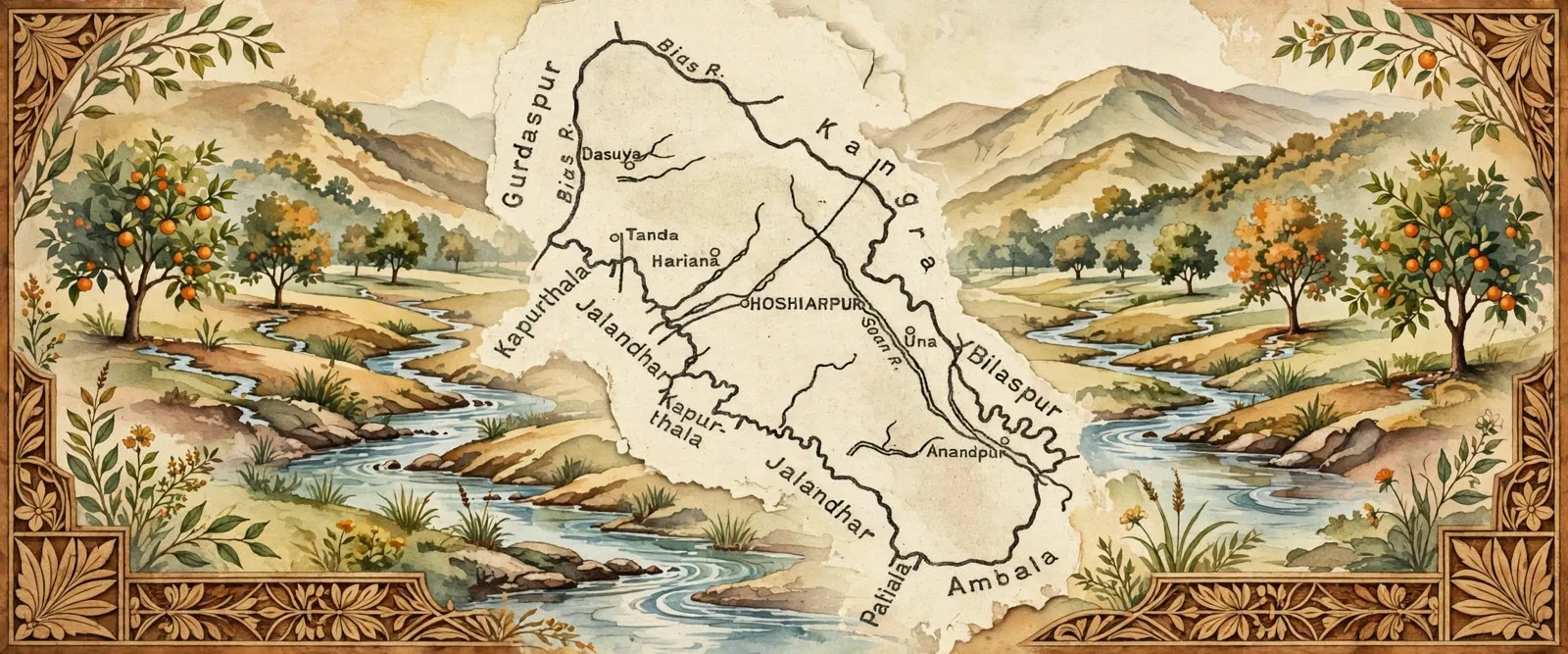
Hoshiarpur district is a district of Punjab in the Doaba region, lying between the Beas river and the Shivalik hills, with its headquarters at Hoshiarpur city. Census 2011 counted 1,586,625 people in 3,386 square kilometres, with literacy of 84.6 percent. It is known for the ancient temple site of Dholbaha, its 300 year old wood inlay craft and its citrus orchards.
- Punjabi name
- ਹੁਸ਼ਿਆਰਪੁਰ
- District
- Hoshiarpur
- State
- Punjab
- Region
- Doaba (Bist Doab)
- Headquarters
- Hoshiarpur
- Area
- 3,386 sq km
All 16 facts
- Population (Census 2011)
- 1,586,625
- Literacy
- 84.6%
- Sex ratio
- 961 females per 1,000 males
- Tehsils
- 4 (Hoshiarpur, Dasuya, Garhshankar, Mukerian)
- Blocks
- 10
- Villages
- 1,419
- Language
- Punjabi
- Known for
- Wood inlay work, Dholbaha temples, citrus orchards
- Coordinates
- 31.53° N, 75.92° E (headquarters)
- Population
- 1,586,625 (2011)
Hoshiarpur district is a district in the Doaba region of Punjab, India, set between the Beas river and the Shivalik hills. It is known for ancient temple remains at Dholbaha, a centuries old wood inlay craft, citrus orchards in its Kandi belt and a strong tradition of migration that links its villages to the Punjabi diaspora.
Where is Hoshiarpur district?
Hoshiarpur district is in the north east of Punjab, in the Bist Doab tract of the Doaba region, the land that lies between the Beas and the Sutlej rivers. It falls in the Jalandhar revenue division. To the north east it borders the Kangra and Una districts of Himachal Pradesh, to the south west it meets Jalandhar and Kapurthala, and to the north west it meets Gurdaspur. The headquarters is the city of Hoshiarpur, which sits at 31.53 degrees north and 75.92 degrees east, a short distance from the Shivalik foothills. Administratively, Census 2011 counted four subdivisions, ten development blocks, ten towns and 1,419 villages in the district, of which 1,388 were inhabited. Its main towns include Hoshiarpur, Dasuya, Mukerian, Garhshankar and Tanda, each serving the villages and orchards around it.
History
People have lived in this hill foot country for a very long time. Archaeological exploration in the Shivalik foothills has found early Stone Age tools at Atbarapur, Rehmanpur and Takhni, and surface exploration has traced the district back to the Harappan period, the age of the Indus Valley Civilisation. Its best known ancient site is Dholbaha, north of Hoshiarpur city, where fossils, stone tools and fine sandstone sculptures have been found. The sculptures belong to the Gurjara Pratihara period, roughly 800 to 1100 AD, and point to a valley of temples and skilled stone carvers. Local tradition links Dasuya with the Mahabharata, as the seat of King Virata, where the Pandavas are said to have spent part of their exile.
In the medieval centuries the plains and the hills often had different rulers. The district administration history records that the plains probably came under Muslim rule after the fall of Jalandhar in 1088, while the hill chiefs held on in the Shivaliks. The country later formed part of the old Katoch kingdom of Jalandhar and was divided between the rajas of Datarpur and Jaswan, before Maharaja Ranjit Singh brought the tract between the Sutlej and the Beas under Lahore by 1818. After the First Anglo Sikh War, the district was annexed by the British in 1846, along with the rest of the Jalandhar Doab. Its map kept changing afterwards: Una went to Himachal Pradesh after state reorganisation, and Balachaur tehsil was transferred to the newly created Nawanshahr district, leaving the four subdivision district of today.
Geography and people
The district covers 3,386 square kilometres and divides into two roughly equal parts: hill country in the east and plain country in the west. The eastern side is the Kandi belt, a sub mountainous strip along the Shivaliks cut by choes, the seasonal torrents that rush down from the hills in the monsoon. The district site counts 39 such rivulets, and check dams built on them in recent decades have added ponds and greenery to a tract that was once dry and eroded. The Beas runs along the north west, with fertile lowland along its banks where rice is grown, while the Sutlej touches the southern edge. Average rainfall is 1,125 mm, and the hills and forest cover give the district a milder climate than most of Punjab.
Census 2011 counted 1,586,625 people, at a density of 469 people per square kilometre. About 78.9 percent lived in villages and 21.1 percent in towns. Literacy was 84.6 percent, with male literacy at 88.8 percent and female literacy at 80.3 percent, among the strongest figures in Punjab. The sex ratio was 961 females per 1,000 males, well above the state average. Hindus formed 63.07 percent of the population and Sikhs 33.92 percent, with small Muslim and Christian communities. Punjabi is the official and everyday language. Like the rest of Doaba, the district has a deep culture of migration: generations of its sons and daughters have settled in Canada, Britain, the United States and beyond, and their remittances, houses and family ties shape village life to this day.
Places of interest
Start at Dholbaha, where the remains of early medieval temples and their sculptures sit in a green valley below the Shivaliks, and where the Archaeological Museum displays fossils and Pleistocene era finds from the area. In Hoshiarpur city, the Sheesh Mahal, built in 1911 by Lala Hans Raj Jain, is covered inside and out with glass work and carries sculptures linked to the coronation of King George V. A short drive south east stands Bajwara Fort, a ruined fortress spread over six to seven acres, captured by Maharaja Ranjit Singh in 1825 and later used by the British as a prison after the 1857 revolt. Its two surviving bastions are fragile, so admire it from outside.
Faith sites draw visitors all year. The Kamahi Devi temple, dedicated to the goddess Kamakshi, is linked by tradition to the Pandavas. Gurdwara Garna Sahib at Bodal, in Dasuya tehsil, remembers Guru Hargobind Ji, and Gurdwara Harian Velan remembers Guru Har Rai Ji. The tomb of Shah Noor Jamal in Hoshiarpur city hosts an annual Urs in March that draws devotees of every community. For nature, the Takhni Rehmapur Wildlife Sanctuary protects dry deciduous forest in the Shivalik foothills, home to deer, wild boar, hare and rich birdlife, best explored on foot in the cooler months.
Economy and crafts
Farming is the backbone of the district. The Beas side flats grow rice, the plains grow wheat, maize and sugarcane, and the Kandi belt has turned increasingly to fruit. Hoshiarpur city is fondly called a city of mangoes, and citrus is the rising crop: the Citrus Estate at Bhunga, set up by the Punjab Department of Horticulture in 2007, trains and supports over 6,000 farmers across nearly 380 villages on about 1,900 hectares, promoting kinnow, sweet orange and tangerine as an alternative to thirsty paddy.
The craft the district is famous for is wood inlay. About 300 years ago Hoshiarpur was a centre of ivory bangle and comb making, and artisans began setting the discarded ivory offcuts into dark sheesham wood. Since ivory was banned, the inlayers have worked in acrylic, plastic, bronze and camel bone, cutting floral and geometric patterns into sheesham, teak and rosewood to make tables, screens, boxes and trays. Pieces from Hoshiarpur are still gifted to visiting dignitaries, and its workshops remain the best place in Punjab to watch the craft at close quarters. Education, small industry and remittance income from the diaspora round out the modern economy.
Getting there and today
Hoshiarpur is well connected. Its own railway station, code HSX and dating to 1905, links the city through Jalandhar to Delhi, Amritsar and Ferozepur, and the Bhagwan Valmiki Interstate Bus Terminal runs buses across Punjab and to Himachal Pradesh, Delhi and Chandigarh. The nearest airport is Adampur, about 25 km south west, and the international airport at Amritsar is about 125 km away. Roads climb from the city into the hills toward Una and Kangra, which is why travellers often call Hoshiarpur a gateway to Himachal.
Today the district balances three identities at once: a quiet administrative and education centre, a farming and orchard economy adapting to less water, and a homeland district for a worldwide diaspora that returns every winter. The best time to visit is November to February, when the choes are dry, the citrus is ripening and the Shivalik light is at its clearest.
ਹੁਸ਼ਿਆਰਪੁਰ ਜ਼ਿਲ੍ਹਾ ਭਾਰਤ ਦੇ ਪੰਜਾਬ ਸੂਬੇ ਦੇ ਦੋਆਬਾ ਖੇਤਰ ਦਾ ਇੱਕ ਜ਼ਿਲ੍ਹਾ ਹੈ, ਜੋ ਬਿਆਸ ਦਰਿਆ ਅਤੇ ਸ਼ਿਵਾਲਿਕ ਪਹਾੜੀਆਂ ਦੇ ਵਿਚਕਾਰ ਵਸਿਆ ਹੋਇਆ ਹੈ। ਇਹ ਢੋਲਬਾਹਾ ਦੇ ਪੁਰਾਤਨ ਮੰਦਰ ਖੰਡਰਾਂ, ਸਦੀਆਂ ਪੁਰਾਣੀ ਲੱਕੜ ਜੜ੍ਹਾਈ ਦੀ ਕਲਾ, ਕੰਡੀ ਖੇਤਰ ਦੇ ਸੰਤਰਾ ਬਾਗਾਂ ਅਤੇ ਪਰਵਾਸ ਦੀ ਉਸ ਮਜ਼ਬੂਤ ਪਰੰਪਰਾ ਲਈ ਜਾਣਿਆ ਜਾਂਦਾ ਹੈ ਜੋ ਇਸ ਦੇ ਪਿੰਡਾਂ ਨੂੰ ਸੰਸਾਰ ਭਰ ਦੇ ਪੰਜਾਬੀ ਪਰਵਾਸੀਆਂ ਨਾਲ ਜੋੜਦੀ ਹੈ।
ਹੁਸ਼ਿਆਰਪੁਰ ਜ਼ਿਲ੍ਹਾ ਕਿੱਥੇ ਹੈ?
ਹੁਸ਼ਿਆਰਪੁਰ ਜ਼ਿਲ੍ਹਾ ਪੰਜਾਬ ਦੇ ਉੱਤਰ ਪੂਰਬ ਵਿੱਚ ਹੈ, ਦੋਆਬਾ ਖੇਤਰ ਦੇ ਬਿਸਤ ਦੋਆਬ ਇਲਾਕੇ ਵਿੱਚ, ਜੋ ਬਿਆਸ ਅਤੇ ਸਤਲੁਜ ਦਰਿਆਵਾਂ ਦੇ ਵਿਚਕਾਰਲੀ ਧਰਤੀ ਹੈ। ਇਹ ਜਲੰਧਰ ਮਾਲ ਡਵੀਜ਼ਨ ਵਿੱਚ ਆਉਂਦਾ ਹੈ। ਇਸ ਦੇ ਉੱਤਰ ਪੂਰਬ ਵਿੱਚ ਹਿਮਾਚਲ ਪ੍ਰਦੇਸ਼ ਦੇ ਕਾਂਗੜਾ ਅਤੇ ਊਨਾ ਜ਼ਿਲ੍ਹੇ ਹਨ, ਦੱਖਣ ਪੱਛਮ ਵਿੱਚ ਜਲੰਧਰ ਅਤੇ ਕਪੂਰਥਲਾ ਹਨ, ਅਤੇ ਉੱਤਰ ਪੱਛਮ ਵਿੱਚ ਗੁਰਦਾਸਪੁਰ ਹੈ। ਜ਼ਿਲ੍ਹੇ ਦਾ ਸਦਰ ਮੁਕਾਮ ਹੁਸ਼ਿਆਰਪੁਰ ਸ਼ਹਿਰ ਹੈ, ਜੋ 31.53 ਡਿਗਰੀ ਉੱਤਰ ਅਤੇ 75.92 ਡਿਗਰੀ ਪੂਰਬ ਉੱਤੇ, ਸ਼ਿਵਾਲਿਕ ਦੀਆਂ ਤਲਹਟੀਆਂ ਦੇ ਨੇੜੇ ਸਥਿਤ ਹੈ। ਜਨਗਣਨਾ 2011 ਅਨੁਸਾਰ ਜ਼ਿਲ੍ਹੇ ਵਿੱਚ ਚਾਰ ਸਬ ਡਵੀਜ਼ਨਾਂ, ਦਸ ਵਿਕਾਸ ਬਲਾਕ, ਦਸ ਕਸਬੇ ਅਤੇ 1,419 ਪਿੰਡ ਸਨ, ਜਿਨ੍ਹਾਂ ਵਿੱਚੋਂ 1,388 ਵਿੱਚ ਆਬਾਦੀ ਰਹਿੰਦੀ ਸੀ। ਇਸ ਦੇ ਮੁੱਖ ਕਸਬਿਆਂ ਵਿੱਚ ਹੁਸ਼ਿਆਰਪੁਰ, ਦਸੂਹਾ, ਮੁਕੇਰੀਆਂ, ਗੜ੍ਹਸ਼ੰਕਰ ਅਤੇ ਟਾਂਡਾ ਸ਼ਾਮਲ ਹਨ।
ਇਤਿਹਾਸ
ਇਸ ਪਹਾੜੀ ਤਲਹਟੀ ਇਲਾਕੇ ਵਿੱਚ ਮਨੁੱਖ ਬਹੁਤ ਪੁਰਾਣੇ ਸਮੇਂ ਤੋਂ ਵਸਦਾ ਆਇਆ ਹੈ। ਸ਼ਿਵਾਲਿਕ ਦੀਆਂ ਤਲਹਟੀਆਂ ਵਿੱਚ ਕੀਤੀ ਖੋਜ ਵਿੱਚ ਅਤਬਾਰਾਪੁਰ, ਰਹਿਮਾਨਪੁਰ ਅਤੇ ਤਖਣੀ ਤੋਂ ਮੁੱਢਲੇ ਪੱਥਰ ਯੁੱਗ ਦੇ ਸੰਦ ਮਿਲੇ ਹਨ, ਅਤੇ ਸਤਹੀ ਖੋਜ ਨੇ ਜ਼ਿਲ੍ਹੇ ਦਾ ਸੰਬੰਧ ਹੜੱਪਾ ਕਾਲ, ਭਾਵ ਸਿੰਧੂ ਘਾਟੀ ਸੱਭਿਅਤਾ ਦੇ ਸਮੇਂ ਨਾਲ ਜੋੜਿਆ ਹੈ। ਇਸ ਦਾ ਸਭ ਤੋਂ ਮਸ਼ਹੂਰ ਪੁਰਾਤਨ ਸਥਾਨ ਢੋਲਬਾਹਾ ਹੈ, ਜੋ ਹੁਸ਼ਿਆਰਪੁਰ ਸ਼ਹਿਰ ਦੇ ਉੱਤਰ ਵਿੱਚ ਹੈ। ਇੱਥੋਂ ਜੀਵਾਸ਼ਮ, ਪੱਥਰ ਦੇ ਸੰਦ ਅਤੇ ਸੋਹਣੀਆਂ ਰੇਤਲੇ ਪੱਥਰ ਦੀਆਂ ਮੂਰਤੀਆਂ ਮਿਲੀਆਂ ਹਨ। ਇਹ ਮੂਰਤੀਆਂ ਗੁਰਜਰ ਪ੍ਰਤੀਹਾਰ ਕਾਲ ਦੀਆਂ ਹਨ, ਲਗਭਗ 800 ਤੋਂ 1100 ਈਸਵੀ, ਅਤੇ ਇਹ ਇੱਕ ਅਜਿਹੀ ਘਾਟੀ ਵੱਲ ਇਸ਼ਾਰਾ ਕਰਦੀਆਂ ਹਨ ਜਿੱਥੇ ਮੰਦਰ ਅਤੇ ਕੁਸ਼ਲ ਪੱਥਰ ਘਾੜੇ ਸਨ। ਸਥਾਨਕ ਪਰੰਪਰਾ ਦਸੂਹਾ ਨੂੰ ਮਹਾਭਾਰਤ ਨਾਲ ਜੋੜਦੀ ਹੈ, ਰਾਜਾ ਵਿਰਾਟ ਦੇ ਰਾਜ ਵਜੋਂ, ਜਿੱਥੇ ਕਿਹਾ ਜਾਂਦਾ ਹੈ ਕਿ ਪਾਂਡਵਾਂ ਨੇ ਆਪਣੇ ਬਨਵਾਸ ਦਾ ਕੁਝ ਹਿੱਸਾ ਬਿਤਾਇਆ ਸੀ।
ਵਿਚਕਾਰਲੇ ਸਦੀਆਂ ਵਿੱਚ ਮੈਦਾਨ ਅਤੇ ਪਹਾੜਾਂ ਦੇ ਹਾਕਮ ਅਕਸਰ ਵੱਖ ਵੱਖ ਰਹੇ। ਜ਼ਿਲ੍ਹਾ ਪ੍ਰਸ਼ਾਸਨ ਦੇ ਇਤਿਹਾਸ ਅਨੁਸਾਰ 1088 ਵਿੱਚ ਜਲੰਧਰ ਦੇ ਪਤਨ ਤੋਂ ਬਾਅਦ ਮੈਦਾਨ ਸ਼ਾਇਦ ਮੁਸਲਮਾਨ ਹਕੂਮਤ ਹੇਠ ਆ ਗਏ, ਜਦਕਿ ਪਹਾੜੀ ਸਰਦਾਰ ਸ਼ਿਵਾਲਿਕ ਵਿੱਚ ਟਿਕੇ ਰਹੇ। ਇਹ ਇਲਾਕਾ ਬਾਅਦ ਵਿੱਚ ਜਲੰਧਰ ਦੇ ਪੁਰਾਣੇ ਕਟੋਚ ਰਾਜ ਦਾ ਹਿੱਸਾ ਰਿਹਾ ਅਤੇ ਦਾਤਾਰਪੁਰ ਅਤੇ ਜਸਵਾਂ ਦੇ ਰਾਜਿਆਂ ਵਿੱਚ ਵੰਡਿਆ ਗਿਆ, ਫਿਰ ਮਹਾਰਾਜਾ ਰਣਜੀਤ ਸਿੰਘ ਨੇ 1818 ਤੱਕ ਸਤਲੁਜ ਅਤੇ ਬਿਆਸ ਦੇ ਵਿਚਕਾਰਲਾ ਇਲਾਕਾ ਲਾਹੌਰ ਹੇਠ ਲੈ ਆਂਦਾ। ਪਹਿਲੀ ਐਂਗਲੋ ਸਿੱਖ ਜੰਗ ਤੋਂ ਬਾਅਦ 1846 ਵਿੱਚ ਇਹ ਜ਼ਿਲ੍ਹਾ ਬਾਕੀ ਜਲੰਧਰ ਦੋਆਬ ਸਮੇਤ ਅੰਗਰੇਜ਼ਾਂ ਦੇ ਕਬਜ਼ੇ ਵਿੱਚ ਚਲਾ ਗਿਆ। ਇਸ ਦਾ ਨਕਸ਼ਾ ਬਾਅਦ ਵਿੱਚ ਵੀ ਬਦਲਦਾ ਰਿਹਾ। ਊਨਾ ਸੂਬਿਆਂ ਦੀ ਮੁੜ ਵੰਡ ਤੋਂ ਬਾਅਦ ਹਿਮਾਚਲ ਪ੍ਰਦੇਸ਼ ਵਿੱਚ ਚਲਾ ਗਿਆ ਅਤੇ ਬਾਲਾਚੌਰ ਤਹਿਸੀਲ ਨਵੇਂ ਬਣੇ ਨਵਾਂਸ਼ਹਿਰ ਜ਼ਿਲ੍ਹੇ ਵਿੱਚ ਚਲੀ ਗਈ, ਜਿਸ ਨਾਲ ਅੱਜ ਦਾ ਚਾਰ ਸਬ ਡਵੀਜ਼ਨਾਂ ਵਾਲਾ ਜ਼ਿਲ੍ਹਾ ਰਹਿ ਗਿਆ।
ਭੂਗੋਲ ਅਤੇ ਲੋਕ
ਇਹ ਜ਼ਿਲ੍ਹਾ 3,386 ਵਰਗ ਕਿਲੋਮੀਟਰ ਵਿੱਚ ਫੈਲਿਆ ਹੈ ਅਤੇ ਲਗਭਗ ਦੋ ਬਰਾਬਰ ਹਿੱਸਿਆਂ ਵਿੱਚ ਵੰਡਿਆ ਹੈ, ਪੂਰਬ ਵਿੱਚ ਪਹਾੜੀ ਇਲਾਕਾ ਅਤੇ ਪੱਛਮ ਵਿੱਚ ਮੈਦਾਨੀ ਇਲਾਕਾ। ਪੂਰਬੀ ਹਿੱਸਾ ਕੰਡੀ ਪੱਟੀ ਹੈ, ਸ਼ਿਵਾਲਿਕ ਨਾਲ ਲੱਗਦੀ ਅਰਧ ਪਹਾੜੀ ਧਰਤੀ, ਜਿਸ ਨੂੰ ਚੋਅ ਕੱਟਦੇ ਹਨ। ਚੋਅ ਉਹ ਮੌਸਮੀ ਨਾਲੇ ਹਨ ਜੋ ਬਰਸਾਤ ਵਿੱਚ ਪਹਾੜਾਂ ਤੋਂ ਤੇਜ਼ੀ ਨਾਲ ਉਤਰਦੇ ਹਨ। ਜ਼ਿਲ੍ਹੇ ਦੀ ਸਾਈਟ ਅਜਿਹੇ 39 ਨਾਲੇ ਗਿਣਦੀ ਹੈ, ਅਤੇ ਹਾਲ ਦੇ ਦਹਾਕਿਆਂ ਵਿੱਚ ਇਨ੍ਹਾਂ ਉੱਤੇ ਬਣੇ ਚੈੱਕ ਡੈਮਾਂ ਨੇ ਉਸ ਇਲਾਕੇ ਵਿੱਚ ਤਲਾਬ ਅਤੇ ਹਰਿਆਲੀ ਵਧਾਈ ਹੈ ਜੋ ਕਦੇ ਖੁਸ਼ਕ ਅਤੇ ਖੋਰਾ ਲੱਗਾ ਸੀ। ਬਿਆਸ ਉੱਤਰ ਪੱਛਮ ਦੇ ਨਾਲ ਨਾਲ ਵਗਦਾ ਹੈ, ਜਿਸ ਦੇ ਕੰਢਿਆਂ ਦੀ ਉਪਜਾਊ ਨੀਵੀਂ ਧਰਤੀ ਵਿੱਚ ਝੋਨਾ ਉਗਾਇਆ ਜਾਂਦਾ ਹੈ, ਜਦਕਿ ਸਤਲੁਜ ਦੱਖਣੀ ਕਿਨਾਰੇ ਨੂੰ ਛੂਹਦਾ ਹੈ। ਔਸਤ ਬਾਰਸ਼ 1,125 ਮਿਲੀਮੀਟਰ ਹੈ, ਅਤੇ ਪਹਾੜਾਂ ਤੇ ਜੰਗਲਾਂ ਕਾਰਨ ਇੱਥੇ ਦਾ ਮੌਸਮ ਪੰਜਾਬ ਦੇ ਬਹੁਤੇ ਹਿੱਸਿਆਂ ਨਾਲੋਂ ਨਰਮ ਹੈ।
ਜਨਗਣਨਾ 2011 ਵਿੱਚ ਆਬਾਦੀ 1,586,625 ਗਿਣੀ ਗਈ, ਅਤੇ ਘਣਤਾ 469 ਲੋਕ ਪ੍ਰਤੀ ਵਰਗ ਕਿਲੋਮੀਟਰ ਸੀ। ਲਗਭਗ 78.9 ਫੀਸਦੀ ਲੋਕ ਪਿੰਡਾਂ ਵਿੱਚ ਅਤੇ 21.1 ਫੀਸਦੀ ਕਸਬਿਆਂ ਵਿੱਚ ਰਹਿੰਦੇ ਸਨ। ਸਾਖਰਤਾ 84.6 ਫੀਸਦੀ ਸੀ, ਜਿਸ ਵਿੱਚ ਮਰਦ ਸਾਖਰਤਾ 88.8 ਫੀਸਦੀ ਅਤੇ ਔਰਤ ਸਾਖਰਤਾ 80.3 ਫੀਸਦੀ ਸੀ, ਜੋ ਪੰਜਾਬ ਦੇ ਸਭ ਤੋਂ ਵਧੀਆ ਅੰਕੜਿਆਂ ਵਿੱਚੋਂ ਹੈ। ਲਿੰਗ ਅਨੁਪਾਤ ਹਰ 1,000 ਮਰਦਾਂ ਪਿੱਛੇ 961 ਔਰਤਾਂ ਸੀ, ਜੋ ਸੂਬੇ ਦੀ ਔਸਤ ਤੋਂ ਕਾਫੀ ਉੱਪਰ ਹੈ। ਆਬਾਦੀ ਵਿੱਚ ਹਿੰਦੂ 63.07 ਫੀਸਦੀ ਅਤੇ ਸਿੱਖ 33.92 ਫੀਸਦੀ ਸਨ, ਅਤੇ ਛੋਟੀਆਂ ਮੁਸਲਮਾਨ ਅਤੇ ਈਸਾਈ ਭਾਈਚਾਰਕ ਇਕਾਈਆਂ ਵੀ ਹਨ। ਪੰਜਾਬੀ ਸਰਕਾਰੀ ਅਤੇ ਰੋਜ਼ਾਨਾ ਦੀ ਭਾਸ਼ਾ ਹੈ। ਬਾਕੀ ਦੋਆਬਾ ਵਾਂਗ ਇੱਥੇ ਪਰਵਾਸ ਦੀ ਡੂੰਘੀ ਪਰੰਪਰਾ ਹੈ। ਪੀੜ੍ਹੀਆਂ ਤੋਂ ਇਸ ਦੇ ਪੁੱਤਰ ਧੀਆਂ ਕੈਨੇਡਾ, ਬਰਤਾਨੀਆ, ਅਮਰੀਕਾ ਅਤੇ ਹੋਰ ਦੇਸ਼ਾਂ ਵਿੱਚ ਵਸੇ ਹੋਏ ਹਨ, ਅਤੇ ਉਨ੍ਹਾਂ ਦੀ ਕਮਾਈ, ਘਰ ਅਤੇ ਪਰਿਵਾਰਕ ਸਾਂਝ ਅੱਜ ਵੀ ਪਿੰਡਾਂ ਦੀ ਜ਼ਿੰਦਗੀ ਨੂੰ ਰੂਪ ਦਿੰਦੇ ਹਨ।
ਵੇਖਣ ਯੋਗ ਥਾਵਾਂ
ਸ਼ੁਰੂਆਤ ਢੋਲਬਾਹਾ ਤੋਂ ਕਰੋ, ਜਿੱਥੇ ਮੁੱਢਲੇ ਵਿਚਕਾਰਲੇ ਕਾਲ ਦੇ ਮੰਦਰਾਂ ਦੇ ਖੰਡਰ ਅਤੇ ਮੂਰਤੀਆਂ ਸ਼ਿਵਾਲਿਕ ਹੇਠ ਹਰੀ ਘਾਟੀ ਵਿੱਚ ਹਨ, ਅਤੇ ਜਿੱਥੇ ਪੁਰਾਤੱਤਵ ਅਜਾਇਬ ਘਰ ਵਿੱਚ ਇਲਾਕੇ ਤੋਂ ਮਿਲੇ ਜੀਵਾਸ਼ਮ ਅਤੇ ਪੁਰਾਣੇ ਪੱਥਰ ਯੁੱਗ ਦੀਆਂ ਵਸਤਾਂ ਰੱਖੀਆਂ ਹਨ। ਹੁਸ਼ਿਆਰਪੁਰ ਸ਼ਹਿਰ ਵਿੱਚ ਸ਼ੀਸ਼ ਮਹਿਲ ਹੈ, ਜੋ 1911 ਵਿੱਚ ਲਾਲਾ ਹੰਸ ਰਾਜ ਜੈਨ ਨੇ ਬਣਵਾਇਆ ਸੀ। ਇਹ ਅੰਦਰੋਂ ਅਤੇ ਬਾਹਰੋਂ ਸ਼ੀਸ਼ੇ ਦੇ ਕੰਮ ਨਾਲ ਢਕਿਆ ਹੈ ਅਤੇ ਇਸ ਉੱਤੇ ਰਾਜਾ ਜਾਰਜ ਪੰਜਵੇਂ ਦੀ ਤਾਜਪੋਸ਼ੀ ਨਾਲ ਜੁੜੀਆਂ ਮੂਰਤੀਆਂ ਹਨ। ਥੋੜ੍ਹੀ ਦੂਰ ਦੱਖਣ ਪੂਰਬ ਵਿੱਚ ਬਜਵਾੜਾ ਕਿਲ੍ਹਾ ਹੈ, ਛੇ ਤੋਂ ਸੱਤ ਏਕੜ ਵਿੱਚ ਫੈਲਿਆ ਇੱਕ ਖੰਡਰ ਕਿਲ੍ਹਾ, ਜਿਸ ਨੂੰ ਮਹਾਰਾਜਾ ਰਣਜੀਤ ਸਿੰਘ ਨੇ 1825 ਵਿੱਚ ਜਿੱਤਿਆ ਸੀ ਅਤੇ ਜਿਸ ਨੂੰ ਬਾਅਦ ਵਿੱਚ ਅੰਗਰੇਜ਼ਾਂ ਨੇ 1857 ਦੇ ਵਿਦਰੋਹ ਤੋਂ ਬਾਅਦ ਕੈਦਖਾਨੇ ਵਜੋਂ ਵਰਤਿਆ। ਇਸ ਦੇ ਬਚੇ ਦੋ ਬੁਰਜ ਕਮਜ਼ੋਰ ਹਾਲਤ ਵਿੱਚ ਹਨ, ਇਸ ਲਈ ਇਸ ਨੂੰ ਬਾਹਰੋਂ ਹੀ ਵੇਖੋ।
ਧਾਰਮਿਕ ਥਾਵਾਂ ਸਾਰਾ ਸਾਲ ਸ਼ਰਧਾਲੂਆਂ ਨੂੰ ਖਿੱਚਦੀਆਂ ਹਨ। ਕਮਾਹੀ ਦੇਵੀ ਮੰਦਰ ਦੇਵੀ ਕਾਮਾਖਿਆ ਨੂੰ ਸਮਰਪਿਤ ਹੈ ਅਤੇ ਪਰੰਪਰਾ ਇਸ ਨੂੰ ਪਾਂਡਵਾਂ ਨਾਲ ਜੋੜਦੀ ਹੈ। ਦਸੂਹਾ ਤਹਿਸੀਲ ਦੇ ਬੋਦਲ ਪਿੰਡ ਵਿੱਚ ਗੁਰਦੁਆਰਾ ਗਰਨਾ ਸਾਹਿਬ ਗੁਰੂ ਹਰਿਗੋਬਿੰਦ ਜੀ ਦੀ ਯਾਦ ਨਾਲ ਜੁੜਿਆ ਹੈ, ਅਤੇ ਗੁਰਦੁਆਰਾ ਹਰੀਆਂ ਵੇਲਾਂ ਗੁਰੂ ਹਰਿ ਰਾਇ ਜੀ ਦੀ ਯਾਦ ਦਿਵਾਉਂਦਾ ਹੈ। ਹੁਸ਼ਿਆਰਪੁਰ ਸ਼ਹਿਰ ਵਿੱਚ ਸ਼ਾਹ ਨੂਰ ਜਮਾਲ ਦੀ ਦਰਗਾਹ ਉੱਤੇ ਮਾਰਚ ਵਿੱਚ ਸਾਲਾਨਾ ਉਰਸ ਲੱਗਦਾ ਹੈ, ਜਿੱਥੇ ਹਰ ਭਾਈਚਾਰੇ ਦੇ ਲੋਕ ਆਉਂਦੇ ਹਨ। ਕੁਦਰਤ ਲਈ ਤਖਣੀ ਰਹਿਮਾਪੁਰ ਜੰਗਲੀ ਜੀਵ ਅਭਿਆਰਣ ਸ਼ਿਵਾਲਿਕ ਦੀਆਂ ਤਲਹਟੀਆਂ ਦੇ ਖੁਸ਼ਕ ਪਤਝੜੀ ਜੰਗਲ ਦੀ ਰਾਖੀ ਕਰਦਾ ਹੈ, ਜਿੱਥੇ ਹਿਰਨ, ਜੰਗਲੀ ਸੂਰ, ਸਹੇ ਅਤੇ ਕਈ ਤਰ੍ਹਾਂ ਦੇ ਪੰਛੀ ਮਿਲਦੇ ਹਨ। ਠੰਢੇ ਮਹੀਨਿਆਂ ਵਿੱਚ ਇੱਥੇ ਪੈਦਲ ਘੁੰਮਣਾ ਸਭ ਤੋਂ ਵਧੀਆ ਰਹਿੰਦਾ ਹੈ।
ਆਰਥਿਕਤਾ ਅਤੇ ਦਸਤਕਾਰੀ
ਖੇਤੀ ਜ਼ਿਲ੍ਹੇ ਦੀ ਰੀੜ੍ਹ ਦੀ ਹੱਡੀ ਹੈ। ਬਿਆਸ ਵੱਲ ਦੀਆਂ ਨੀਵੀਆਂ ਜ਼ਮੀਨਾਂ ਵਿੱਚ ਝੋਨਾ ਹੁੰਦਾ ਹੈ, ਮੈਦਾਨਾਂ ਵਿੱਚ ਕਣਕ, ਮੱਕੀ ਅਤੇ ਗੰਨਾ ਹੁੰਦਾ ਹੈ, ਅਤੇ ਕੰਡੀ ਪੱਟੀ ਫਲਾਂ ਵੱਲ ਵਧ ਰਹੀ ਹੈ। ਹੁਸ਼ਿਆਰਪੁਰ ਸ਼ਹਿਰ ਨੂੰ ਅੰਬਾਂ ਦਾ ਸ਼ਹਿਰ ਕਿਹਾ ਜਾਂਦਾ ਹੈ, ਅਤੇ ਖੱਟੇ ਫਲ ਉੱਭਰਦੀ ਫਸਲ ਹਨ। ਭੂੰਗਾ ਵਿਖੇ ਸਿਟਰਸ ਅਸਟੇਟ, ਜੋ ਪੰਜਾਬ ਦੇ ਬਾਗਬਾਨੀ ਵਿਭਾਗ ਨੇ 2007 ਵਿੱਚ ਬਣਾਈ ਸੀ, ਲਗਭਗ 380 ਪਿੰਡਾਂ ਦੇ 6,000 ਤੋਂ ਵੱਧ ਕਿਸਾਨਾਂ ਨੂੰ ਲਗਭਗ 1,900 ਹੈਕਟੇਅਰ ਉੱਤੇ ਸਹਾਇਤਾ ਦਿੰਦੀ ਹੈ, ਅਤੇ ਜ਼ਿਆਦਾ ਪਾਣੀ ਵਾਲੇ ਝੋਨੇ ਦੇ ਬਦਲ ਵਜੋਂ ਕਿੰਨੂ, ਮਾਲਟਾ ਅਤੇ ਨਾਰੰਗੀ ਨੂੰ ਉਤਸ਼ਾਹਿਤ ਕਰਦੀ ਹੈ।
ਜਿਸ ਦਸਤਕਾਰੀ ਲਈ ਇਹ ਜ਼ਿਲ੍ਹਾ ਮਸ਼ਹੂਰ ਹੈ, ਉਹ ਲੱਕੜ ਜੜ੍ਹਾਈ ਹੈ। ਲਗਭਗ 300 ਸਾਲ ਪਹਿਲਾਂ ਹੁਸ਼ਿਆਰਪੁਰ ਹਾਥੀ ਦੰਦ ਦੀਆਂ ਚੂੜੀਆਂ ਅਤੇ ਕੰਘੀਆਂ ਦਾ ਕੇਂਦਰ ਸੀ, ਅਤੇ ਕਾਰੀਗਰਾਂ ਨੇ ਬਚੇ ਹੋਏ ਹਾਥੀ ਦੰਦ ਦੇ ਟੁਕੜੇ ਗੂੜ੍ਹੀ ਸ਼ੀਸ਼ਮ ਦੀ ਲੱਕੜ ਵਿੱਚ ਜੜਨੇ ਸ਼ੁਰੂ ਕਰ ਦਿੱਤੇ। ਹਾਥੀ ਦੰਦ ਉੱਤੇ ਪਾਬੰਦੀ ਤੋਂ ਬਾਅਦ ਜੜ੍ਹਾਈ ਵਾਲੇ ਕਾਰੀਗਰ ਐਕਰੀਲਿਕ, ਪਲਾਸਟਿਕ, ਕਾਂਸੀ ਅਤੇ ਊਠ ਦੀ ਹੱਡੀ ਨਾਲ ਕੰਮ ਕਰਦੇ ਹਨ, ਅਤੇ ਸ਼ੀਸ਼ਮ, ਟੀਕ ਅਤੇ ਰੋਜ਼ਵੁੱਡ ਵਿੱਚ ਫੁੱਲ ਪੱਤੀ ਅਤੇ ਰੇਖਾਵੀ ਨਕਸ਼ੇ ਕੱਟ ਕੇ ਮੇਜ਼, ਪਰਦੇ, ਡੱਬੇ ਅਤੇ ਟਰੇਆਂ ਬਣਾਉਂਦੇ ਹਨ। ਹੁਸ਼ਿਆਰਪੁਰ ਦੀਆਂ ਬਣੀਆਂ ਚੀਜ਼ਾਂ ਅੱਜ ਵੀ ਮਹਿਮਾਨ ਆਗੂਆਂ ਨੂੰ ਤੋਹਫੇ ਵਜੋਂ ਦਿੱਤੀਆਂ ਜਾਂਦੀਆਂ ਹਨ, ਅਤੇ ਇਸ ਦੀਆਂ ਵਰਕਸ਼ਾਪਾਂ ਇਸ ਕਲਾ ਨੂੰ ਨੇੜਿਓਂ ਵੇਖਣ ਲਈ ਪੰਜਾਬ ਦੀ ਸਭ ਤੋਂ ਵਧੀਆ ਥਾਂ ਹਨ। ਸਿੱਖਿਆ, ਛੋਟੇ ਉਦਯੋਗ ਅਤੇ ਪਰਵਾਸੀਆਂ ਵੱਲੋਂ ਭੇਜੀ ਕਮਾਈ ਅੱਜ ਦੀ ਆਰਥਿਕਤਾ ਦੇ ਬਾਕੀ ਥੰਮ੍ਹ ਹਨ।
ਇੱਥੇ ਪਹੁੰਚਣਾ ਅਤੇ ਅੱਜ ਦਾ ਜ਼ਿਲ੍ਹਾ
ਹੁਸ਼ਿਆਰਪੁਰ ਚੰਗੀ ਤਰ੍ਹਾਂ ਜੁੜਿਆ ਹੋਇਆ ਹੈ। ਇਸ ਦਾ ਆਪਣਾ ਰੇਲਵੇ ਸਟੇਸ਼ਨ, ਜਿਸ ਦਾ ਕੋਡ HSX ਹੈ ਅਤੇ ਜੋ 1905 ਵਿੱਚ ਬਣਿਆ ਸੀ, ਸ਼ਹਿਰ ਨੂੰ ਜਲੰਧਰ ਰਾਹੀਂ ਦਿੱਲੀ, ਅੰਮ੍ਰਿਤਸਰ ਅਤੇ ਫਿਰੋਜ਼ਪੁਰ ਨਾਲ ਜੋੜਦਾ ਹੈ, ਅਤੇ ਭਗਵਾਨ ਵਾਲਮੀਕਿ ਅੰਤਰਰਾਜੀ ਬੱਸ ਅੱਡੇ ਤੋਂ ਪੰਜਾਬ ਭਰ ਅਤੇ ਹਿਮਾਚਲ ਪ੍ਰਦੇਸ਼, ਦਿੱਲੀ ਅਤੇ ਚੰਡੀਗੜ੍ਹ ਲਈ ਬੱਸਾਂ ਚੱਲਦੀਆਂ ਹਨ। ਸਭ ਤੋਂ ਨੇੜਲਾ ਹਵਾਈ ਅੱਡਾ ਆਦਮਪੁਰ ਹੈ, ਲਗਭਗ 25 ਕਿਲੋਮੀਟਰ ਦੱਖਣ ਪੱਛਮ ਵਿੱਚ, ਅਤੇ ਅੰਮ੍ਰਿਤਸਰ ਦਾ ਅੰਤਰਰਾਸ਼ਟਰੀ ਹਵਾਈ ਅੱਡਾ ਲਗਭਗ 125 ਕਿਲੋਮੀਟਰ ਦੂਰ ਹੈ। ਸ਼ਹਿਰ ਤੋਂ ਸੜਕਾਂ ਪਹਾੜਾਂ ਵੱਲ ਊਨਾ ਅਤੇ ਕਾਂਗੜਾ ਵੱਲ ਚੜ੍ਹਦੀਆਂ ਹਨ, ਇਸੇ ਲਈ ਯਾਤਰੀ ਹੁਸ਼ਿਆਰਪੁਰ ਨੂੰ ਹਿਮਾਚਲ ਦਾ ਦਰਵਾਜ਼ਾ ਕਹਿੰਦੇ ਹਨ।
ਅੱਜ ਇਹ ਜ਼ਿਲ੍ਹਾ ਇੱਕੋ ਸਮੇਂ ਤਿੰਨ ਪਛਾਣਾਂ ਸਾਂਭਦਾ ਹੈ, ਇੱਕ ਸ਼ਾਂਤ ਪ੍ਰਸ਼ਾਸਨਿਕ ਅਤੇ ਸਿੱਖਿਆ ਕੇਂਦਰ, ਘੱਟ ਪਾਣੀ ਨਾਲ ਤਾਲਮੇਲ ਬਿਠਾਉਂਦੀ ਖੇਤੀ ਅਤੇ ਬਾਗਾਂ ਦੀ ਆਰਥਿਕਤਾ, ਅਤੇ ਸੰਸਾਰ ਭਰ ਵਿੱਚ ਫੈਲੇ ਪਰਵਾਸੀਆਂ ਦਾ ਵਤਨ, ਜੋ ਹਰ ਸਰਦੀਆਂ ਵਿੱਚ ਵਾਪਸ ਆਉਂਦੇ ਹਨ। ਆਉਣ ਦਾ ਸਭ ਤੋਂ ਵਧੀਆ ਸਮਾਂ ਨਵੰਬਰ ਤੋਂ ਫਰਵਰੀ ਹੈ, ਜਦੋਂ ਚੋਅ ਖੁਸ਼ਕ ਹੁੰਦੇ ਹਨ, ਖੱਟੇ ਫਲ ਪੱਕ ਰਹੇ ਹੁੰਦੇ ਹਨ ਅਤੇ ਸ਼ਿਵਾਲਿਕ ਦੀ ਰੌਸ਼ਨੀ ਸਭ ਤੋਂ ਸਾਫ ਹੁੰਦੀ ਹੈ।
Nearby


All places in Hoshiarpur district
1,392 places in 4 tehsils · 1,385 villages
Tehsils of Hoshiarpur
- Abdullapurਅਬਡੁੱਲਾਪੁਰ
- Abdullapurਅਬਡੁੱਲਾਪੁਰ
- Abhowalਅਭੋਵਾਲ
- Abhowalਅਭੋਵਾਲ
- Achalpurਅਚਲਪੁਰ
- Achharwalਅਛਰਵਾਲ
- Adampur Mahotianਅਡਮਪੁਰ ਮਹੋਟਿਆਂ
- Adamwalਅਡਮਵਾਲ
- Adamwal Gariਅਡਮਵਾਲ ਗਰੀ
- Adhkaraਅਧਕਰਾ
- Ado Chakਅਡੋ ਚੱਕ
- Aglaurਅਗਲੌਰ
- Aharਅਹਰ
- Ahranaਅਹਰਨਾ
- Aimaਐਮਾ
- Aima Jattanਐਮਾ ਜੱਟਨ
- Aima Mangatਐਮਾ ਮਂਗਟ
- Aima Muglanਐਮਾ ਮੁਗਲਨ
- Ajjowalਅੱਜੋਵਾਲ
- Ajmerਅਜਮੇਰ
- Ajmerਅਜਮੇਰ
- Ajnohaਅਜਨੋਹਾ
- Ajramਅਜਰਮ
- Akalgarhਅਕਲਗੜ੍ਹ
- Akamਅਕਮ
- Akhlaspurਅਖਲਸਪੁਰ
- Aki Tundaਅਕੀ ਤੁਂਡਾ
- Alampurਆਲਮਪੁਰ
- Alamwalਆਲਮਵਾਲ
- Alar Pindਅਲਰ ਪਿੰਡ
- Alawal Isaਅਲਾਵਾਲ ਇਸਾ
- Alawalpurਅਲਾਵਾਲਪੁਰ
- Aleraਅਲੇਰਾ
- Alipurਅਲੀਪੁਰ
- Alipurਅਲੀਪੁਰ
- Alo Bhattiਅਲੋ ਭੱਟੀ
- Alowalਅਲੋਵਾਲ
- Ambala (Jattan)ਅਂਬਲਾ ਜੱਟਨ
- Ambuwaraਅਂਬੁਵਰਾ
- Amirpurਅਮਿਰਪੁਰ
- Amrohਅਂਰੋਹ
- Argowalਅਰਗੋਵਾਲ
- Arniala Shahpurਅਰਨਿਆਲਾ ਸ਼ਾਹਪੁਰ
- Arthewalਅਰਥੇਵਾਲ
- Asafpurਅਸਫਪੁਰ
- Asalpurਅਸਲਪੁਰ
- Ashrafpurਅਸ਼ਰਫਪੁਰ
- Atbarapurਅਟਬਰਾਪੁਰ
- Attalgarhਅੱਟਲਗੜ੍ਹ
- Attalgarhਅੱਟਲਗੜ੍ਹ
- Attowalਅੱਟੋਵਾਲ
- Auliaਔਲਿਆ
- Awan Ghore Shahਅਵਨ ਘੋਰੇ ਸ਼ਾਹ
- Babakਬਬਕ
- Bachhohiਬਛੋਹੀ
- Bachhowaliਬਛੋਵਾਲੀ
- Badalaਬਡਲਾ
- Badalaਬਡਲਾ
- Badala Mahiਬਡਲਾ ਮਹੀ
- Badala Pukhtaਬਡਲਾ ਪੁਖਟਾ
- Badesronਬਡੇਸਰੋਨ
- Badhalianਬਧਲਿਆਂ
- Badhanਬਧਨ
- Badhanaਬਧਨਾ
- Badhelਬਧੇਲ
- Badialਬਡਿਆਲ
- Badialਬਡਿਆਲ
- Badialਬਡਿਆਲ
- Badialਬਡਿਆਲ
- Badla (Dasua)ਬਡਲਾ
- Badla (Hoshiarpur)ਬਡਲਾ
- Badonਬਡੋਨ
- Badowalਬਡੋਵਾਲ
- Badowalਬਡੋਵਾਲ
- Bagewalਬਗੇਵਾਲ
- Bagewal Gujjranਬਗੇਵਾਲ ਗੁੱਜਰਨ
- Baghaਬਘਾ
- Baghauraਬਘੌਰਾ
- Baghiariਬਘਿਆਰੀ
- Bagol Kalanਬਗੋਲ ਕਲਾਂ
- Bagol Khurdਬਗੋਲ ਖੁਰਦ
- Bagpurਬਗਪੁਰ
- Bagrohiਬਗਰੋਹੀ
- Bagwainਬਗਵੈਨ
- Bahadarpur Bahianਬਹਡਰਪੁਰ ਬਹਿਆਂ
- Bahadurpurਬਹਾਦਰਪੁਰ
- Bahidਬਹਿਡ
- Bahlaਬਹਲਾ
- Bahowalਬਹੋਵਾਲ
- Bahtiwalaਬਹਟੀਵਾਲਾ
- Baichਬੈਚ
- Baichਬੈਚ
- Bains Khurdਬੈਂਸ ਖੁਰਦ
- Bains Taniwalaਬੈਂਸ ਤਨੀਵਾਲਾ
- Baja Chakਬਜਾ ਚੱਕ
- Bajraurਬਜਰੌਰ
- Bajwaਬਾਜਵਾ
- Bajwaraਬਜਵਰਾ
- Bakapur Guruਬਕਾਪੁਰ ਗੁਰੂ
- Balaਬਲਾ
- Balalaਬਲਲਾ
- Balaspurਬਲਸਪੁਰ
- Balaspurਬਲਸਪੁਰ
- Baleamਬਲੇਅਮ
- Balhaddahਬਲਹੱਡਹ
- Balhraਬਲਹਰਾ
- Ballaਬੱਲਾ
- Ballaganਬੱਲਗਨ
- Balo Chohanਬਲੋ ਚੋਹਨ
- Bambeliਬਂਬੇਲੀ
- Bambowalਬਂਬੋਵਾਲ
- Ban Karnpurਬਨ ਕਰਨਪੁਰ
- Bangalipurਬਂਗਲੀਪੁਰ
- Banialਬਨਿਆਲ
- Baopurਬਓਪੁਰ
- Barandaਬਰਂਡਾ
- Barapurਬਰਾਪੁਰ
- Bariਬਰੀ
- Bari Khadਬਰੀ ਖਡ
- Bariahਬਰਿਆਹ
Sources (10)
- About District, District Hoshiarpur, Government of Punjab
- History, District Hoshiarpur, Government of Punjab
- Hoshiarpur District Population Census 2011, Census2011.co.in
- Hoshiarpur district, Wikipedia
- Hoshiarpur, Wikipedia
- Bajwara Fort, Wikipedia
- Wooden Inlay Work, Hoshiarpur, Direct Create
- Hoshiarpur Wood Inlay, Swadesh
- Indian citrus estate supports 6,000 farmers, FreshPlaza
- Hoshiarpur: Tourist Places and Things To Do, MakeMyTrip
Jugti is free and independent. Reader support keeps the Kosh growing.
Support